Chaco Culture National Historical Park
At summer solstice, a sliver of light slides between three stone slabs near the top of Fajada Butte and pierces the center of a spiral petroglyph carved into the cliff face. The Ancestral Puebloans called this the "Sun Dagger" - a calendar etched in rock and sunlight, tracking the 18.6-year lunar cycle with a precision that modern astronomers still study. This single artifact hints at what Chaco Canyon truly was: not merely a settlement, but an intellectual and ceremonial capital that coordinated construction, astronomy, trade, and spiritual life across the entire San Juan Basin for over two centuries. Today, the ruins stand in one of the most remote corners of the American Southwest, reachable only by rough dirt roads that discourage casual visitors - which is precisely why the canyon feels, even now, like stepping into a world that time sealed shut and the desert preserved.
Monuments in Stone
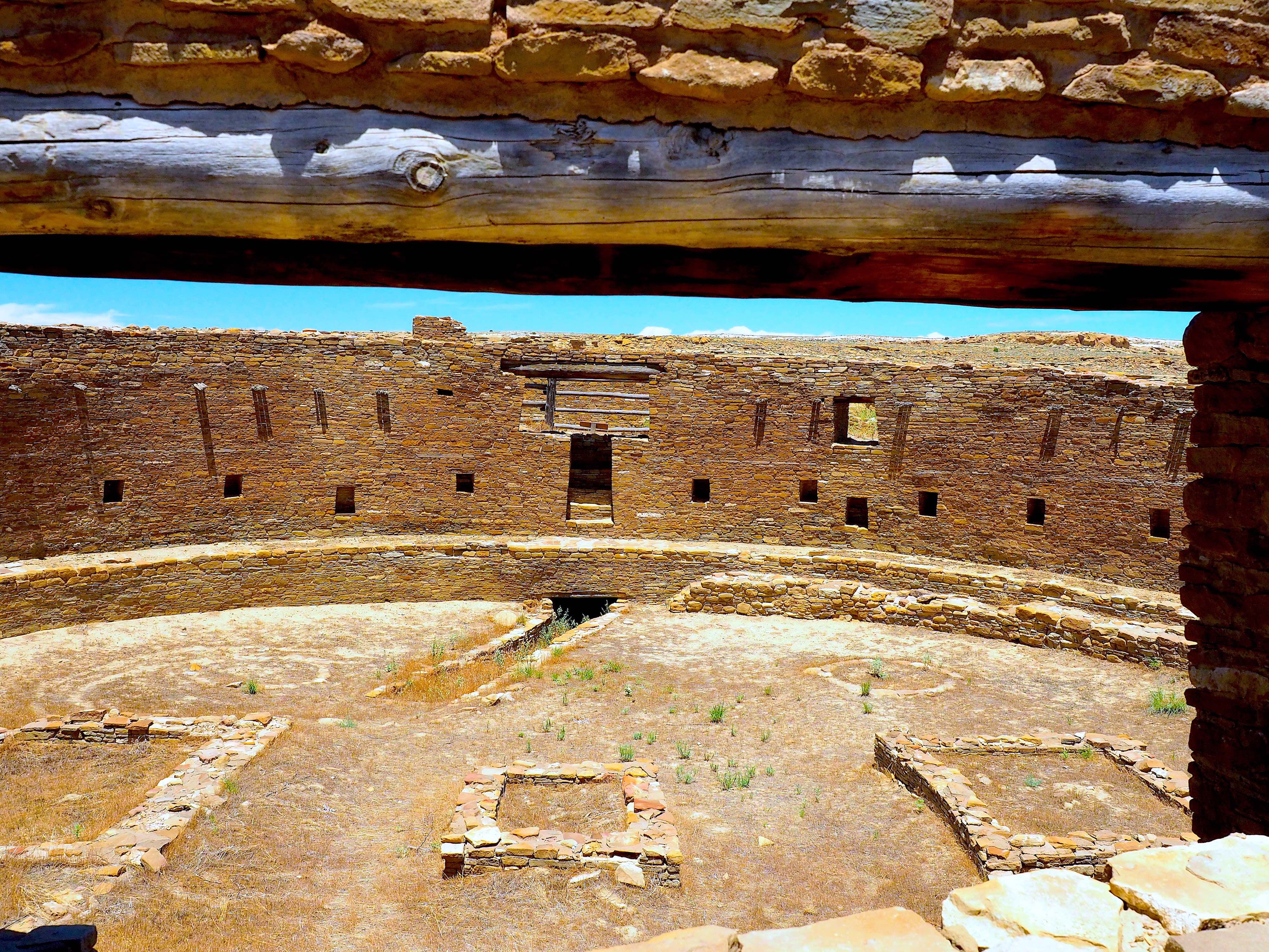
Between AD 900 and 1150, the Chacoans quarried sandstone blocks and hauled timber from mountain ranges more than fifty miles away to construct fifteen major complexes in this arid canyon. The largest, Pueblo Bonito, covered nearly two acres and contained at least 650 rooms stacked four stories high. Its scale, upon completion, rivaled that of the Roman Colosseum. The builders used core-and-veneer masonry, with walls up to three feet thick, and divided the entire complex along a wall precisely aligned north-south. A great kiva stood on each side, creating perfect symmetry. Nearby Chetro Ketl required an estimated 29,135 man-hours of labor, the wood of 5,000 trees, and 50 million stone blocks. These were not improvised shelters. They were pre-planned architectural statements - geometry, engineering, and spiritual intent fused into sandstone and timber on a scale that remained unmatched on the continent for seven hundred years.
The Middle of Time
The Chacoans did not simply build large structures - they aimed them at the sky. At least twelve of the fourteen principal complexes appear to have been oriented along axes mirroring the passage of the Sun and Moon at visually pivotal moments. Pueblo Bonito and Chetro Ketl sit along a precisely east-west line that captures the equinox sunrise. Pueblo Alto and Tsin Kletzin align north-south. Two outlying complexes, Pueblo Pintado and Kin Bineola, lie on paths collinear with the setting of the mid-winter minimum moon, which recurs every 18.6 years. The Sun Dagger petroglyph at Fajada Butte recorded this same cycle: each of the 9.25 turns of its larger spiral marks one year, with a shadow's edge stepping outward ring by ring from minimum to maximum moon. Artist Anna Sofaer, who discovered the Sun Dagger, described the Chacoans as marking "the middle of time." Public access to the butte was closed in 1989 after modern foot traffic shifted one of the three screening slabs from its ancient position.
Roads to Nowhere
Radiating from the central canyon, six road systems connected at least thirty outlying communities spread across the San Juan Basin. These were not footpaths. The Chacoan roads were engineered thoroughfares with scraped caliche beds up to thirty feet wide, bounded by earthen berms or low rock walls. Where cliffs blocked the route, the builders carved steep stone stairways and rock ramps directly into the sandstone. The roads ran in remarkably straight lines, sometimes for dozens of miles. Their purpose remains debated - Navajo tradition holds the Ancestral Puebloans built them to transport timber, and archaeologist Neil Judd offered a similar theory. Others suggest they served ceremonial functions, connecting sacred sites and pilgrimage routes. The Great North Road, extending north from Pueblo Alto in a ramrod-straight line, is believed by modern Pueblo Indians to reference their origin stories of arrival from the north. By AD 1115, at least seventy outlying pueblos of Chacoan design had been built across the basin, linked to this enigmatic web.
A Civilization Unravels
Around 1130, an extreme drought struck the region and persisted for fifty years. The cohesive Chacoan system began unraveling. Deforestation had already stripped the canyon bare - timber for construction had to be hauled from the Chuska Mountains more than fifty miles to the west. Poor water management led to arroyo cutting that eroded the canyon floor. Outlying communities depopulated first. By the end of the twelfth century, the buildings in the central canyon had been neatly sealed and abandoned - not destroyed, not burned, but deliberately closed, as if their inhabitants expected to return. Archaeogenomic analysis of skeletons from high-status graves at Pueblo Bonito revealed that members of an elite matrilineal dynasty were buried there for approximately 330 years, suggesting deep continuity of leadership. DNA evidence establishes that the people of modern Picuris Pueblo once lived in Chaco Canyon. The Hopi and Pueblo peoples maintain oral accounts of their migration from Chaco and their ongoing spiritual relationship with the land.
Dark Sky Sanctuary
Chaco Canyon's extreme remoteness - the quality that makes it difficult to visit - also makes it one of the finest stargazing sites in North America. In 2013, the park was designated a Gold-tier Dark Sky Park by the International Dark-Sky Association. The Chaco Observatory, inaugurated in 1998, draws some 14,000 visitors annually who come to see the same skies the Ancestral Puebloans tracked with such care. The park preserves more than 2,400 archaeological sites within its boundaries, though only a small percentage have been excavated. Since 1981, park policy has favored non-invasive methods - remote sensing, dendrochronology, and study of Indian oral traditions - over the aggressive digs that once dismantled compound walls and extracted thousands of artifacts. The Chaco American Indian Consultation Committee, established in 1991, gives Navajo, Hopi, Pueblo, and other tribal representatives a voice in managing these ancestral homelands.
From the Air
Located at 36.06°N, 107.96°W in remote northwestern New Mexico, within the San Juan Basin atop the Colorado Plateau. The canyon runs northwest-to-southeast and is rimmed by flat mesas. Pueblo Bonito and other major ruins are visible as cleared geometric patterns on the canyon floor. The Chaco Wash bisects the canyon. Fajada Butte is a distinctive landmark near the southeastern entrance. Nearest airports: Farmington Four Corners Regional (KFMN) approximately 75 miles north, Albuquerque International Sunport (KABQ) approximately 160 miles southeast. The park has no paved access roads - approach from the north via US-550 and County Road 7900. Elevation approximately 6,200 feet. The Chuska Mountains are visible to the west, the San Juan Mountains to the north.