Chagres and Fort San Lorenzo
Columbus found the river in 1502, on his fourth and final voyage. He was searching for a passage to Asia. What he found instead was the mouth of the Chagres, a waterway that would become the most strategically valuable river in the Western Hemisphere -- not because it led to the Pacific, but because it led most of the way. For the next four centuries, whoever controlled the Chagres controlled the fastest route across the isthmus of Panama. Spain built a fort to hold it. Pirates burned the fort to take it. Americans rode its current on the way to California gold. And then the Panama Railroad made the river irrelevant, and the jungle swallowed what everyone had fought over.
Stone Walls Against Wooden Ships
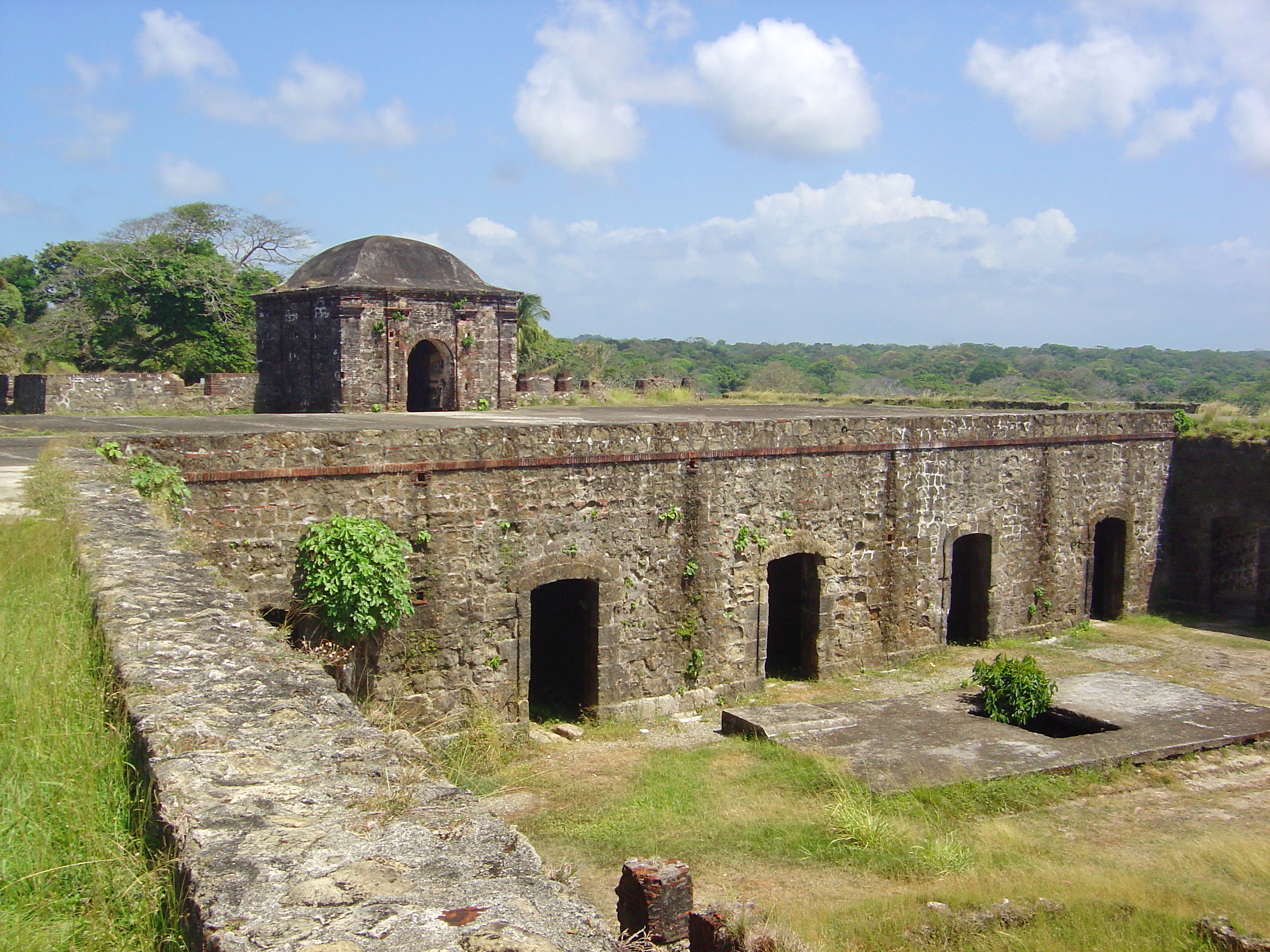
Pirates began raiding Panama's coast around 1560, drawn by the silver and gold crossing the isthmus on the Camino Real from Panama City to the Caribbean port of Portobelo. To guard the Atlantic end of the trail, Spain ordered the construction of Fort San Lorenzo at the mouth of the Chagres River, with work beginning in 1598 under King Philip II. The fort sat on a promontory overlooking the river's entrance, a natural chokepoint where cannon could command approaching ships. It did not always hold. In 1671, forces under the English privateer Henry Morgan stormed the fort on their way to sacking Panama City. Over the following decades, the fortification was rebuilt and strengthened, only to be attacked again by British Admiral Edward Vernon during the War of Jenkins' Ear in 1740. The cycle of destruction and reconstruction gave Fort San Lorenzo the layered architecture of a place that has been fought over more than it has been lived in.
Boomtown on the Chagres
For a century after the Spanish abandoned both overland trails across the isthmus, preferring the long voyage around Cape Horn, the Chagres River slept. Fort San Lorenzo served as a prison. The village of Chagres shrank to a scattering of huts. Then, in 1849, the California Gold Rush jolted the isthmus back to life. Steamships from the American East Coast deposited thousands of travelers at the river's mouth, where a wild-west boomtown called Yanqui Chagres sprang up on the opposite bank from the old village. Steamboat service on the Chagres cut the crossing from days to roughly twelve hours. But the boom died almost as quickly as it began. When the Panama Railway was completed in 1855, reducing transcontinental travel to about three hours, its Atlantic terminus at Colon became the isthmus's primary port. Chagres, bypassed, faded back into obscurity.
Heritage in the Jungle
Fort San Lorenzo has been government-protected since 1908, and today the ruins and the village site lie within the 30,000-acre San Lorenzo Protected Area, former Canal Zone territory. In 1980, UNESCO declared the fort a World Heritage Site alongside the fortified town of Portobelo, 30 miles to the northeast, under the title Fortifications on the Caribbean Side of Panama. UNESCO described them as magnificent examples of 17th- and 18th-century military architecture, part of the defense system the Spanish Crown built to protect transatlantic trade. The jungle has been a persistent third party in the fort's history, reclaiming stonework between each human abandonment. Vines push through gun embrasures. Trees root in the parade ground. The promontory still commands a view of the river mouth, but the ships it was built to repel stopped coming long ago.
The River That Shaped the Canal
The Chagres River outlasted every human settlement built along it. Its waters were dammed in 1913 to create Gatun Lake, the vast artificial body of water that forms the central passage of the Panama Canal. The same river that carried gold rush travelers upstream on barges now fills the locks that lift container ships 85 feet above sea level. Fort San Lorenzo watches over the river mouth as it always has, though the traffic it once guarded now enters the canal at Colon, several miles to the east. From the fort's crumbling battlements, the Caribbean stretches north and the Chagres curves south into jungle that has barely changed since Columbus sailed past in 1502. The village of Chagres is gone. The fort remains, less a ruin than a monument to the proposition that geography is destiny -- and that destiny can be rerouted by a railroad.
From the Air
Fort San Lorenzo sits at 9.32N, 80.00W on a promontory overlooking the mouth of the Chagres River on the Caribbean coast of Panama, approximately 8 miles west of Colon. From 2,000-4,000 feet AGL, the fort's position on the headland is visible where the river meets the sea. The San Lorenzo Protected Area, a 30,000-acre forested zone, surrounds the site. Enrique Adolfo Jimenez Airport (MPEJ) at Colon is the nearest airfield. The Gatun Locks of the Panama Canal are visible to the east. Tropical maritime weather prevails, with frequent rain and reduced visibility on the Caribbean slope.