Chaine des Puys
Before 1750, no one in France believed the rounded hills of central Auvergne were volcanoes. Locals assumed the mounds were waste piles from Roman-era mining operations, or perhaps the remains of ancient forge furnaces. The idea that fire had shaped this pastoral landscape seemed absurd. Then geologists looked closer, and the Chaine des Puys revealed itself as one of the youngest and most perfectly preserved volcanic chains in Europe -- a 40-kilometer parade of cinder cones, lava domes, and explosion craters stretching north to south through the heart of the Massif Central, dormant but not dead.
A Textbook Written in Stone
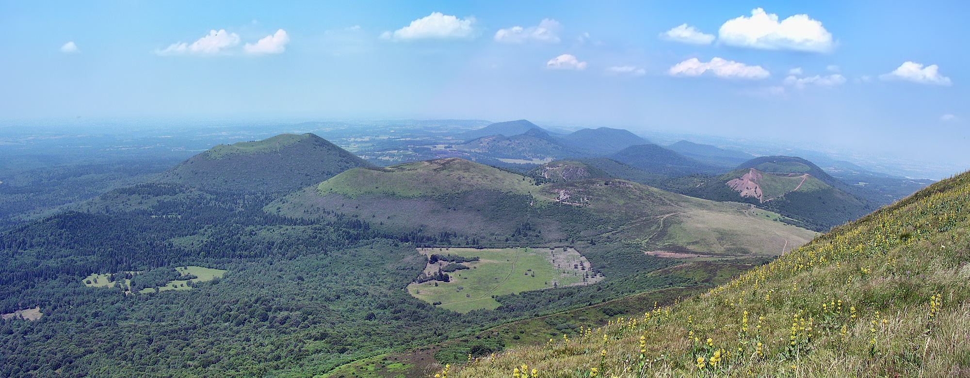
The numbers alone are striking: 48 cinder cones, eight lava domes, and 15 maars and explosion craters, all arranged along a single north-south axis. The chain sits on the Limagne fault, part of the European Cenozoic Rift System that formed roughly 35 million years ago during the creation of the Alps. But the volcanic activity here is far more recent than the fault itself. The most recent eruptions occurred only about 6,700 years ago, making these among the youngest volcanoes in mainland France. At the chain's center rises Puy de Dome, a lava dome that serves as both the highest point and the visual anchor of the entire formation. UNESCO recognized the chain as a World Heritage Site in 2018, citing it as an outstanding example of continental rifting and plate tectonics visible at the Earth's surface.
The Geologist Who Saw First
The scientific discovery of the Chaine des Puys belongs largely to English geologist George Julius Poulett Scrope. Beginning his fieldwork in the 1820s, Scrope recognized what local observers had missed for centuries: these hills were volcanic, and their extraordinary state of preservation made them ideal for understanding how volcanoes form and erode. In 1827 he published his Memoir on the Geology of Central France, the first widely circulated description of the chain. A revised and more accessible edition followed in 1858 as The Geology and Extinct Volcanos of Central France. These works laid the foundation for many of the basic principles of volcanology. Scrope's achievement was not just identification but interpretation -- he showed that the variety of volcanic forms visible in the Chaine des Puys, from simple cinder cones to complex lava domes to maar craters, could be explained by a single coherent set of geological processes.
Cones, Domes, and Craters
What makes the Chaine des Puys exceptional is not just its volcanic nature but the diversity and clarity of its landforms. The cinder cones are textbook examples -- symmetrical hills of loose volcanic debris built by eruptions of gas-rich magma. The lava domes, including Puy de Dome itself, formed when thicker, more viscous magma pushed up from below without exploding, creating steep-sided mounds. The maars are perhaps the most dramatic: circular craters formed by violent steam explosions when rising magma encountered groundwater. Some of these maars now hold lakes, their nearly perfect circles visible from the air like dark mirrors set into the green hills. Together, these three volcanic forms represent the full spectrum of volcanic behavior, all visible within a single chain barely 25 miles long.
Dormant, Not Extinct
The classification matters. The Chaine des Puys is categorized as potentially active, not extinct. The most recent eruptions happened in the Neolithic period, well within the geological blink of an eye. The Limagne fault remains seismically active, and the volcanic plumbing beneath the chain has not disappeared. This is not a museum of dead geology but a landscape that could, in theory, erupt again. For now, though, the puys are green and pastoral. Sheep graze on slopes that were once rivers of molten rock. Hikers climb Puy de Dome on trails that cross ancient lava flows. From the air, the chain reads as a line of gentle humps, deceptively calm, their volcanic origins apparent only in their suspicious regularity and the occasional maar lake glinting below. The contrast between the violence that created them and the tranquility that currently defines them is the chain's quiet drama.
From the Air
Located at 45.50N, 2.80E in the Massif Central of central France. The chain stretches roughly 40 km north-south and is best appreciated from 5,000-10,000 ft AGL, where the alignment of cones and the circular maar lakes become clearly visible. Puy de Dome (1,465 m / 4,806 ft) is the dominant visual feature near the center of the chain. Nearest major airport is Clermont-Ferrand Auvergne (LFLC). Clear weather provides the best visibility of the volcanic forms against the surrounding agricultural landscape.