Chatterbox Falls
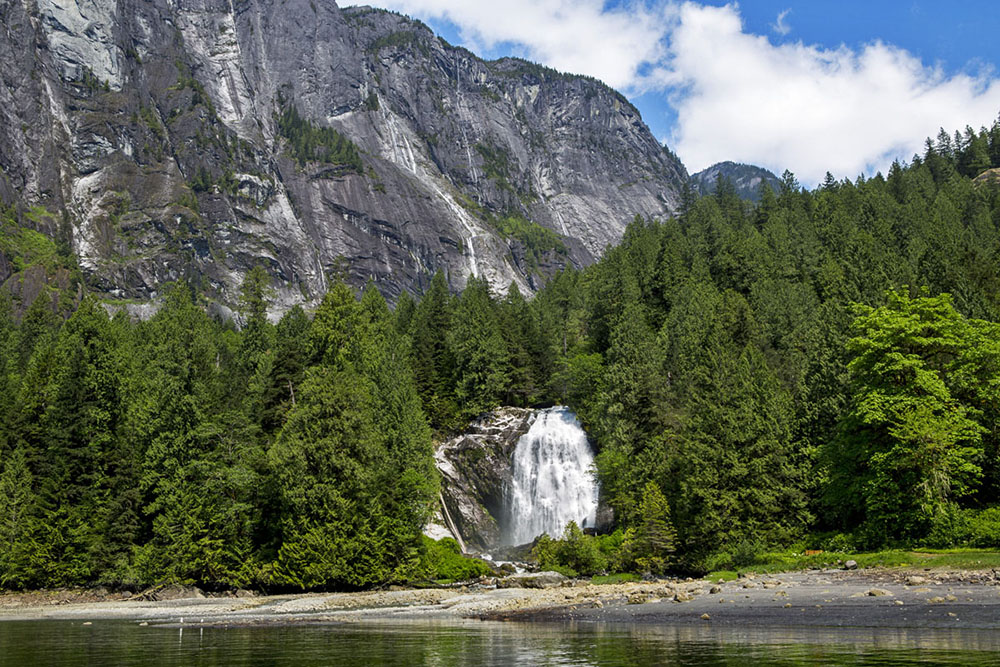
You hear Chatterbox Falls before you see it. The sound builds as your boat rounds the final bend of Princess Louisa Inlet -- a deep, percussive roar that bounces off granite walls rising thousands of feet on either side. Then the falls appear: a wide curtain of white water pouring down a rock face at the very head of the fjord, where Loquilts Creek makes its final descent into saltwater. It is the exclamation point at the end of one of the most dramatic waterways on the Pacific coast, and boaters have been making pilgrimages to reach it for over a century.
The Reward at the End of the Fjord
Reaching Chatterbox Falls requires commitment. Princess Louisa Inlet lies at the northeastern end of Jervis Inlet, itself a long fjord cutting deep into the BC mainland from the Sunshine Coast. To enter Princess Louisa, boats must navigate Malibu Rapids, a narrow tidal choke point where currents can reach 9 knots during peak flow. Timing the transit for slack water is essential -- miss it, and the rapids become impassable. Once through, the inlet stretches 6 kilometers to the falls, its walls climbing steeply on both sides, waterfalls streaming down from snowfields above. The journey imposes a rhythm of patience and anticipation that makes the arrival feel earned.
North America's Tallest Neighbor
Chatterbox Falls is not the only waterfall at the head of Princess Louisa Inlet, and it is not even the tallest. Just upstream, James Bruce Falls drops 2,755 feet down the mountainside, making it the tallest waterfall in North America. But James Bruce Falls is a high-altitude cascade, visible as a silver thread on the rock face far above. Chatterbox is the one you stand next to. A trail from the park dock leads through moss-draped forest to the base of the falls, where mist soaks everything within a hundred meters. Loquilts Creek, the stream that feeds the falls, drains the alpine snowfields and glaciers above, and its volume swells dramatically in late spring and early summer as the snowpack melts.
A Park Born from Devotion
Princess Louisa Marine Provincial Park, established in 1965, protects the head of the inlet and the land surrounding Chatterbox Falls. The park exists largely because of decades of advocacy by people who fell in love with the place and fought to keep it from private development. The Princess Louisa International Society continues to cooperate with BC Parks in managing the area, maintaining moorage facilities and trails for the thousands of boaters who visit each summer. The park operates on a simple principle: this place is too extraordinary to belong to anyone in particular. Kayakers, sailboaters, and powerboaters share the anchorage, tying to stern buoys and park docks, and the sound of the falls provides a continuous backdrop.
Water, Rock, and Time
The geology that created Chatterbox Falls is the same geology that carved Princess Louisa Inlet itself. Glaciers gouged the fjord during the last ice age, leaving walls so steep that the water drops to enormous depth just meters from shore. The falls mark the point where the creek, flowing down from the Coast Mountains, meets the fjord head. The rock face is a canvas of green moss and grey granite, streaked dark where water flows and pale where it does not. In winter, the falls partially freeze, and the inlet falls silent except for the creak of ice and the occasional cry of an eagle. In summer, the water runs full and fast, and the mist rising from the plunge pool catches the light filtering down between the canyon walls. It is the kind of place that makes people rearrange their lives to come back.
From the Air
Located at 50.21°N, 123.77°W at the head of Princess Louisa Inlet, a narrow fjord branching off the northeast end of Jervis Inlet. The falls are at the terminus of the fjord, surrounded by steep walls rising over 2,000 ft. Best viewed from above at 3,000-5,000 ft; the white water is visible against the dark rock. Nearest airport is Sechelt-Gibsons Airport (CAP3) approximately 40 nm to the south. The fjord walls make low-altitude overflights inadvisable. Look for the narrow gap of Malibu Rapids at the inlet's entrance as an orientation landmark.