Chaudière Falls
The Anishinaabe saw a peace pipe. Where the Ottawa River narrows between rocky escarpments in the centre of what is now Ottawa-Gatineau, the water once plunged into a churning basin shaped like a great cauldron. The whirlpool at its base was the bowl of the pipe, and the mists rising from the falls were smoke carrying prayers to the Creator. For thousands of years, Indigenous peoples gathered at Akikodjiwan - the place of the kettle - to trade, to make offerings of tobacco, and to negotiate safe passage along the continent's great interior waterways. Then Samuel de Champlain arrived in 1613 and wrote in his journal about the thundering cascade, translating the Indigenous word for boiler into French: chaudière. The name stuck. The sacred site would spend the next four centuries being dammed, industrialized, and hidden from public view - only to re-emerge in the 21st century as one of the most contested pieces of real estate in the national capital.
The Kettle and the Ceremony
Before European contact, the Chaudière Falls and surrounding islands formed one of the most important meeting places in northeastern North America. The Algonquin Anishinaabe, primary inhabitants of the Ottawa River watershed they called Kichi Sipi, carved intricate networks of portage routes around the falls. Water levels fluctuated dramatically with seasonal rains and snowmelt, flooding the islands and reshaping the landscape year after year. The falls themselves held deep spiritual significance. When Champlain witnessed Indigenous ceremony here on June 14, 1613, he recorded people placing pieces of tobacco on a wooden plate, dancing and singing around it, then casting the offering into the churning water. The Mohawks called the site Tsitkanajoh - the Floating Kettle - while the Onondaga named it Katsidagweh niyoh, or Chief Council Fire. Victoria Island, perched at the meeting point of three rivers, was known as Asinabka - Place of Glare Rock - and served as a center of convergence for trade and spiritual exchange.
Timber Barons and Royal Thrill-Seekers
Philemon Wright's arrival in 1800 transformed the falls from sacred gathering place to industrial powerhouse. The region's first bridge, Union Bridge, went up close to the falls in 1827. When the lumber industry expanded upstream, the falls became an obstacle that demanded engineering solutions. Wright's son Ruggles built the first timber slide in 1829, allowing logs and timber rafts to bypass the cascades along the north shore. A second slide, built by George Buchannan in 1836 between Victoria and Chaudière Islands, became a major tourist attraction. The thrill of 'shooting the slides' on a timber crib drew visitors from around the world - including future King Edward VII in 1860 and future King George V in 1901. Meanwhile, some of Canada's largest sawmills clustered near the falls. Lumber barons Henry Franklin Bronson and John Rudolphus Booth built empires on the river's power. The E. B. Eddy Company operated matchmaking and pulp mills. By the early 20th century, every island and shoreline had been developed, and in 1910, a ring dam was built to divert the river's flow to hydroelectric generating stations.
Hidden in Plain Sight
For generations, the Chaudière Falls essentially vanished. The ring dam and power stations diverted so much water that during summer low flows, the falls all but disappeared. Industrial complexes blocked public access. The E. B. Eddy Company's operations dominated the site until Montreal-based Domtar acquired them in 1998; operations ceased in 2007. Hydro Ottawa purchased the site in 2012, including the ring dam and water rights, and doubled the generating capacity of its stations from 29 to 58 megawatts by 2017. That same year, architect Douglas Cardinal - a world-renowned Indigenous designer - helped create Chaudière Falls Park, opening public access to the falls for the first time in living memory. Suddenly, residents of Canada's capital could see the waterfall that had been there all along, hidden behind fences and factory walls in the geographic heart of their city.
The Battle for the Islands
The falls' re-emergence sparked a fierce debate about what this place should become. The Zibi development project, a mixed-use redevelopment on the northern riverbank and on Chaudière and Albert Islands, promises approximately 3,500 residents and repurposed heritage buildings. The project takes its name from the Algonquin Anishinabe word for river. But the development has divided Indigenous communities. The Algonquins of Pikwakanagan First Nation partnered with developers, with Chief Kirby Whiteduck declaring that 'the Algonquin people don't need to be saved from the Zibi project.' Other communities and the 'Free The Falls' movement advocate returning the islands to their natural state and Indigenous stewardship, invoking the vision of the late Algonquin elder William Commanda for Asinabka as a site of healing and peacekeeping. Meanwhile, the National Capital Commission is leading plans for an Indigenous welcome centre on Victoria Island. The outcome will determine whether one of North America's oldest gathering places becomes a condo development, a cultural centre, or something in between.
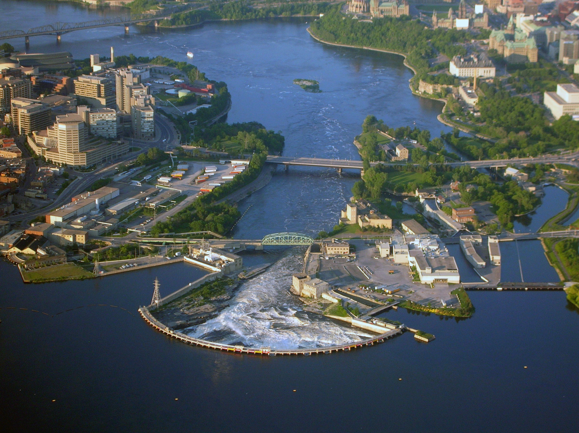
From the Air
Located at 45.42°N, 75.71°W, the Chaudière Falls sit at the narrowing of the Ottawa River between Ottawa and Gatineau, immediately west of the Chaudière Bridge. From altitude, the cluster of islands (Chaudière, Albert, Victoria) and the ring dam are clearly visible, along with the adjacent hydroelectric facilities. Parliament Hill is approximately 1 km to the east. The Canadian War Museum at LeBreton Flats is just southeast. Nearby airports include Ottawa/Macdonald-Cartier International (CYOW, 10 km south) and Gatineau-Ottawa Executive (CYND, 8 km north). The falls are best viewed from lower altitudes where the white water and industrial heritage buildings are distinguishable from the surrounding urban fabric.