Chehalis River
In December 2007, Interstate 5 -- the West Coast's main artery from Mexico to Canada -- disappeared under ten feet of water near Centralia, Washington. The recommended detour added four hours and 280 miles. Two years later, it happened again, and this time every mountain pass was closed too. The Chehalis River had effectively cut the Pacific Northwest in half. For a river most Americans have never heard of, the Chehalis commands an outsized drainage basin: approximately 2,700 square miles across four counties, the largest watershed entirely contained within Washington state. It was carving this valley long before the highway existed -- long before humans existed -- when glacial meltwater gouged the oversized valley that the Chehalis now wanders through like a child wearing a parent's coat.
Shaped by a Glacier's Retreat
During the last Ice Age, the Puget Lobe of the Cordilleran Ice Sheet pushed south to roughly where Olympia sits today. When the ice began to melt, the runoff had to go somewhere, and the Chehalis Valley became the drain. Glacial Lake Russell formed behind the retreating ice and emptied through the river corridor, sending torrents of meltwater westward that carved a valley far wider and deeper than the modest river flowing through it now. The Chehalis's mouth was originally near present-day Westport, but rising sea levels at the end of the Ice Age flooded the broad lower valley, creating the drowned river mouth -- a ria -- that we now call Grays Harbor. Slow deposits of glacial sediment gradually raised the depressed valley floor. The landscape you see from the air today is the aftermath of that ancient plumbing: a wide, flat-bottomed valley with a winding river that seems too small for the space it occupies.
The River's Own Rights
The Chehalis is one of only two river basins in Washington -- the other being the Dungeness -- protected under in-stream flow regulation, a 1976 law that grants the river the right to maintain its own water levels. This is not a metaphor. The river has legal standing to keep enough water flowing to sustain its ecosystem. Senior water rights holders, grandfathered from before 1976, retain unfettered access; these are mostly tribal communities and farmers whose claims predate modern water law. As of recent counts, 93 junior rights holders -- mostly homeowners -- draw from the Chehalis basin under more restricted terms. The Quinault Indian Nation and the Confederated Tribes of the Chehalis Reservation remain stakeholders of the river, with fishing and hatchery rights on the Chehalis system. The Chehalis people never signed the Treaty of Olympia or any other treaty, and the Confederated Tribes of the Chehalis Reservation was established by executive order in 1864 rather than by treaty agreement.
When the Water Rises
The Chehalis floods the way other rivers flow -- regularly and emphatically. The December 2007 event, triggered by the Great Coastal Gale, put a 20-mile stretch of Interstate 5 between exits 68 and 88 under water deep enough to submerge a car. Governor Christine Gregoire declared a state of emergency. Amtrak service between Portland and Vancouver, B.C., was disrupted. When crews breached a dike on December 5, the water receded faster than expected, but the message was clear. In January 2009, the river did it again -- same stretch, same highway, but this time the Cascade passes were also closed, leaving no detour at all. The Puget Sound region was temporarily an island, reachable from the south only by air or water. These floods are not anomalies; they are features of a valley designed by glacial hydrology to carry vastly more water than it usually does.
A Braided Path to the Sea
The Chehalis begins where the West Fork and East Fork converge in southwestern Lewis County, then flows north and east through the Willapa Hills, collecting tributaries like a net gathering threads. The Newaukum River enters at the city of Chehalis, and the Skookumchuck joins at Centralia -- names drawn from the Chinook Jargon that once served as the trade language of the Pacific Northwest. After Centralia, the river turns north and west, passing through the Chehalis Gap to collect the Satsop and Wynoochee Rivers draining the southern Olympics. Near Montesano, tidal influence begins and the river widens steadily. At Aberdeen, the Wishkah joins from the east and the Hoquiam River from the west, and the Chehalis becomes Grays Harbor -- a broad estuary where freshwater meets the Pacific.
Salmon, Strategy, and What Comes Next
Chum, coho, fall Chinook salmon, and steelhead trout all use the Chehalis basin, making the river a critical piece of Pacific Northwest fisheries. In 2014, a coalition of counties, tribes, environmental groups, and the Washington Department of Fish and Wildlife formed the Chehalis Basin Strategy, a partnership aimed at both reducing flood damage and restoring aquatic habitat. The initial plan proposed levee improvements near the Chehalis-Centralia Airport and a flood retention dam at Pe Ell to buffer 100-year flood events. The tension at the heart of the strategy is the same tension that defines the Chehalis itself: a river that humans need for water, food, transportation, and recreation, but that periodically reclaims the valley it carved. The cities of Aberdeen, Centralia, Chehalis, and Hoquiam all depend on the river. The salmon depend on it too. Finding a balance that serves both has become one of southwestern Washington's defining challenges.
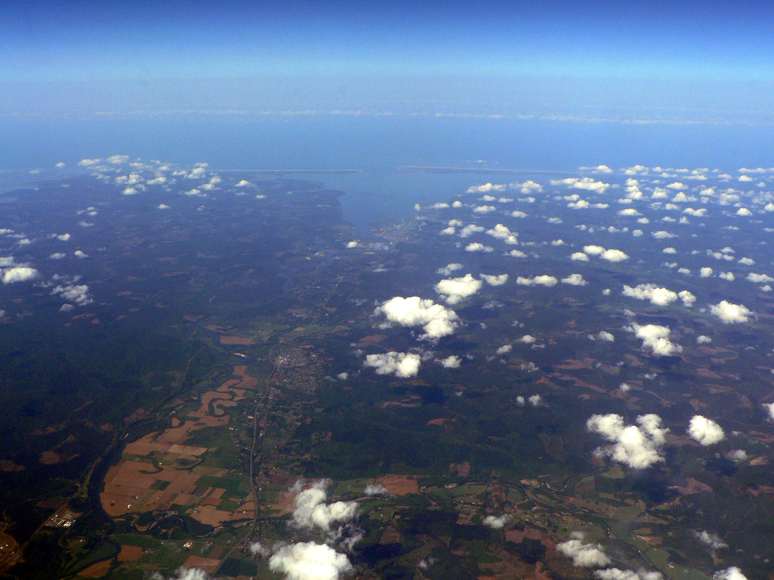
From the Air
The Chehalis River mouth at Grays Harbor is located near 46.96°N, 123.83°W. The river is easily visible from altitude as it winds through the wide, flat valley between the Willapa Hills to the south and the Olympic foothills to the north. Interstate 5 crosses the valley near Centralia and Chehalis -- the notorious flood zone is clearly visible as a low, flat stretch surrounded by higher ground. Key airports include Bowerman Field (KHQM) at Hoquiam near the river mouth, Chehalis-Centralia Airport (KCLS) in the flood-prone midsection, and Olympia Regional Airport (KOLM) to the east. The river's winding course, the broad tidal flats of Grays Harbor, and the convergence of multiple tributaries make it one of the most distinctive hydrological features visible from the air in southwestern Washington.