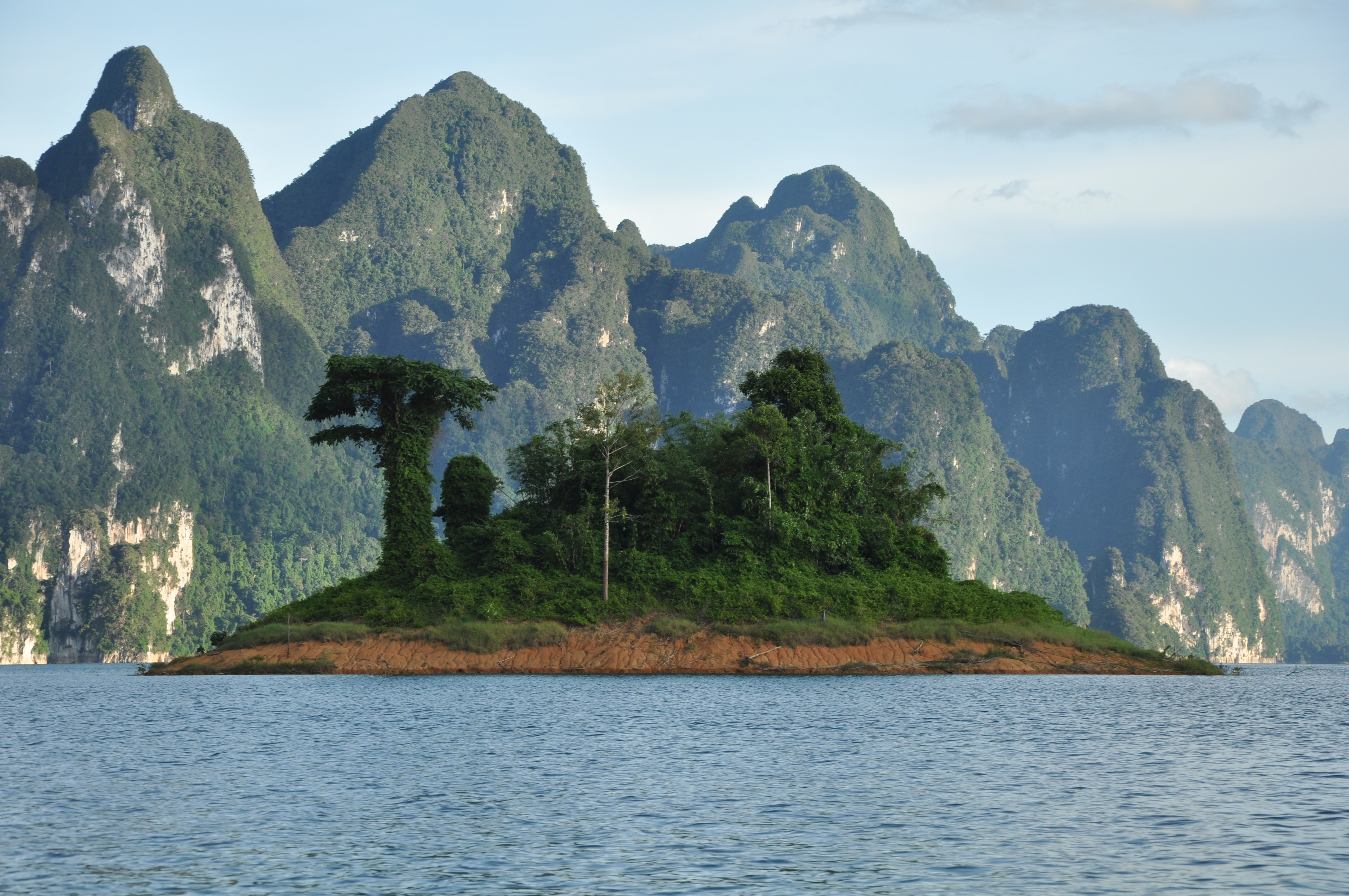
Cheow Lan Lake
In 1987, a king named a dam. Rajjaprabha, he called it: "light of the kingdom." Before that day, the project had a simpler name, the Cheow Lan Project, after the village that would disappear beneath 185 square kilometers of rising water. Today, Cheow Lan Lake fills a basin in Khao Sok National Park in Surat Thani Province, Thailand, its emerald surface broken by limestone karst towers that jut skyward like the ruins of a drowned cathedral. The dead trunks of the preexisting forest still pierce the waterline in places, pale and skeletal, monuments to the valley that was.
The Village Beneath the Water
The Electricity Generating Authority of Thailand began construction in 1982 by diverting the Klong Saeng River. The dam was designed as a multi-purpose project: power generation, flood control, irrigation, and fishery. But filling a 185-square-kilometer basin required emptying it first. Three hundred eighty-five families from Ban Chiew Lan village were resettled. Each family received 19 rai of rubber plantation and one rai for a dwelling, along with 1,000 baht per month in compensation. The Thai government built schools, a police station, a medical center, and a community hall for the displaced residents. Rubber farming, poultry, fruit orchards, vegetable plots, and reservoir fisheries were introduced with training programs and credit to sustain the families' incomes. It took about one year for the water to completely fill the basin. Somewhere beneath that green surface, the foundations of Ban Chiew Lan remain.
Rescue by Helicopter
As the water rose through 1986 and 1987, it created islands where ridgelines broke the surface, stranding animals on shrinking patches of forest. What followed was one of Thailand's most ambitious wildlife rescue operations. Over 18 months, teams working by boat and helicopter captured 1,364 animals representing 116 species, ferrying them to safe ground before their islands disappeared entirely. Forty-four of the rescued animals died soon after relocation. Many fish species in the original river system perished as the flowing water turned stagnant. The rescue operation was a remarkable logistical effort and an honest reckoning with what dam-building costs beyond the human displacement that dominates most accounts. The animals had no villages, no compensation packages, no training programs. They had boats and helicopters, if they were lucky, and drowning if they were not.
Karst and Canopy
The lake sits within a protected landscape that extends across roughly 4,000 square kilometers when neighboring reserves are included. Khlong Saeng, Khlong Nakha, and Kaeng Krung wildlife sanctuaries border the reservoir, while Sri Phang Nga National Park stretches the preservation corridor westward. Limestone karst formations rise directly from the water, their sheer walls draped in vegetation, their bases hollowed by caves. The surrounding rainforest is among the oldest on Earth, predating even the Amazon, and it harbors a density of life that rewards patience. Elephants and tapirs move through the understory. Hornbills, banded pittas, and great argus pheasants call from the canopy. King cobras, reticulated pythons, and flying lizards occupy the gaps between. The lake's calm surface reflects all of it, karst, forest, sky, creating a doubled landscape that makes the place feel less like a reservoir and more like a world that always existed.
Light of the Kingdom
The name Rajjaprabha was bestowed by King Bhumibol Adulyadej at the dam's inauguration ceremony on September 30, 1987. The timing was deliberate, linking a major infrastructure achievement to a royal milestone. The dam generates hydroelectric power for southern Thailand, controls flooding along the Klong Saeng watershed, and supplies irrigation water to surrounding farmland. These are the utilitarian facts. But the lake has become something its engineers likely never intended: one of Thailand's most striking natural attractions, a place where kayakers paddle at dawn through mist rising off water so still it looks like glass, where floating raft houses serve as base camps for treks into primary rainforest, and where the ghosts of drowned trees remind visitors that beauty and loss are not opposites. They are, in this flooded valley, the same thing.
From the Air
Located at 9.00N, 98.77E within Khao Sok National Park, Surat Thani Province, Thailand. The 185-square-kilometer lake is a prominent visual feature, its emerald water contrasting with surrounding dark green rainforest and pale limestone karst towers. Nearest major airport is Surat Thani Airport (VTSB), approximately 80 km to the east. Phuket International (VTSP) lies about 130 km to the southwest. At 3,000-5,000 feet, the full extent of the lake is visible, including the distinctive karst formations rising from the water. The Rajjaprabha Dam is identifiable at the lake's southern end.