Cherangani Hills Forest
Every cup of water in western Kenya begins here. The Cherangani Hills rise along the western edge of the East African Rift, their slopes wrapped in forest that catches the moisture rolling in from Lake Victoria and channels it into the Kerio, Nzoia, and Turkwel rivers. These are not dramatic volcanic peaks or glacier-capped summits. They are working mountains, quiet and green, doing the unglamorous job of keeping an entire region alive. The thirteen forest reserves that make up the Cherangani Hills Forest cover roughly 1,200 square kilometers, with 956 square kilometers formally gazetted as protected land. What happens beneath that canopy determines the future of millions of people downstream.
Kenya's Green Water Towers
The Cherangani Hills function as one of Kenya's five major water towers, catchment areas whose forests intercept rainfall and release it slowly into rivers that sustain agriculture, cities, and ecosystems far beyond their borders. The Kerio River flows north into the barren landscapes approaching Lake Turkana. The Nzoia runs west toward Lake Victoria, watering some of Kenya's most productive farmland along the way. The Turkwel carves through arid country to the northwest, feeding a hydroelectric dam before it too reaches the dry lowlands. Without the sponge-like forest canopy absorbing and metering out rainfall, these rivers would alternate between flash floods and empty beds. The reserves carry names that speak to the Marakwet and other communities who have lived among them for generations: Kapolet, Kiptaberr, Lelan, Embobut, Chemurokoi. Each block occupies a different ridge or valley, but together they form a single hydrological system.
A Botanical Inventory
Scientists have documented 1,296 plant species across the Cherangani Hills Forest, belonging to 130 families and 608 genera. To put that in perspective, this single highland area contains 18.5 percent of all plant species known in Kenya, nearly 44 percent of the country's genera, and over 54 percent of its plant families. Seventeen of those species are endemic, found here and nowhere else. Among the threatened plants are several species of Impatiens, the delicate touch-me-not flowers that thrive in the moist understory, and Lobelia cheranganiensis, a giant rosette plant named for these very hills. The forest canopy shifts with altitude, moving from mixed montane forest at lower elevations through bamboo zones and into moorland meadows near the summits. Each band supports its own community of specialists.
The Pressures Closing In
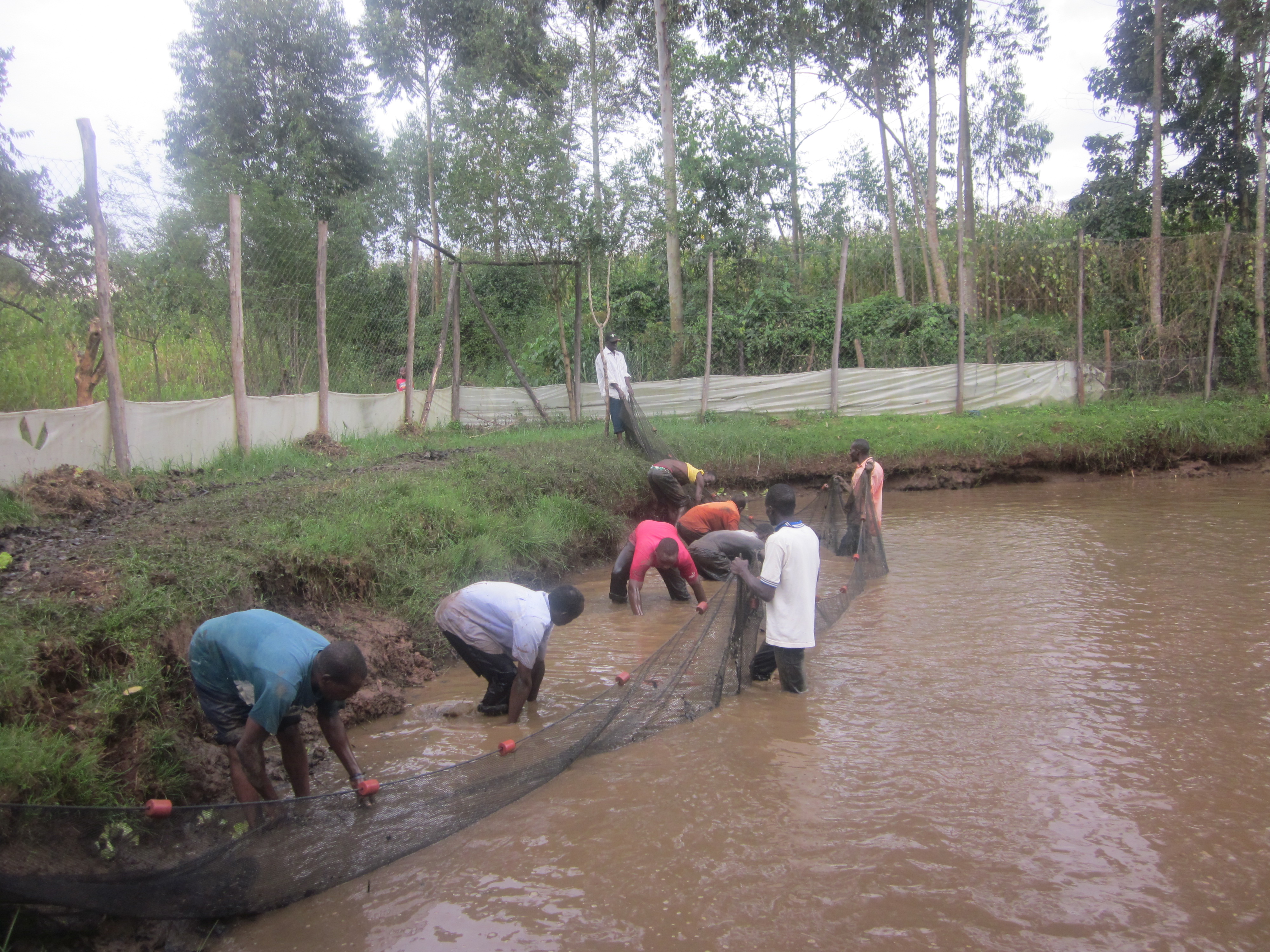
The forests are shrinking. A growing population pushes against the reserve boundaries from all sides, converting forest margins to cropland, running livestock beneath the canopy, and harvesting trees for charcoal and lumber. The pressures are not abstract or distant; they arrive as families clearing a few more acres to feed children, as charcoal burners supplying cooking fuel to towns that have no alternative. Downstream communities add their own demands, drawing more water from rivers whose flow depends on forests they may never see. Environmentalists like Rachel Nyakeri have worked with Wildlife Society officials to identify invasive vegetation and promote alternatives, including beekeeping projects designed to give forest-edge communities income that does not require felling trees, and tilapia farming ponds that reduce pressure on wild fisheries. Planted woodlots of fast-growing exotic species take some of the lumber demand off the native forest. These are practical, ground-level interventions, not sweeping policy gestures.
The Rift's Green Shoulder
From the air, the Cherangani Hills appear as a rumpled green ridge running roughly north-south, standing between the flat floor of the Rift Valley to the east and the gentler slopes descending toward Lake Victoria to the west. The contrast is stark. To the east, the land drops away into the dry, ochre-colored Kerio Valley. To the west, cultivated fields pattern the landscape in greens and browns. The forested hills sit between these two worlds, a humid island above the surrounding lowlands. On clear days, the line where montane forest gives way to farmland is visible as sharply as a drawn border. That line represents the negotiation between human need and ecological function that plays out across every water tower in East Africa. In the Cherangani Hills, the outcome of that negotiation is still being decided.
From the Air
Located at 1.30N, 35.42E on the western escarpment of the East African Rift in western Kenya. From 10,000-15,000 feet AGL, the forested ridgeline is visible running north-south, with the Kerio Valley dropping steeply to the east and agricultural lowlands spreading west toward Lake Victoria. The nearest significant airports are Eldoret International Airport (HKEL) approximately 60 km to the south and Kitale Airstrip to the southwest. Expect convective weather in afternoons during rainy seasons (March-May, September-November).