Cherrapunji
The wettest place on Earth runs dry every winter. That is the central paradox of Sohra, the town the British mispronounced as "Cherra" and the world came to know as Cherrapunji. Perched at 1,430 meters on a plateau in the Khasi Hills of Meghalaya, northeastern India, this small settlement holds two Guinness world records: 26,471 millimeters of rainfall in a single year (August 1860 to July 1861) and 9,300 millimeters in a single month (July 1861). Yet between November and February, its residents trek long distances for potable water. The same deforestation that stripped the plateau of its ability to retain moisture has turned this famously soaked landscape into something approaching xerophytic scrubland in the dry months.
Where Clouds Come to Die
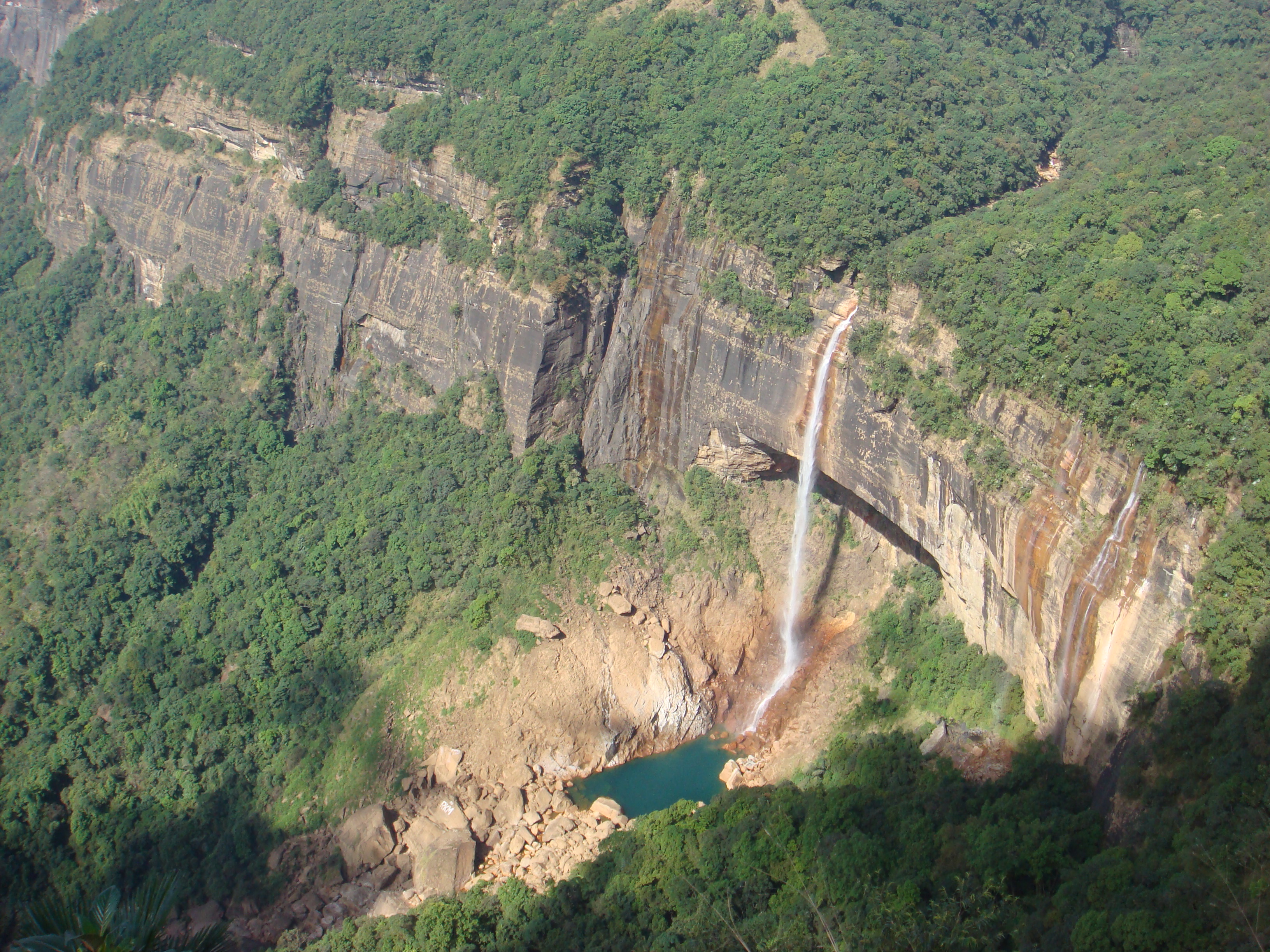
The mechanics of Sohra's extreme rainfall read like a physics demonstration. Monsoon clouds sweep north from the Bay of Bengal, traveling unimpeded across 400 kilometers of flat Bangladeshi plains. Then they slam into the Khasi Hills, which rise abruptly from near sea level to 1,370 meters within just two to five kilometers. The geography funnels low-flying moisture-laden clouds through deep valley channels, compressing them toward Sohra from multiple directions. Forced rapidly upward along steep slopes, the clouds cool and release their water in extraordinary volumes. Most of the rain falls in the morning, partly because winds trapped in the valleys overnight begin their ascent only after daytime warming. The spatial variability is extreme: cloudbursts can drench one section of Sohra while nearby areas remain dry. It is orographic precipitation at its most dramatic, a textbook case made spectacular by the sheer abruptness of the terrain.
The Khasi and Their Matrilineal World
The native inhabitants of Sohra are the Khasi people, whose history in these hills traces back to at least the sixteenth century. Their society rests on a matrilineal system: children take their mother's surname, and inheritance passes through the female line. Between the sixteenth and eighteenth centuries, Khasi society was governed by tribal Syiems, chiefs who ruled from the Khasi Hills until British authority was established in 1833 with the submission of Tirot Sing Syiem, the last major chief to resist. A monument to David Scott, the British administrator in northeastern India from 1802 to 1831, still stands in the town's cemetery, a colonial footnote in a place whose indigenous identity predates it by centuries. Today, most of Sohra's population of roughly 10,000 follow Christianity, though followers of the indigenous Niam Khasi tradition and Hinduism maintain a significant presence.
Bridges That Grow
Sohra's most astonishing adaptation to its saturated environment is also its slowest. Over centuries, the Khasi people developed techniques for training the aerial roots of rubber fig trees across rivers and ravines, coaxing them into living bridges strong enough to bear foot traffic. The process takes 10 to 15 years, but the resulting structures last for centuries, strengthening as the roots thicken. The oldest known living root bridge, still in active use, is over 500 years old. Near Sohra, several of these bridges have become destinations in their own right: the Umshiang Root Bridge, the Mawsaw root bridge, and the famed Double Decker root bridge at Nongriat village, where two root spans are stacked one above the other. In a landscape that washes away concrete and rusts steel, these biological structures endure precisely because they are alive, growing stronger with the same rain that destroys everything else.
A Town the Rain Could Not Save
Despite receiving nearly 12 meters of rain annually, Sohra faces an acute water crisis. Deforestation has stripped the plateau of the tree cover that once absorbed and slowly released rainwater. Without that sponge, monsoon rains wash the topsoil downslope, leaving behind poor, thin soils that cannot retain moisture. The population has grown from 7,000 in 1960 to over 10,000 by 2000, intensifying pressure on an already degraded ecosystem. Recent rain-water harvesting projects have helped, but the fundamental irony remains: the wettest inhabited place on Earth cannot hold onto its water. The valleys below Sohra tell a different story, lush with diverse endemic vegetation, including species found in the Meghalaya subtropical forests. From the plateau's edge, visitors look down on a green world sustained by the very runoff that Sohra itself can no longer capture.
A Name Reclaimed
The town has officially reclaimed its original Khasi name. "Sohra" became "Cherra" through British mispronunciation, and "Cherrapunji" emerged when Bengali-speaking visitors from the plains added the suffix "punjee," meaning a cluster of villages. The resulting name, sometimes interpreted as "land of oranges," stuck for nearly two centuries. But the rename to Sohra is more than administrative housekeeping. It is a reassertion of Khasi identity in a region where indigenous culture has weathered colonialism, Christianization, and the pressures of Indian national integration. The name Sohra carries the sound of the Khasi language itself, a reminder that the people who learned to grow bridges from tree roots were here long before anyone arrived to mispronounce the name of their home.
From the Air
Located at 25.28N, 91.72E on the Shillong Plateau in the Khasi Hills of Meghalaya, India, at an elevation of approximately 1,430 meters (4,692 ft). The plateau edge drops dramatically to the Bangladeshi plains to the south, creating one of the most visually striking escarpments in South Asia. Nearest airports: Shillong Airport (VEBI), 80 km north (limited domestic service); Lokpriya Gopinath Bordoloi International Airport (VEGT) in Guwahati, 165 km north. Expect reduced visibility during monsoon season (June-September) due to heavy cloud cover. Best viewing in November-February when skies clear.