Chesapeake Bay Impact Crater
Somewhere beneath the waters off Virginia Beach, 35.5 million years ago, the world ended - at least locally. A bolide slammed into the shallow coastal sea at the mouth of what would eventually become the Chesapeake Bay, punching through sediment and into granite bedrock, vaporizing itself on impact and blasting a crater 85 kilometers across. The explosion scattered fused glass beads called tektites as far as Georgia and Texas. Then the sea rushed back in, the rubble settled, and 35 million years of sediment quietly buried the evidence. Nobody knew this crater existed until 1983. The bay that millions of Americans visit, fish, and sail across owes its very shape to a catastrophe from deep time.
A World Before the Impact
In the late Eocene epoch, the Virginia tidewater was unrecognizable. Sea levels ran high, and the shore of eastern North America - roughly where Richmond sits today - was draped in thick tropical rainforest. The continental shelf sloped gently into warm, shallow waters teeming with marine life. Microscopic organisms deposited dense layers of calcium carbonate from their shells, building up the sedimentary beds that would later absorb the force of the impact. This was a greenhouse world, millions of years before ice ages would carve the landscape into its modern form. The bolide arrived without warning into these placid shallows, striking at tremendous speed and penetrating through the sediments into the granite basement rock beneath.
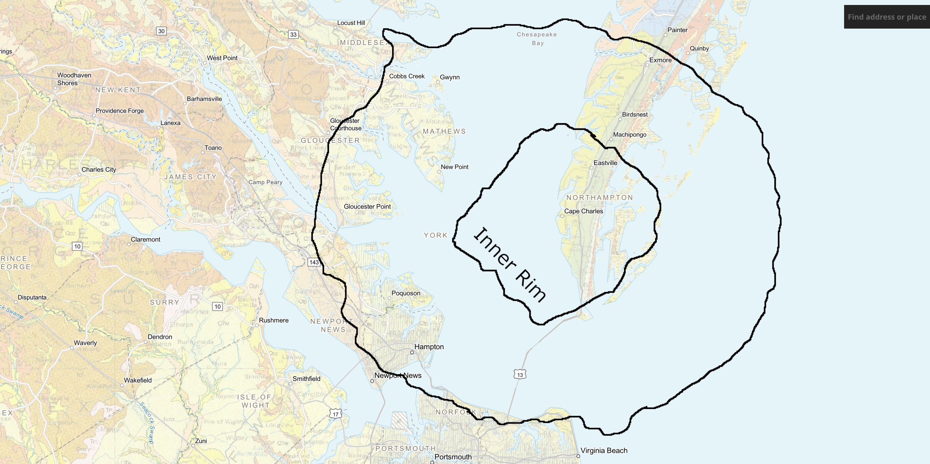
The Anatomy of Annihilation
The crater tells its story in layers. At the center lies a deep inner basin roughly 38 kilometers across, surrounded by a flat-floored terrace-like ring trough edged with collapsed blocks forming ring faults. The entire structure spans about 85 kilometers in diameter and reaches 1.3 kilometers deep - an area twice the size of Rhode Island, and nearly as deep as the Grand Canyon. The bolide was completely vaporized on impact, fracturing the basement rock to great depth and raising a peak ring around the point of impact. The sedimentary walls progressively slumped inward, widening the crater and depositing huge blocks on the trough floor. Rubble and breccia covered everything. The entire event - from initial impact to the settling of the last debris - lasted only hours or days. In geological time, 1.3 kilometers of breccia appeared instantaneously.
Hidden in Plain Sight
For centuries, people lived directly above one of the largest impact craters on Earth's eastern seaboard without the slightest suspicion. The first clue surfaced in 1983 in a drilling core taken off Atlantic City, New Jersey. Geologists found a layer of ejecta containing tektites and shocked quartz grains - unmistakable signatures of a bolide impact. A decade later, in 1993, data from oil exploration finally revealed the full extent of the buried crater beneath the Chesapeake Bay and its surrounding peninsulas. The crater is now recognized as one of the best-preserved "wet-target" impact structures in the world, its features intact beneath millions of years of accumulated sediment. It has been identified as the source of the North American tektite field, including the Georgiaite and Bediasite tektite deposits found hundreds of miles away.
The Crater That Still Shapes Virginia
The impact did not just create a hole - it rewrote the hydrology of the entire region. The continual slumping of rubble within the crater created a long-lasting topographic depression that predetermined the course of local rivers and, ultimately, the location of the Chesapeake Bay itself. When rising sea levels flooded the Susquehanna River valley roughly 10,000 years ago to form the modern bay, the crater's depression guided where the water gathered deepest. For the millions of people who live in the lower Chesapeake Bay area today, the impact carries a more immediate consequence: it disrupted the aquifers. Freshwater aquifers now sit above a deep layer of salty brine - remnants of 100- to 145-million-year-old Early Cretaceous North Atlantic seawater trapped by the impact. This ancient brine makes the entire lower bay region susceptible to groundwater contamination, a problem that shapes water policy to this day.
From the Air
Located at approximately 37.28N, 76.02W, centered beneath the mouth of the Chesapeake Bay near Virginia Beach, Virginia. The crater is entirely buried and invisible from the surface, but the bay itself - shaped by the crater's depression - is the dominant visual feature of the region. From cruising altitude, the funnel-shaped mouth of the Chesapeake between Cape Henry (south) and Cape Charles (north) marks the approximate center of the buried structure. The Chesapeake Bay Bridge-Tunnel is visible crossing the bay mouth. Nearby airports: Norfolk International (KORF) approximately 15 nm to the southwest; Langley AFB (KLFI) to the northwest; Newport News/Williamsburg International (KPHF) to the northwest. Flat coastal terrain with extensive tidal marshes. The Virginia Eastern Shore and Delmarva Peninsula frame the eastern edge of the crater zone.