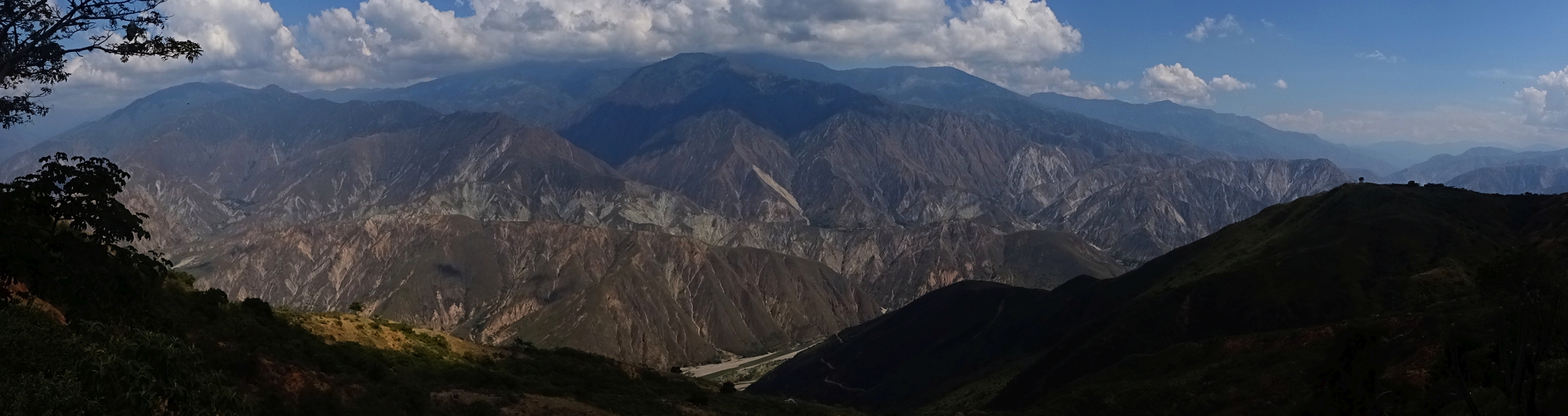
Chicamocha Canyon
The Guane people, who lived along these cliffs long before Spanish boots touched Colombian soil, called the river Chicamocha, a word in their language that translates to "silver thread on a full moon night in the mountain range." Stand at the canyon rim on such a night and the name makes perfect sense. Two thousand meters below, the river catches the light and draws a luminous line through darkness so vast it swallows sound. By daylight, the scale becomes almost incomprehensible: 227 kilometers long, 108,000 hectares in area, walls plunging nearly two vertical kilometers from rim to water. This is the second-largest canyon on Earth, and it has been carving itself deeper for 30 million years.
Written in Stone
The Chicamocha Canyon is a geological textbook laid open. Its flanks expose rock formations spanning nearly the entire history of complex life on Earth, from Precambrian gneiss more than 500 million years old to Pleistocene lake sediments deposited when mastodons roamed the canyon's southern reaches. The canyon began forming during the Early Oligocene, when the Andes were in the violent throes of tectonic uplift. Colliding plates pushed the Eastern Ranges skyward while the Chicamocha River, already ancient, kept cutting downward. Each geological era left its signature in the canyon walls: Cambrian schists named after the canyon itself, Devonian limestones, Jurassic quartzmonzonites, Cretaceous marine formations laid down when this landlocked gorge was seafloor. Near the town of Soata, a paleolake once filled the canyon's southern extension to a depth of 400 meters. Fossils of elephant-like Notiomastodon, giant rodents, and prehistoric deer have been found in the terraces surrounding where that vanished lake once stood.
Between Two Cities
National Route 45A, the main highway connecting Bogota to Bucaramanga, crosses the Chicamocha Canyon between the towns of San Gil and Piedecuesta, and for drivers accustomed to the gentle farmland of the Boyaca plateau, the first glimpse of the canyon's depth comes as a physical shock. The road descends in switchbacks through dry tropical forest, the temperature climbing with each turn as the elevation drops from cold highland to the arid canyon floor at around 900 meters. Heavy truck traffic makes the crossing an adventure in itself, with frequent accidents narrowing a road that was never wide to begin with. San Gil, the adventure tourism capital of Colombia and a fixture on the backpacker trail, sits near the canyon's northern reaches. From there, visitors access whitewater rafting on the Chicamocha River, paragliding launches from the canyon rim, and the trails that wind down into the gorge.
Crossing the Abyss
Since 2006, Chicamocha National Park, known locally as PANACHI, has transformed the canyon from a scenic obstacle on the Bogota-Bucaramanga highway into a destination in its own right. The park's centerpiece is a cable car system that opened in 2009 and quickly became one of Colombia's most popular attractions. The 6.3-kilometer route carries passengers in 39 cabins across the canyon in about 25 minutes, suspended above the void with nothing but air between floor and riverbed. The park offers paragliding, canyoning, ziplining, and an extreme swing that launches riders over the canyon edge, but many visitors come simply to stand at the rim and stare. In 2009, the Chicamocha Canyon was nominated for the New Seven Natural Wonders of the World, ultimately reaching the Top 77. Since 2013, the annual Chicamocha Canyon Race has drawn runners from across the continent to test themselves against the canyon's punishing vertical terrain.
The Seismic Edge
The canyon is not finished with its work. It sits along the southern boundary of the Mesa de Los Santos, one of the most seismically active zones in Colombia, known to geologists as the Bucaramanga Nest, a concentrated cluster of deep earthquakes whose causes remain debated. The same tectonic forces that built the canyon continue to reshape it. Where the Chicamocha River meets the Suarez River south of Zapatoca, the two form the Sogamoso River, carrying the canyon's sediment toward the Magdalena basin and eventually the Caribbean Sea. Fault lines cross-cut the canyon near Jordan, creating the dramatic cliffs that make this landscape so visually striking. The Chicamocha is a living geological process, not a finished monument, and the river that the Guane named for its moonlit beauty continues to deepen the gorge at a pace measured in millimeters per century but visible across millennia.
From the Air
Located at 6.82N, 73.01W in the Santander Department. The canyon is unmistakable from the air: a massive gash in the Eastern Cordillera running northwest-southeast for over 200 km. Palonegro International Airport (SKBG) at Bucaramanga lies approximately 55 km to the northwest. The cable car infrastructure at PANACHI is visible from moderate altitudes. Canyon depths reach 2,000 meters, creating significant turbulence and updrafts. The Bogota-Bucaramanga highway crossing is a useful visual reference point. Best viewed in morning conditions before afternoon convective buildup.