Chimney Rock National Historic Site
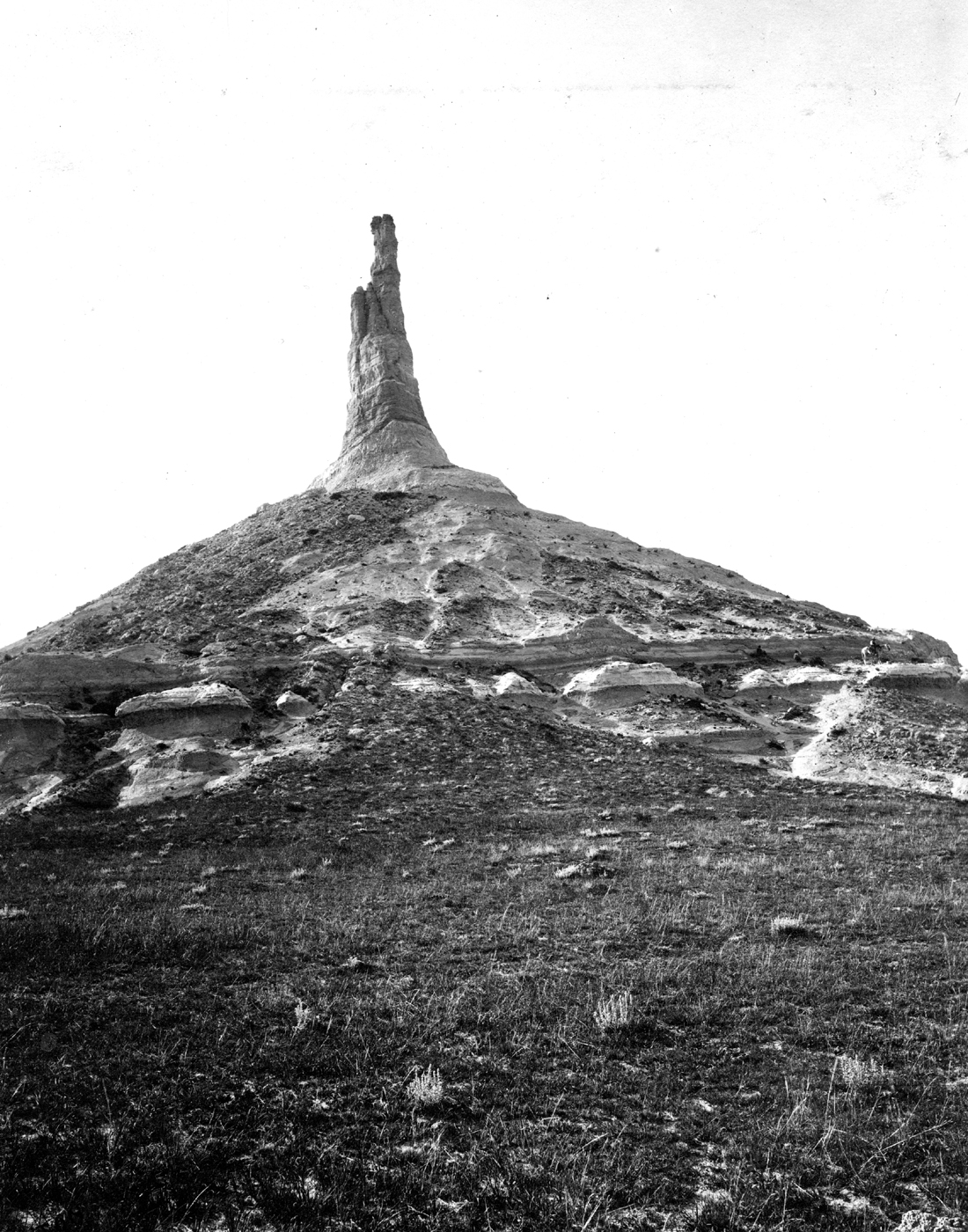
Every American schoolchild learns about the Oregon Trail, but few understand how terrifying it was to cross two thousand miles of unmapped wilderness with only landmarks to guide the way. Chimney Rock provided the reassurance emigrants desperately needed. Rising nearly 300 feet above the North Platte Valley in western Nebraska, this sandstone spire could be seen for days before reaching it, confirming that wagon trains headed to Oregon, California, or Utah were traveling the right direction. More emigrants mentioned Chimney Rock in their diaries than any other landmark on the trail. They described it variously as a chimney, a church steeple, an inverted funnel, or 'unlike anything I had ever seen.' Between 1841 and 1869, roughly half a million people passed this point - one of the largest migrations in human history. The rock still stands, though erosion has shortened it significantly since the pioneer era, and the tracks of wagon wheels still scar the prairie below.
Natural Wonder
Chimney Rock formed from the same Arikaree Group sediments that created the bluffs throughout this region of western Nebraska. What makes it distinctive is simple geology: the rock composing the spire proved harder than the surrounding material, resisting erosion while everything around it weathered away. Millions of years ago, this entire region was part of the High Plains, a relatively flat elevated landscape. Water and wind carved away the softer rock, leaving behind buttes and pinnacles of which Chimney Rock became the most famous. Native Americans used the formation long before European contact, reportedly driving buffalo over the cliffs and calling it something that translated to 'teepee' - suggesting the rock once had a more conical shape. Erosion continues; the spire was taller when pioneers passed than it is today, and lightning strikes have further damaged the soft sandstone.
The Great Migration
The Oregon Trail served as the primary overland route for westward expansion from 1841 until the transcontinental railroad's completion in 1869. Emigrants departed from jumping-off towns along the Missouri River each spring, timing their departure to arrive at mountain passes before snow closed them. The journey to Oregon typically took five to six months, covering roughly 2,170 miles. Death rates were high - perhaps one in ten emigrants died along the way, mostly from cholera and accidents. In this context, landmarks like Chimney Rock provided both navigation and psychological sustenance. After weeks of featureless prairie, the rock's appearance meant progress. Diaries record the excitement: 'We were glad to see this singular natural curiosity,' wrote one emigrant. Another noted that it 'spired to the heavens.' Most parties stopped nearby to camp, rest livestock, and write letters home.
Historical Significance
Chimney Rock entered American consciousness during the great westward migrations and never left. It appeared on Nebraska's state quarter in 2006 - the only geological formation to receive such recognition. The National Park Service designated it a National Historic Site in 1956, and a visitors center opened in 1995 with exhibits on pioneer life and the geology of the region. The site preserves not just the rock but the landscape around it: the gentle terrain emigrants followed, the North Platte River they camped beside, the approach that made the spire visible for miles. Original wagon ruts remain visible in the prairie grass, physical evidence of the wheels that passed here. The museum includes a hands-on covered wagon exhibit and films about the trail's history.
The Landscape Today
Western Nebraska remains remarkably similar to what emigrants encountered. The North Platte Valley provides a wide, relatively flat corridor through otherwise rugged terrain. The surrounding bluffs - including nearby Scotts Bluff National Monument - demonstrate the same erosion processes that created Chimney Rock. The climate is harsh: hot summers, brutal winters, and constant wind across the semi-arid plains. Rattlesnakes inhabit the area; visitors should stay on paved paths near the visitors center. The rock itself cannot be approached - no trails lead to its base - but it dominates the landscape from every viewpoint. Photography works best in the golden light of early morning or late afternoon, when the sandstone glows against the prairie sky.
Visiting the Site
Chimney Rock lies five miles south of Bayard, Nebraska, accessible via State Route 92 and Chimney Rock Road. The visitors center charges modest admission and provides context essential to appreciating what you're seeing. From there, the rock dominates the southern horizon - smaller than emigrants saw it, but still impressive in its isolation. The nearby Chimney Rock Pioneer Crossing campground allows overnight stays at the landmark's base. Scotts Bluff National Monument, twenty-four miles northwest, provides complementary exhibits on the Oregon Trail and offers hiking among similar geological formations. The drive through western Nebraska itself evokes the emigrant experience: mile after mile of open country, the road following the Platte River valley as the wagons did, the landscape vast and humbling in ways that connect modern travelers to those who passed before.
From the Air
Located at 41.70°N, 103.35°W in the Nebraska Panhandle. Chimney Rock is visible from altitude as an isolated spire rising from the North Platte Valley. The surrounding terrain shows the erosional bluffs characteristic of this region. Scotts Bluff is visible 24 miles to the northwest. Western Nebraska Regional Airport (BFF) in Scottsbluff is the nearest commercial airport. Denver International Airport (DEN) lies 180 miles to the southwest. Interstate 80 runs roughly parallel to the North Platte River to the south.