Chiradzulu Mountain
The name means "Yesterday's Tail." According to local folklore, a band of hunters killed a leopard on the mountain but forgot to bring home its tail -- an essential ingredient for the magical rituals that gave chiefs their power. When they returned the next morning to retrieve it, the mountain swallowed them whole. No one ever heard from them again. In the Nyanja language, mchira means "tail" and wadzulo means "yesterday's," and the corruption of those two words gave Chiradzulu its name. The mountain still looms over the Shire Highlands of southern Malawi, third-tallest in the region, shaped like something that might swallow you if you weren't paying attention.
The Man Who Laughs
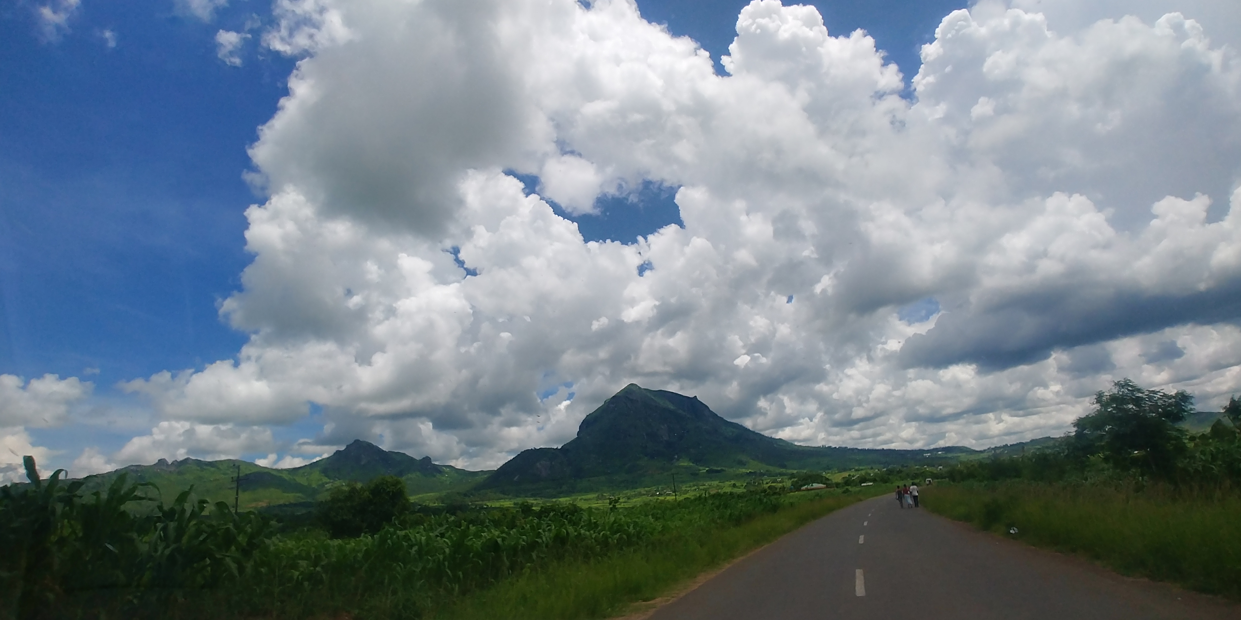
Motorists driving the Blantyre-Zomba Road first spot Chiradzulu from as far away as Mapanga, a silhouette rising from the valley floor that grows larger and more imposing as they approach Njuli. Viewed from the south at a distance, the mountain takes on a shape that has earned it the nickname "Man Mountain" -- it resembles a huge, laughing figure, the peak forming the head, the ridgeline below suggesting the heaving form of a man doubled over in mirth. Geomorphologists attribute this to millennia of faulting activity combined with wind erosion on bare rock outcrops, but the visual illusion is so convincing that tourists have been photographing and remarking on it for generations. The mountain is actually two peaks: Chiradzulu proper, the mightier summit, and Lisawo, its younger sibling, which is the one most visible from the highway. A winding road runs between them, connecting the villages of Mpama to the north with Malika and Lisawo to the south.
Ghosts and Leopards
Chiradzulu's folklore is populated with ghosts. The mountain was said to be full of spirits that exacted vengeance on wayward humans who ventured too deep into its forests, making them vanish from the world of mortals only to be reincarnated as ghosts themselves. The tale of the lost hunters is the most famous of these stories, but it speaks to something real about the mountain's character. Chiradzulu was once covered in thick forest jungle, home to lions, hyenas, leopards, jackals, baboons, monkeys, antelope, and wild pigs. The leopards were particularly fabled -- their tails, in local tradition, carried magical power. But the mountain that once sheltered all this wildlife has been profoundly changed. Overpopulation and poor conservation practices drove the big cats to extinction on the mountain. The forests were felled to supply Blantyre's residents with charcoal, leaving bare slopes where dense canopy once stood.
A Colonial Plateau
Between the twin peaks, the road passes through a plateau-like plain where the British colonial government established an administrative settlement. This outpost, complete with offices, a tourist information centre, and staff accommodation, became the administrative heart of the Chiradzulu District that took its name from the mountain. The Chiradzulu Mountain Forest Reserve was established in 1924, protecting 774 hectares, though the reserve's boundaries could not prevent the broader deforestation that would strip much of the mountain bare over the following century. The colonial presence left its mark in other ways, too. Chiradzulu District sits approximately 20 kilometres northeast of Blantyre, Malawi's main commercial centre, and the mountain serves as a constant landmark for travellers moving between Blantyre and Zomba. It is the third-highest peak in southern Malawi, after the Mulanje Massif with its Sapitwa peak and the Zomba Plateau.
Making the Mountain Green Again
In 2024, residents of two settlements on the mountain -- Dokotala and Nkupu -- decided to act where decades of policy had failed. They began replanting trees, creating a rare wooded area on slopes that had been stripped clean. Volunteers organized a fire-watch system: when a blaze starts, the community is notified so they can intervene before it becomes a wildfire. The reforestation effort carries a layer of meaning beyond ecology. The area holds the graves of people who died from leprosy, and the community regards their tree-planting work as an act of honour toward those who are buried there. Whether the big cats will ever return is doubtful. But Chiradzulu's forests, the ones that once hid leopards and swallowed hunters, are tentatively coming back -- planted not by colonial decree or government program, but by the people who live on the mountain and have decided it should be green again.
From the Air
Located at 15.68°S, 35.18°E in the Shire Highlands of southern Malawi, approximately 20 km northeast of Blantyre. The twin-peaked mountain is a prominent terrain feature visible from the Blantyre-Zomba Road. Nearest major airport is Chileka International Airport (FWCL) in Blantyre. Elevation varies; the mountain is the third-highest peak in southern Malawi. Watch for mountain weather conditions and maintain safe altitude. Clear conditions typical in the dry season (May-October).