Chitrakote Falls
During monsoon, when the Indravati River runs full and angry, the water spills over a horseshoe lip nearly 300 meters wide and drops 30 meters into a churning semicircular pool. Mist rises in thick columns, and where the afternoon sun strikes the spray, rainbows materialize between July and October as reliably as the rains themselves. Chitrakote Falls is the widest waterfall in India, and the horseshoe shape that gives it this distinction has inevitably drawn comparisons to Niagara, though at roughly one-third Niagara's width, the scale is different. What Chitrakote offers instead is solitude, a thundering spectacle in the remote forests of Chhattisgarh's Bastar district, where local boatmen paddle beneath the spray and pilgrims bathe in the calmer water downstream.
A River's Long Journey to the Edge
The Indravati River originates in the Kalahandi district of Odisha, on the western slopes of the Eastern Ghats, and flows westward across the plateau before reaching Chitrakote, about 38 kilometers west of Jagdalpur. Here the river encounters a geological transition: the quartzitic sandstone of the upper valley gives way to Archaean granite and gneisses, and the softer rock has eroded into the horseshoe gorge that defines the falls. After the plunge, the Indravati continues westward through the Bodhghat forest before eventually joining the Godavari River at Bhadrakali, having traveled approximately 240 miles through the state. The geological significance of Chitrakote extends beyond its beauty: it is one of six waterfalls in India classified as geomorphosites, geoheritage sites recognized for their geological and geomorphological value by institutions including UNESCO and the International Union for Conservation of Nature.
Three Braids and a Horseshoe
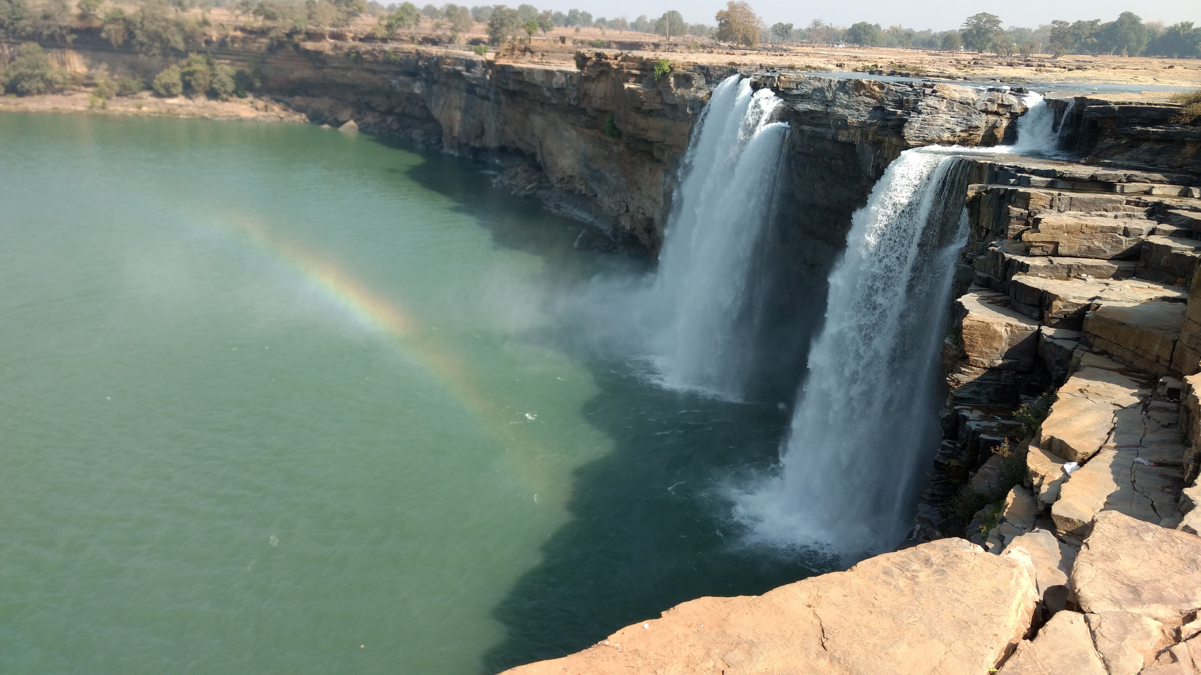
In the dry season, from roughly November through June, Chitrakote splits into three distinct braids of falling water separated by exposed rock faces. Each braid has its own character, and pools form in the upstream riverbed where paddle boats navigate the shallow water above the drop. But when the monsoon arrives, the transformation is complete: the three braids merge into a single continuous sheet of whitewater that covers the entire horseshoe from left bank to right, a curtain of falling water nearly 300 meters across. The pond at the base fills to a stormy churn where adventure boats fight the current, while calmer sections along the edges become bathing areas for pilgrims. At sunset, the spray catches the light at precisely the angle needed to set the mist on fire with color.
Shrines in the Spray
On the left bank of the falls, a small Hindu shrine dedicated to Shiva sits above naturally formed grottoes called the Parvati caves, named after Shiva's wife. Climbing down a rock ledge leads to a niche housing stone slabs carved with deities, and nearby a small straw hut shelters images of Shiva and his son Ganesha, their surfaces rusted by years of moisture from the falls. Fishing remains a livelihood for local people in the pools and river stretches near Chitrakote. The sacred and the practical have coexisted here for generations, the shrine drawing devotees while the river feeds families. Chitrakote Falls lies near Kanger Valley National Park, sharing the broader Bastar landscape with Tirathgarh Falls, the park's other major waterfall about 38 kilometers from Jagdalpur.
A Waterfall Under Pressure
The Indravati River that makes Chitrakote possible is not what it once was. Water diversion through Jaura Nallah near the Odisha-Chhattisgarh border by the Odisha government, combined with the construction of check dams upstream, has dramatically reduced the river's flow. During summer months from April to June, the falls have dried up entirely. Social activists and environmentalists have campaigned to restore the Indravati's flow, but progress has been slow against the competing demands of irrigation and hydroelectric power. Multiple large power plants operate on the river upstream, and a 7.5 MW plant has been planned specifically to harness the head at Chitrakote. The irony is sharp: the same waterfall that the Indian government's Ministry of Tourism assessed in 2003 as having exceptional ecotourism potential now flows reliably only during the rain.
Getting to India's Hidden Niagara
Chitrakote sits in a region that tests the commitment of its visitors. Jagdalpur, 38 kilometers to the east, serves as the gateway, and a government-run hotel perches at the top of the falls with steps descending through a garden to the viewing areas. Log huts with both basic and modern cabins offer accommodation with views of the gorge. But Bastar's remoteness cuts both ways. In 2008, when President Pratibha Patil visited Chitrakote Falls, Maoist insurgents attacked a police vehicle in the area, a reminder that this landscape of extraordinary natural beauty sits within India's most conflict-affected region. Infrastructure has improved since the government drew up ecotourism plans, with better roads and signage from Jagdalpur, but Chitrakote remains far from the tourist circuits that serve India's better-known natural attractions.
From the Air
Chitrakote Falls (19.21N, 81.70E) is located on the Indravati River approximately 38 km west of Jagdalpur in Bastar district, Chhattisgarh. From the air, the horseshoe-shaped gorge is a distinctive landmark, especially during monsoon when the falls span nearly 300 meters. The Indravati River's westward course through relatively flat terrain makes the sudden gorge visible as a break in the landscape. The nearest airport is Maa Danteshwari Airport, Jagdalpur (VEJP). During monsoon (July-October), mist from the falls may be visible from altitude. The surrounding area is a mix of forest and agricultural land with limited development.