Christmas Island National Park
Every year, sometime after the first rains of October, the forest floor begins to move. One hundred million Christmas Island red crabs emerge from their burrows and march toward the coast in a migration so dense it closes roads, blankets cliffs, and turns the jungle crimson. This spectacle -- one of the greatest wildlife events on the planet -- takes place on an island where nearly two-thirds of the land is national park, a 85-square-kilometer sanctuary perched atop an ancient seamount in the Indian Ocean, 500 kilometers south of Java.
Born from Phosphate and Protest
Christmas Island National Park exists because of a bird. In the early 1970s, growing alarm over phosphate mining's impact on the island's wildlife focused attention on Abbott's booby, a seabird that nests nowhere else on Earth. The species' survival depended entirely on the tall rainforest canopy of Christmas Island, the same canopy that mining operations were steadily clearing. Conservation pressure built through the decade, and by 1980 the park was formally established. Today it covers approximately 85 square kilometers -- 63 percent of the island -- and its boundaries extend 50 meters beyond the low water line, protecting 46 of the island's 73 kilometers of shoreline. What began as a campaign to save one bird ended up preserving an entire ecosystem.
An Island of Endemics
Christmas Island sits atop an undersea mountain surrounded by the abyssal zone, and that deep-water isolation has turned the island into an evolutionary laboratory. The Christmas Island frigatebird, critically endangered, breeds here and almost nowhere else. Abbott's booby remains exclusive to these forests. The isolation that produced these species also shaped the land-dwelling community: there may be as many as one million coconut crabs on the island, making it one of the densest populations of the world's largest land invertebrate. Several species of hermit crab scuttle through the undergrowth alongside grapsid crabs. Even the plants surprise -- a stand of mangroves, species normally found in coastal estuaries, grows at Hosnies Spring some 50 meters above sea level, far from any tidal influence.
The Crazy Ant Invasion
The park's greatest threat arrived on tiny legs. Yellow crazy ants, an invasive species with no native ant competitors on the island, formed supercolonies of extraordinary density. Swarms of the ants have been documented overwhelming red crabs more than a hundred times their combined biomass, spraying formic acid to kill them. The ecological cascade is devastating: without red crabs to clear the forest floor of leaf litter, the entire understory changes. The park's 2002 management plan listed control of the yellow crazy ant as its single highest priority. A staff of 17, working from an office in Drumsite on the island's northern side, manages the park's response -- a small team facing an invasion measured in billions of individual ants spread across a dense tropical landscape.
The Crimson March
The red crab migration remains the park's defining spectacle. Triggered by the onset of the wet season, usually in October or November, the crabs leave their forest burrows and travel to the coast to breed. Roads are closed or fitted with special crab underpasses. Park rangers monitor the migration's progress, timing closures to the crabs' movements. Females release their eggs into the ocean at the turn of the high tide, and weeks later, tiny crab larvae wash ashore to begin the journey back inland. The sheer scale -- roughly 100 million crabs moving in synchronized waves across the island -- makes it one of the most visually overwhelming natural events anywhere, a living river of red flowing downhill through rainforest and across roads to the sea.
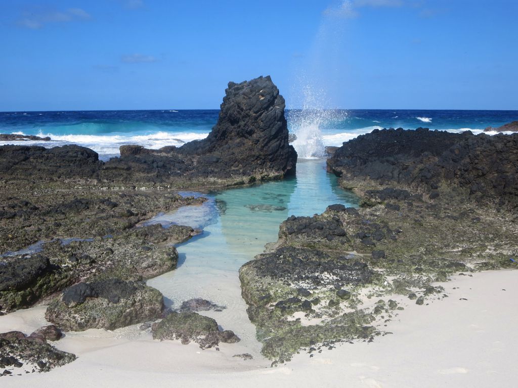
Cliffs, Caves, and Deep Water
From the air, Christmas Island presents as a forested plateau ringed by steep limestone cliffs that drop straight to the ocean. There are no gentle harbors here -- the coastline is an almost continuous sea cliff, broken only by a few shallow bays with coral shingle and sand beaches. Beneath the waterline, the seamount plunges into oceanic depths, creating underwater walls that attract pelagic fish, whale sharks, and manta rays. The park's marine boundary captures just a sliver of this vertical ecosystem, but it is enough to protect the coral communities and seabird feeding grounds that make the island's biology possible. Above and below the waterline, Christmas Island is a place defined by edges -- cliffs meeting ocean, forest meeting sky, and one of the most isolated ecosystems on Earth meeting the forces that threaten to unravel it.
From the Air
Located at 10.48S, 105.63E in the Indian Ocean, approximately 500 km south of Java. The national park covers 63% of the island and is visible as dense tropical rainforest covering a raised plateau surrounded by steep coastal cliffs. Flying Fish Cove, the island's only port, sits on the northeast coast. Nearest airport: Christmas Island Airport (YPXM). Recommended viewing altitude 3,000-6,000 ft to appreciate the contrast between the forested interior and the sheer cliff coastline. During migration season (Oct-Feb), the red crab movement may be visible as reddish patches on roads and clearings.