Cilgerran Castle
J. M. W. Turner painted Cilgerran Castle at least three times. Each painting hangs in the Tate: the hazy sunrise version, the upstream view, the mountain scene at evening. David Cox painted it. George Barret painted it. Anonymous artists painted it. For a castle that was abandoned by 1400 and has been crumbling ever since, Cilgerran has been extraordinarily good at holding the attention of people with brushes. The reason is the setting. Two massive drum towers rise from a rocky promontory above the River Teifi, backed by nothing but cliff and sky -- a composition so naturally dramatic that artists have been unable to resist it for over two centuries.
A Castle That Would Not Stay Conquered
Gerald of Windsor built the first castle here around 1110, little more than a wooden palisade on a cliff above the Teifi. It was a strategic site near Cardigan, and strategic sites in medieval Wales attracted violence. Rhys ap Gruffydd took Cardigan Castle in 1165, then turned on Cilgerran and destroyed it entirely. In 1204, William Marshal, 1st Earl of Pembroke, recaptured the site and drove out Rhys's son Maelgwn ap Rhys. Marshal began repairs, but they proved inadequate: in 1215, Llywelyn the Great took the castle after just a single day's battle. It was the Marshal family -- specifically William Marshal the younger, 2nd Earl of Pembroke -- who finally built the stone castle that visitors see today, beginning after 1223. The site changed hands between English and Welsh forces so many times in the 12th and 13th centuries that permanence must have seemed like an absurd ambition.
Drum Towers on the Cliff
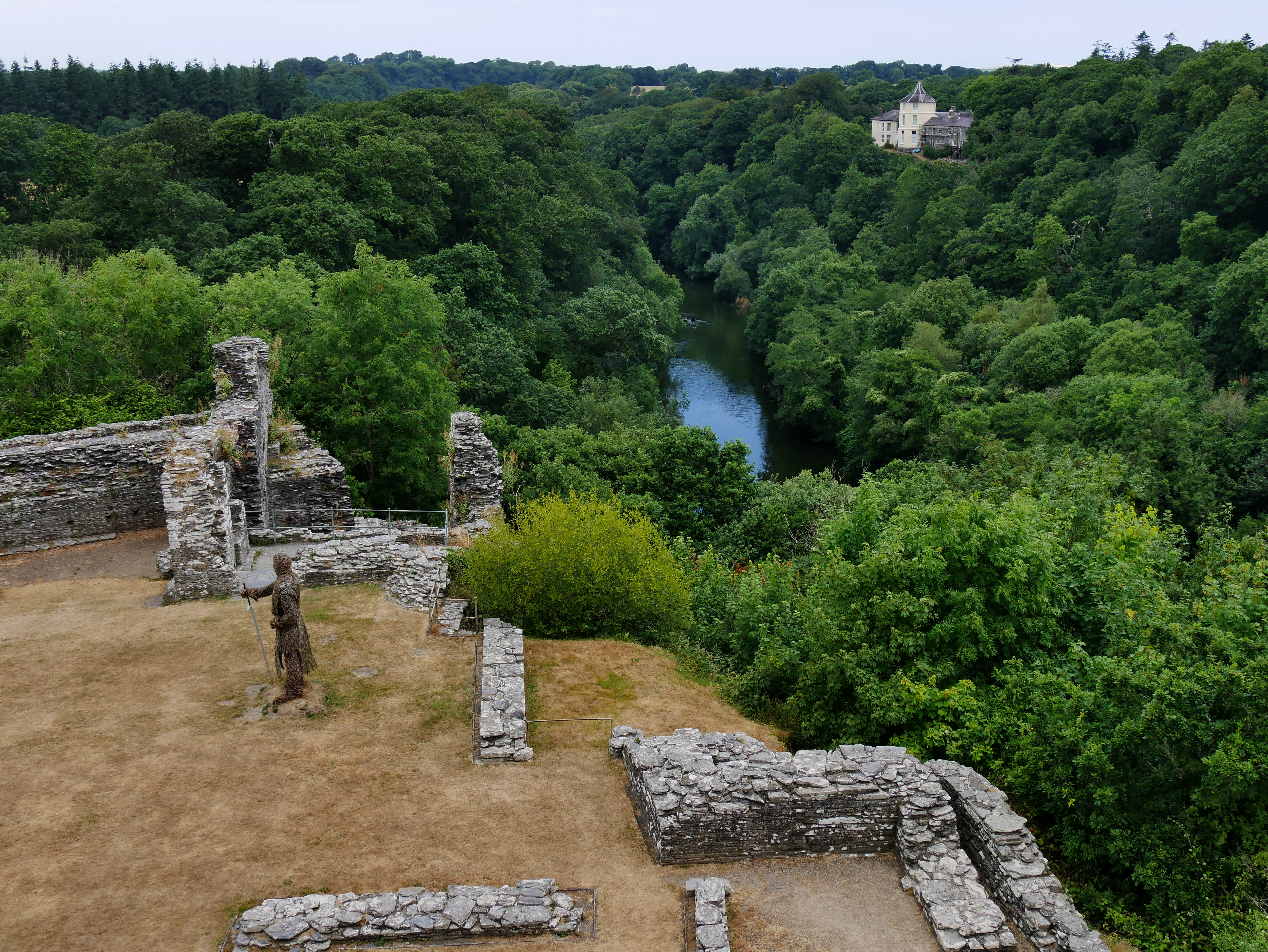
What the Marshals built was distinctive. Rather than a central keep -- the typical design of the period -- Cilgerran relied on a pair of massive drum towers as its primary defence. The castle sits on a rocky promontory with one side directly onto a cliff face, so the engineers concentrated their fortifications on the inland approach, where attackers would actually come from. Two lines of defence protected the interior: an outer bailey and the twin towers, connected by curtain walls. The gatehouse stood at the southeast, once spanned by a pivoting bridge. The castle is the most northerly in Pembrokeshire and is twinned with Cardigan Castle, visible on the opposite bank of the Teifi three miles downstream. From the towers, you can still walk down to the river -- the same river that once made this promontory worth fighting over.
Decline and the Painters' Discovery
After passing through the de Cantilupe and Hastings families, Cilgerran was allowed to decay. By 1387 it was in ruins, and by 1400 it was thought to be deserted, though ownership continued to pass through the Earls of Pembroke to Jasper Tudor, Duke of Bedford. The 19th century brought further indignity: the dry ditch of the bailey was converted into the village pound, and in 1863 a section of the curtain wall collapsed due to slate quarrying nearby. But ruin proved to be the castle's salvation as an image. The Romantic painters found in Cilgerran exactly what they craved -- a brooding medieval ruin in a wild landscape, towers silhouetted against weather, the river flowing indifferently below. Turner's multiple versions testify to an obsession, not merely an interest.
National Trust and Living History
In 1938, Cilgerran Castle was presented to the National Trust, which now maintains the site in partnership with Cadw. The two substantial towers still stand, their proportions remarkably intact despite six centuries without a roof. Entry is free. In 2015, the castle hosted a re-enactment of the Battle of Agincourt to mark the 600th anniversary -- an odd choice of battle for a Welsh castle, perhaps, but the site has never been particular about whose history it accommodates. From the ramparts, the River Teifi curves away through a wooded gorge that has changed little since Gerald of Windsor first saw a defensive opportunity in the cliff. The artists saw something different in the same view: not strategy, but beauty. Both readings have outlasted the garrison.
From the Air
Located at 52.06N, 4.63W on a promontory above the River Teifi in Pembrokeshire, near Cardigan. The twin drum towers are visible from the air. Nearest airports: Haverfordwest (EGFE) 20nm southwest, Aberporth (EGFA) 10nm south. Best viewed at 1,500-2,500ft AGL. Cardigan Castle is visible 3 miles downstream on the opposite bank.