Cinder Cone and the Fantastic Lava Beds
For over a hundred years, geologists argued about when Cinder Cone erupted. Some swore it happened in 1851, pointing to supposed eyewitness accounts and trees that seemed too young. Others insisted the volcano was centuries older. The answer came not from written records or tree rings, but from the Earth's own magnetic signature locked in cooling lava. In northern California's Lassen Volcanic National Park, this nearly perfect cinder cone rises above a landscape so otherworldly that early explorers named the surrounding flows the Fantastic Lava Beds.
The Great Debate
The mystery began in the 1870s, when geologist Harvey Harkness described Cinder Cone and noted that many locals believed it had erupted within living memory. The volcano's remarkably fresh appearance seemed to support this claim. In the 1930s, USGS volcanologist R. H. Finch studied tree rings showing periods of slow growth and concluded there had been multiple eruptions spanning nearly 300 years, with the final lava flow emerging in 1851. His detailed chronology became the accepted scientific consensus for decades. But Finch's work rested on assumptions that would later crumble. The purported 1851 eyewitness accounts proved unreliable. More importantly, scientists eventually realized they could test the volcano's age using a clock buried in the rock itself: the Earth's magnetic field orientation preserved when molten lava solidifies.
Magnetic Truth
The breakthrough came after Mount St. Helens erupted in 1980, prompting the USGS to reassess volcanic hazards throughout the Cascade Range. Scientists studying Cinder Cone discovered that the magnetic orientation recorded in all five lava flows was identical, meaning they could not have been erupted decades apart as Finch proposed. The magnetic signature also differed from what the Earth's field looked like in the 1850s, ruling out an eruption during that decade entirely. Carbon-14 dating of trees killed by the eruption finally pinned down the date: sometime between 1630 and 1670. The entire sequence of eruptions, building the cone and spreading the lava beds, occurred during the mid-17th century in what was likely a single continuous event lasting less than 50 years.
A Landscape Transformed
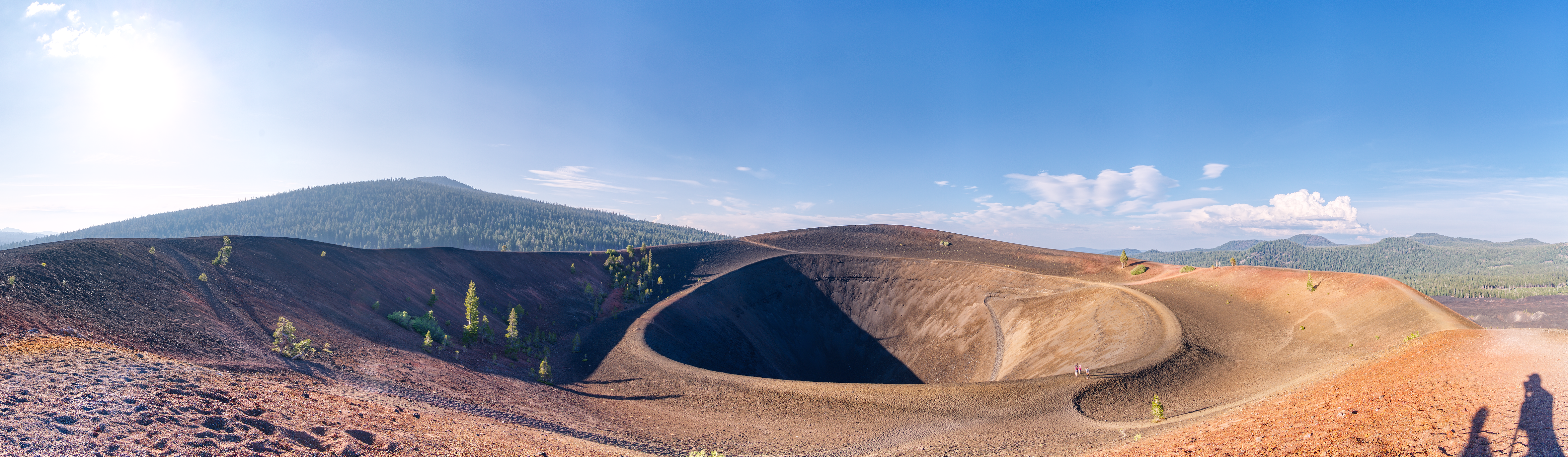
When Cinder Cone erupted in the 1650s, it reshaped the surrounding terrain. Five separate lava flows, composed of basaltic andesite and andesite, poured from the volcano's base. These dark, rugged flows spread northeast and southwest, damming creeks and creating two lakes: Snag Lake to the south and Butte Lake to the north. Today, water from Snag Lake still seeps through the porous lava beds to feed Butte Lake. The flows earned their evocative name from their strange, broken surface of blocky lava that appears almost lunar. Concentric craters crown the summit, with diameters ranging from the inner crater to the broader outer rim. Standing atop the cone, visitors can gaze across unvegetated expanses of dark rock that look unchanged since the day they cooled.
The View from Above
Cinder Cone offers one of the best volcanic vantage points in the Cascades. From its summit, the view sweeps across the Fantastic Lava Beds to Brokeoff Mountain, Lassen Peak, and Chaos Crags. The cone itself is textbook perfect, built from loose volcanic cinders and ash before being snuffed out by its own lava flows. This sequence represents the classic cinder cone life cycle: explosive eruptions pile up loose material, then fluid lava breaks through at the base, ending the explosive phase. The cone rises prominently above the surrounding area and spread ash across the landscape during its brief but violent birth. Nearby, the historic Nobles Emigrant Trail skirts Snag Lake and follows the edge of the lava beds, a route 19th-century travelers used to reach California's Sacramento Valley.
From the Air
Located at 40.55N, 121.32W in the northeastern section of Lassen Volcanic National Park. The cone and surrounding black lava beds are highly visible from altitude, contrasting sharply with the surrounding green forest. Best viewed from 5,000-8,000 feet AGL. Nearby airports include Redding Municipal (KRDD) approximately 50nm to the west. The Fantastic Lava Beds appear as dark, unvegetated patches surrounding the symmetrical cone. Butte Lake and Snag Lake are visible landmarks on the northeast and southwest sides of the lava flows respectively.