Cinque Terre National Park
In 1951, about 3,500 acres of Cinque Terre were under cultivation. Today, the figure is 275. The numbers tell a story that the postcard views do not: these five villages clinging to the Ligurian coast are a landscape engineered by human labor over centuries, and when that labor stopped, the land began to fall apart. Cinque Terre National Park -- Italy's smallest at 4,300 acres, but its most densely populated with 5,000 permanent residents -- exists to manage a paradox. The terraced hillsides that make the place beautiful need the farming that tourism replaced.
Five Villages, One Coastline
From west to east they line up along the rugged Ligurian coast: Monterosso al Mare, Vernazza, Corniglia, Manarola, and Riomaggiore. Each village occupies a cleft in the cliffs where a stream meets the sea, the buildings stacked vertically in the narrow ravines, painted in the sun-faded pastels that have become synonymous with the Italian Riviera. Corniglia sits uniquely high -- 100 meters above the water, reachable only by a staircase of 382 steps called the Lardarina or by a winding road through the hills. These are not resort towns that grew to meet demand. They are fishing and farming communities whose cramped medieval layouts reflect the topography that made flat ground a luxury.
The Architecture of Terraces
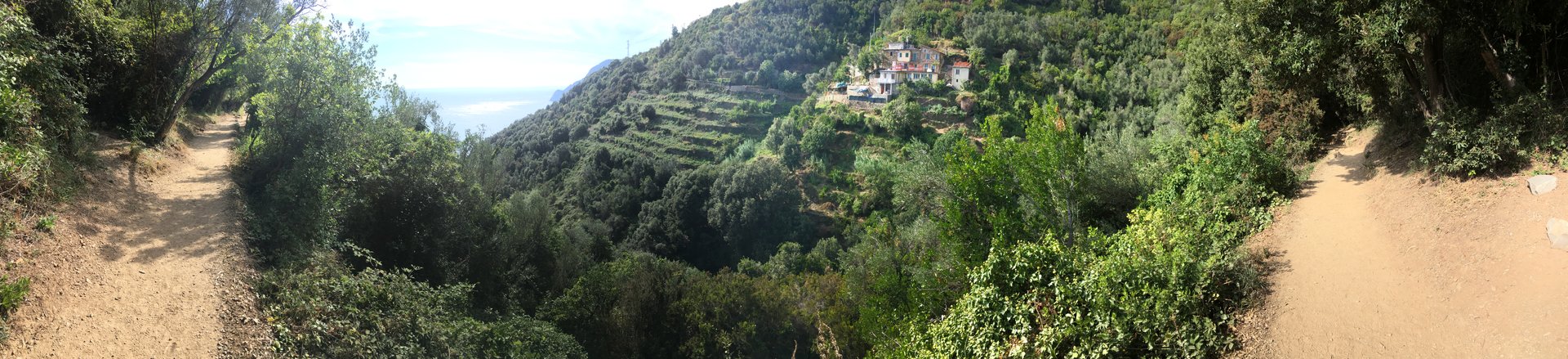
The defining feature of Cinque Terre is not its colorful buildings but the stone terraces that climb the mountainsides behind them. Built over centuries without mortar, these dry stone walls transformed impossibly steep slopes into narrow strips of arable land. Grapevines planted on these terraces produced the wines -- Albarola and Vermentino varieties -- that gave Cinque Terre a reputation as wine country in the Middle Ages. The terraces also functioned as engineering: they controlled drainage, prevented erosion, and stabilized the slopes against the landslides that geography makes inevitable along this coast. When farmers abandoned the terraces in the 1960s as tourism became the easier livelihood, the consequences were predictable. Comparison of aerial photographs from 1958 and 2000 shows dramatic soil erosion and terrace degradation across the region.
The Floods of 2011
On 25 October 2011, four hours of extraordinary rainfall -- 22 inches in a single afternoon -- triggered flash floods that virtually destroyed the towns of Monterosso al Mare and Vernazza. Mud, debris, and water tore through streets that had channeled mountain runoff for centuries. The other three villages, thanks to their natural topography and functioning drainage systems, escaped largely unscathed. The disaster underscored what scientists had been warning: decades of terrace abandonment had left the slopes vulnerable. Without the stone walls to slow water and hold soil, the mountains shed their surface like a wet coat. The national park, established in 1999, had already identified terrace restoration as its primary mission, but the floods made the urgency impossible to ignore.
The Park of Man
UNESCO added Cinque Terre to its World Heritage List in 1997, describing the site as 'the harmonious interaction between people and nature to produce a landscape of exceptional beauty.' The Cinque Terre National Park, founded two years later, calls itself 'the park of Man' -- a deliberate acknowledgment that this is not wilderness to be preserved but a human creation to be maintained. The park's central project, the 'Uncultivated Lands' LIFE initiative co-founded with the European Community in 2001, works to reclaim abandoned terraces and replant traditional grape varieties. A pilot hillside called Corniolo serves as both laboratory and classroom, where researchers develop safe cultivation practices for slopes that can exceed 45 degrees. The marine area off the coast, protected since 1997, is divided into three zones of decreasing restriction, from strict nature reserves where boats are prohibited to areas allowing monitored recreational fishing. Five Marian sanctuaries, one linked to each village by footpath, date from the Middle Ages -- the oldest, Nostra Signora de Soviore, appears in records from 1225.
From the Air
Located at 44.10N, 9.75E along the Ligurian coast of northwestern Italy. The five villages are visible as clusters of colorful buildings in steep coastal ravines, connected by the coastal rail line whose tunnels are visible from lower altitudes. The terraced hillsides create a distinctive stepped pattern on the mountain slopes. Nearest airport is Genova-Sestri (LIMJ) approximately 80 km northwest. La Spezia naval base is visible to the southeast. The coastline runs roughly northwest-southeast with mountains rising steeply from the shore.