Ciudad Perdida
A family of treasure hunters shot a wild turkey in the jungle. When they went to retrieve it, they noticed the bird had landed on a series of stone steps rising up the mountainside. They climbed. At the top, they found an abandoned city swallowed by vegetation -- terraces, plazas, tiled roads, all carved into a ridge of the Sierra Nevada de Santa Marta. The year was 1972. The Sepulveda family named the place "Green Hell." The Kogi people, descendants of the Tairona civilization that built it, had always called it Teyuna. The rest of the world would come to know it as Ciudad Perdida -- the Lost City.
Older Than Machu Picchu
Ciudad Perdida is believed to have been founded around 800 AD, making it roughly 650 years older than Machu Picchu. The Tairona people carved 169 terraces into the mountainside, connected them with a network of tiled roads, and built circular plazas that served as gathering points for a population estimated between 2,000 and 8,000 people. The city functioned as a political and manufacturing center, part of a broader network of settlements scattered across the Sierra Nevada. Only about 30 to 40 percent of similar sites in the region have been explored, and recent lidar surveys continue to reveal new ones beneath the canopy. What has been uncovered suggests a civilization far more complex and extensive than early archaeologists imagined.
Gold on the Black Market
The Sepulvedas' discovery did not lead to careful archaeology. It led to looting. Gold figures and ceramic urns from the terraces soon appeared on the black market in nearby towns. Rival groups of treasure hunters fought over access to the site, and violence followed -- one of the Sepulveda sons was murdered there. Archaeologists from the Colombian Institute of Anthropology and History arrived in 1976 to begin formal excavation, but the damage from four years of uncontrolled plundering had already scarred the site. What remains is still extraordinary, but the story of Ciudad Perdida's rediscovery is inseparable from the greed that nearly destroyed it a second time.
The People Who Never Left
The Kogi, Arhuaco, Kankuamo, and Wiwa people -- all descendants of the Tairona -- never truly lost the city. Members of these communities have stated that they visited Teyuna regularly long before the Sepulvedas stumbled upon it, but kept quiet. For them, the city is not a ruin. It is a sacred site, the heart of a network of villages their ancestors inhabited. Since 2009, the Global Heritage Fund has worked alongside these indigenous communities as major stakeholders in preservation efforts, recognizing that the people with the deepest claim to the site are also its most committed guardians. The relationship between archaeologists, tour operators, and indigenous communities remains a negotiation -- one that shapes who tells Ciudad Perdida's story and on whose terms.
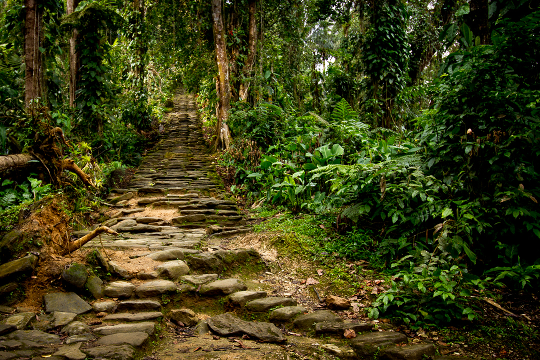
Twelve Hundred Steps Through the Jungle
Reaching Ciudad Perdida requires a multi-day trek that begins from the town of Machete Pelao, accessible by four-wheel-drive vehicle from Santa Marta on the Caribbean coast. The trail winds through dense rainforest, crosses rivers, and climbs mountain ridges before arriving at the famous 1,200 stone steps that ascend to the city. The Colombian Army patrols the route, a precaution rooted in the area's difficult recent history -- in 2003, the ELN guerrilla group kidnapped eight foreign tourists here, holding them for three months. Since hikes resumed in 2005, there have been no further incidents. The trek is physically demanding, often muddy, and entirely worth it. At the top, the terraces emerge from the green like something the jungle agreed to give back, reluctantly and not all at once.
From the Air
Located at 11.04N, 73.93W in the Sierra Nevada de Santa Marta, Colombia, at approximately 900-1,300 meters elevation. The site is buried in dense jungle canopy and not directly visible from altitude, but the Sierra Nevada massif -- the world's highest coastal mountain range, peaking at 5,775 meters -- is an unmistakable landmark from any approach. Nearest airport: Simon Bolivar International Airport (SKSM) in Santa Marta, approximately 40 km to the northwest as the crow flies. The trek to the site begins roughly 2-3 hours by road from Santa Marta.