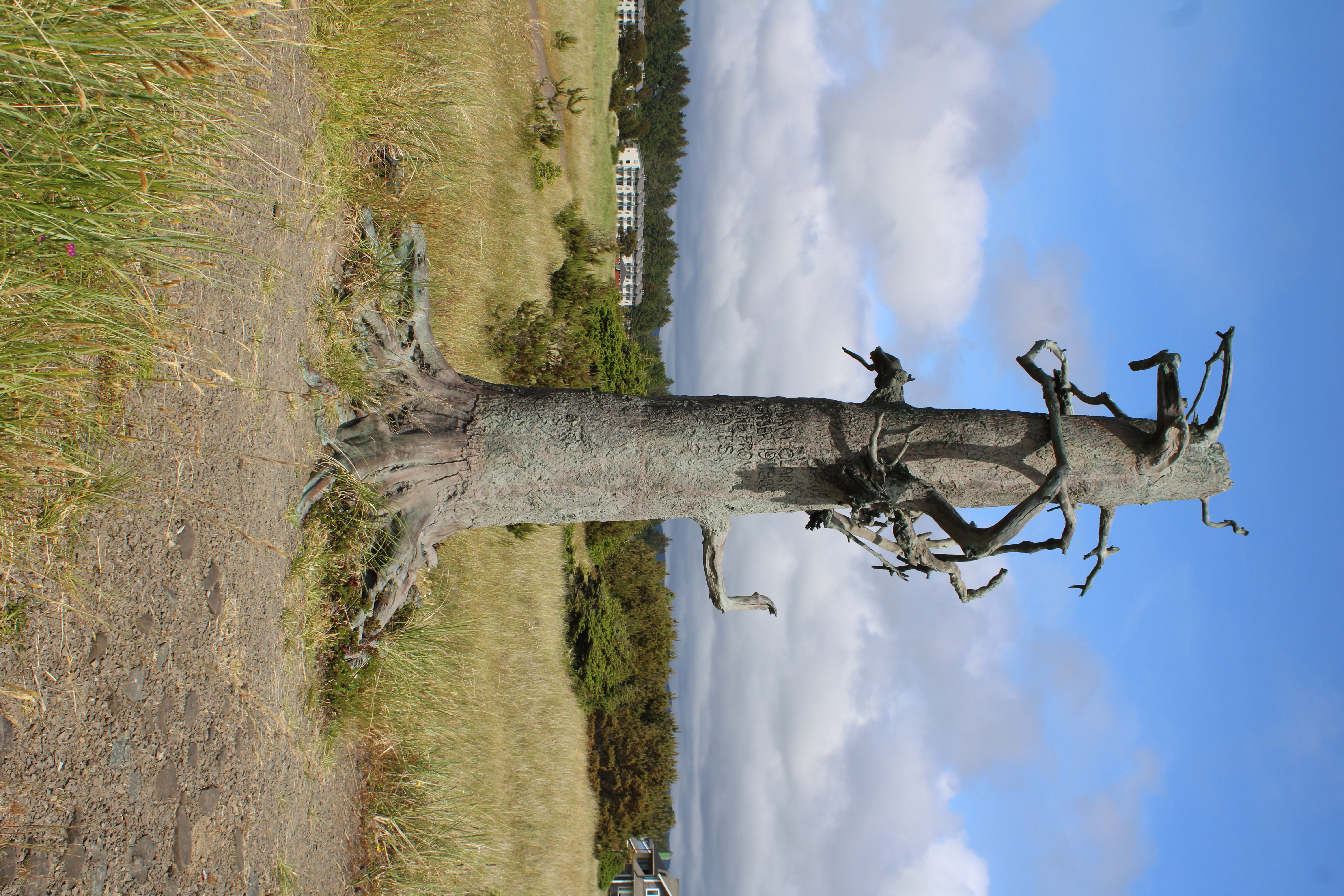
Clark's Tree
"William Clark. November 19, 1805. By land from the U. States." Eleven words, carved into a small pine tree on a windswept beach, and an entire continent's worth of ambition compressed into a single act of vandalism. Clark and eleven men had walked north along the ocean from their camp near present-day Ilwaco, four miles through wet sand, to reach this stretch of coast on Washington's Long Beach Peninsula. The carving was not art. It was a claim -- the westernmost, northernmost mark the Lewis and Clark Expedition would leave on the Pacific shore. The tree is long gone, probably removed by a road crew decades later without anyone realizing what it carried. But a 20-foot bronze sculpture now stands on a dune above the beach at Breakers, remembering both the man and the moment.
Eleven Men and a Knife
By November 1805, the Corps of Discovery had been traveling for over a year and a half. They had crossed the Great Plains, navigated the Missouri, hauled canoes over the Bitterroot Mountains, and descended the Columbia River through rapids that nearly killed them. When Clark's small party reached the Pacific beach near present-day Long Beach, the moment was less triumphant than exhausted. Rain fell constantly. Their leather clothing was rotting. The men were living on dried fish and roots traded from the Chinook people who had lived along this coast for thousands of years. Clark carved his inscription into a living pine -- not on a cliff face or a prominent landmark, but on a modest tree near the dunes. It was a practical act in a practical tradition: explorers marked trees to establish precedence of discovery, and Clark was staking the young republic's claim to the Oregon Country. The spot he chose was the farthest northwest the expedition would venture before turning south to build Fort Clatsop for the winter.
Bronze on a Barge
Stanley Wanlass, a sculptor educated at Brigham Young University, spent years creating a memorial worthy of the moment. His bronze depicts the tree as it might look two centuries after Clark's visit -- ancient, knurled, windblown, still clinging to life. The sculpture was cast in Clarkston, Washington, a city named for the same explorer, near the confluence of the Snake and Clearwater Rivers where Lewis and Clark had built canoes for their descent to the Pacific. Getting the finished bronze from Clarkston to Long Beach became its own expedition. In 2003, the sculpture was loaded onto a barge and floated down the Columbia River, retracing part of the expedition's route in reverse. It stopped for public viewing in Richland, Hood River, Portland, and Vancouver before passing into the Pacific Ocean for the final leg to Long Beach. According to Wanlass, the sculpture was nearly lost at sea during the ocean crossing -- a bronze monument to frontier ambition almost swallowed by the same waters Clark had journeyed so far to reach.
Two Markers, Two Centuries
Clark's Tree is not the first memorial on the Long Beach Peninsula to honor the expedition. In 1932, a marker bearing the same name was erected at 3rd and Pacific in Long Beach's downtown, well before the exact site of Clark's carving was identified with confidence. The newer sculpture sits closer to the actual location, on a dune above the beach near the old Breakers resort area, part of the 8.5-mile Discovery Trail that traces Clark's route from Baker Bay on the Columbia to the ocean beach. Walking the trail today, the landscape is remarkably similar to what Clark would have seen: low dunes, salt grass, and a flat expanse of hard-packed sand stretching north and south. The Long Beach Peninsula is a narrow spit separating the Pacific from Willapa Bay, and its open, wind-scoured character has resisted the kind of development that transforms most coastal places beyond recognition.
What the Carving Cost
Clark's inscription claimed the Oregon Country for the United States, but the land was not empty and never had been. The Chinook, Clatsop, and other peoples of the lower Columbia had fished, traded, and governed this coast for millennia. Clark's carving was one small gesture in a much larger project of displacement that would unfold over the following century. The expedition itself depended on indigenous knowledge -- the Nez Perce showed them how to build canoes, the Clatsop traded food that kept the Corps alive through the winter, and native guides had made the overland crossing possible. The tree is gone, the carved words lost. What remains is a bronze interpretation of an act that meant one thing to the men who performed it and something very different to the people who were already there. The sculpture on the dune holds both of those meanings, whether the visitor reads them or not.
From the Air
Clark's Tree is located at 46.371N, 124.062W on the Long Beach Peninsula, a narrow sand spit on Washington's southwestern coast separating Willapa Bay from the Pacific Ocean. The peninsula is unmistakable from the air -- a thin strip running north-south with wide ocean beach on the west and tidal bay on the east. The sculpture sits on a dune above the beach near the old Breakers area, roughly 2 miles north of Long Beach proper. Nearest airports: Astoria Regional Airport (KAST) approximately 14nm south across the Columbia River, Willapa Harbor Airport (S80) approximately 25nm north. Best viewed at 2,000-3,000 feet for full peninsula context. The Discovery Trail is visible as a path through the dunes.