Clifden Suspension Bridge
Before the bridge, there was only the punt. Settlers heading south toward Clifden and the farmland beyond would load their stock and supplies onto a flat-bottomed boat and haul themselves across the Waiau River, one of Southland's most powerful waterways, a river swollen by rainfall from the mountains to the north. Getting caught in the current meant losing everything. In 1898, the Southland County Council decided the punt had to go, and county engineer Charles Henry Howarth drew up plans for something more permanent. Ten months later, on 5 April 1899, Sir Joseph Ward opened a suspension bridge that would carry traffic for nearly eighty years and still stands today.
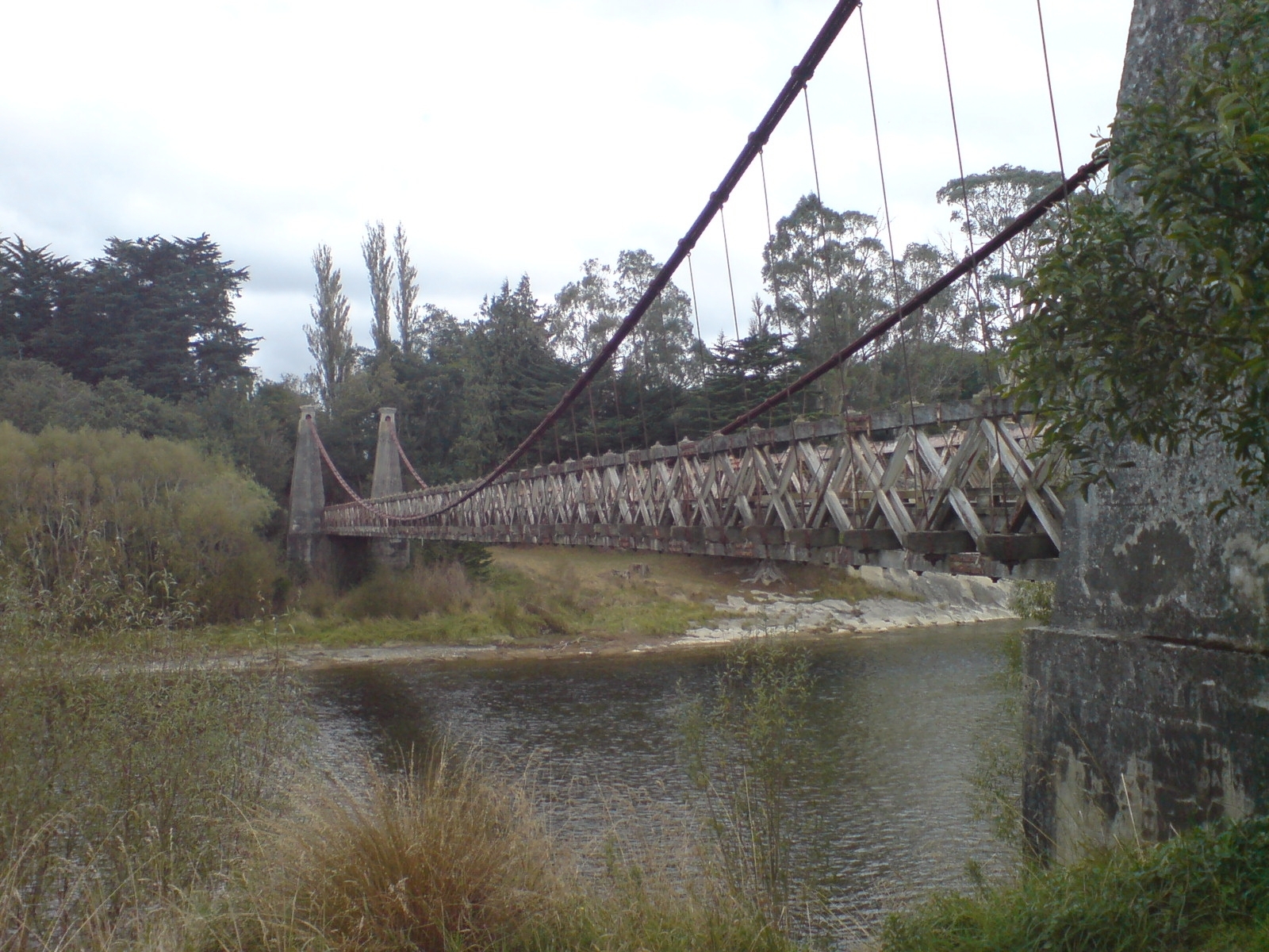
Howarth's Elegant Answer
The bridge Howarth designed was ambitious for its time and place. At 111.5 metres, it held the longest main span of any suspension bridge in New Zealand when it opened, a record it defended for years. Twenty-seven steel cables, anchored to concrete pillars clad to resemble dressed stone, support a single-lane deck of seasoned totara heartwood, a timber chosen for its extraordinary resistance to rot. Totara was the Maori's preferred wood for canoes and carvings precisely because it endures moisture without breaking down, and Howarth knew what he was asking of his materials. The engineering reflected both practical necessity and aesthetic care. He understood that a bridge in such a remote location would need to last without constant maintenance, and the totara decking he specified has proven him right, surviving more than a century of Southland's relentless damp. Visitors sometimes compare its design to a smaller cousin of Bristol's Clifton Suspension Bridge, and while the scale is vastly different, the family resemblance in the cable geometry and stone-clad towers is real.
The River It Tamed
The Waiau River that runs beneath the bridge drains Lake Te Anau and Lake Manapouri before reaching the sea at Te Waewae Bay. In the nineteenth century, its force was legendary among settlers, a huge volume of rain-fed water surging through the gorge at Clifden with enough power to capsize anything that crossed it carelessly. The punt service was essential but never safe, and the stories of livestock lost to the current were part of local lore. The bridge changed the geography of settlement in western Southland, connecting farms and communities that had been effectively isolated on the far bank. For decades it was the only way across, carrying everything from wool bales to cattle to the mail. Single-lane and open to the weather, it was not a comfortable crossing, but it was a reliable one. The bridge became so embedded in local life that when a new two-lane concrete bridge opened downstream in 1978, the old suspension bridge was not demolished. Instead, Heritage New Zealand took ownership, recognizing that the structure was too significant to lose.
Survival and Restoration
Heritage status did not guarantee an easy retirement. In 2009, an earthquake prompted a structural inspection that revealed safety concerns serious enough to close the bridge to pedestrians in April 2010. For three years the bridge stood empty, its totara deck off-limits, its cables quietly oxidizing in the damp Southland air. The New Zealand Historic Places Trust, which cares for the structure, commissioned detailed engineering reports and began conservation work that was careful and painstaking, respecting the original materials and methods wherever possible. When the bridge reopened in November 2013, the deck was solid underfoot again, the cables re-tensioned, the pillars patched. Today it stands as a Category I Historic Place, the highest level of protection Heritage New Zealand can offer. The modern concrete bridge downstream handles the traffic now, two lanes of efficient engineering that nobody photographs. Walking across the old bridge, with the Waiau churning through its gorge below and native bush pressing close on both banks, you get a physical sense of what nineteenth-century engineering could achieve with steel, concrete, and a very good piece of totara.
From the Air
Located at 46.03°S, 167.72°E over the Waiau River near the small settlement of Clifden in western Southland. The bridge is a recognizable visual landmark from low altitude, spanning the river gorge with its distinctive cable-and-pylon profile. The modern concrete bridge is visible just downstream. Nearest airport: Invercargill Airport (NZIN) approximately 90 km to the southeast. Te Anau Airport (Manapouri, NZMO) is approximately 65 km to the north. Best viewed at lower altitudes (2,000-4,000 feet) in clear conditions. The surrounding terrain is rolling pastoral land with pockets of native bush along the river corridor.