Colca Canyon
The Andean condor rides the thermals without a single wingbeat, its three-meter wingspan tracing slow circles against the canyon walls. At Cruz del Condor, the viewpoint where tourists gather each morning, the canyon floor lies nearly 4,000 feet below the rim. But the full measure of the Colca is harder to grasp: at 4,160 meters (13,640 feet) from rim to river, it is one of the deepest canyons on Earth, more than twice the depth of the Grand Canyon. The condors seem to know the scale of it. They hang in the updrafts as if the canyon were built for them.
Six Thousand Years of Terraces
Hunters and gatherers first arrived in the Colca valley roughly 6,000 years ago. Cave art at Mollepunku, near the town of Callalli, is thought to depict the domestication of the alpaca — one of the region's defining animals and economic pillars. About a thousand years ago, two cultures established themselves in the valley almost simultaneously: the Cabanas, Quechua-speaking descendants of the Wari civilization, and the Collaguas, Aymara-speakers from the Puno and Lake Titicaca region. Together, they built the vast agricultural terraces that still step down the canyon walls, engineered irrigation systems to water their crops, and constructed the qolqas — stone granaries tucked into cliff faces where the cool, dry air preserved grain and seed. In the late 14th century, the Inca absorbed the valley through intermarriage rather than conquest, perfecting the canal systems the Cabanas and Collaguas had begun.
Between Desert and Tundra
The journey from Arequipa to the canyon crosses ecological zones that shift with altitude. From the arid lowlands around Peru's second city, the road climbs through altiplano grasslands to a high point of 4,800 meters (15,800 feet) at the Mirador de los Volcanes, where volcanoes exceeding 6,000 meters line the horizon. Herds of vicuñas — wild relatives of llamas and alpacas — graze the sparse grass at these elevations. The descent into the canyon reverses the journey, dropping through zones where farmers grow quinoa, barley, and potatoes at the middle elevations, and avocados, peaches, and lucuma in the warmer depths below. The climate shifts with the calendar as well: sunny and freezing in the Andean winter, reliably dry from May through November, then green and rain-washed from December through April. The valley is at its most beautiful in April and May, when the harvested fields are green and the peaks carry fresh snow.
The Eternity Bird
The Andean condor is the canyon's most famous resident and the reason most visitors make the journey. With a wingspan of 2.7 to 3.1 meters and a lifespan of up to 70 years, the condor is commonly called the "Eternity Bird" — a symbol of endurance in Andean culture. At Cruz del Condor, the birds ride morning thermals that rise along the canyon walls, often passing within meters of the viewing platform. The canyon also hosts the giant hummingbird, the largest member of its family, along with Andean geese, Chilean flamingos during the warmer months from September through March, mountain caracaras, and eagles. On the ground, vizcachas — rabbit-sized relatives of the chinchilla — sun themselves on rocks, while deer, foxes, and the occasional zorrino move through the brush.
Villages on the Edge
The towns along the canyon rim carry the imprint of Spanish colonial policy. In the 16th century, the Toledan reductions forced indigenous populations out of their scattered settlements and into centralized towns, creating the villages that still line the valley: Chivay, Yanque, Cabanaconde, and others. Churches built between the 16th and 19th centuries anchor each town's central plaza. Chivay serves as the valley's hub, offering hot springs at La Calera three kilometers outside town, and a market for locally produced alpaca-fiber goods — hand-knitted sweaters and elaborately embroidered hats stitched on sewing machines by women who learned the craft from their mothers. Deeper in the canyon, Cabanaconde is the launching point for treks down to the Oasis de Sangalle on the canyon floor, where rustic lodges cluster around a green pocket of warmth at the bottom of the world.
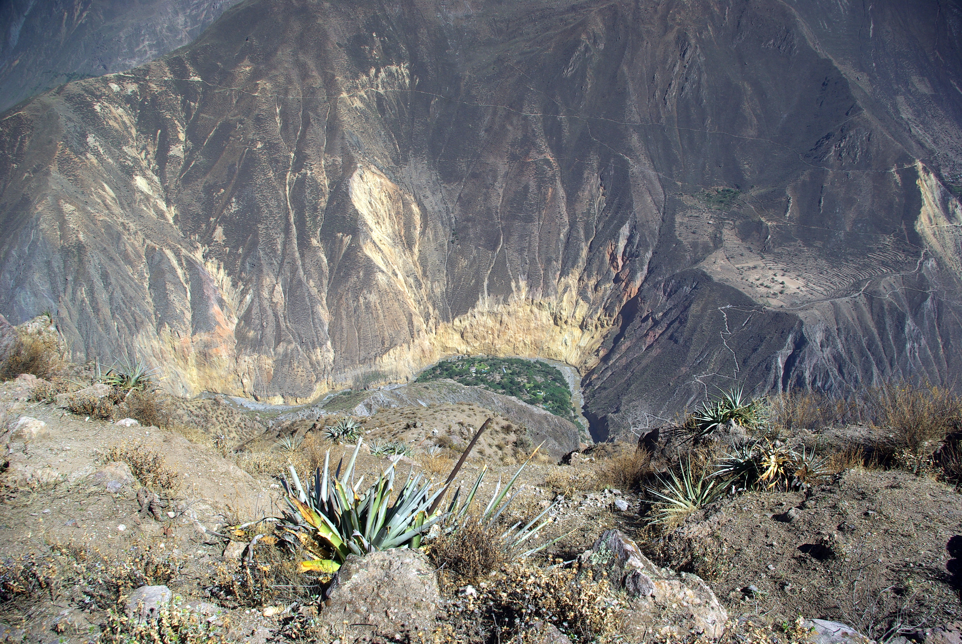
Into the Depths
The Colca became known to the outside world in 1981, when a group of Polish adventurers from the Canoandes expedition completed the first successful descent of the canyon by raft and first publicized the possibility that it might be the world's deepest. A January 1993 National Geographic article amplified the claim, and a tourism boom that began in the early 1990s has not slowed since. Today, independent trekkers descend steep, sun-baked trails from Cabanaconde to the canyon floor, where the Colca River carves through volcanic rock far below the condor thermals. The trails are strenuous — altitude and heat compound the effort — and those who cannot hike out can hire mules departing at dawn and mid-afternoon. At the bottom, the air is warm and the stars, undimmed by any city, are dense enough to read by.
From the Air
Colca Canyon is located at approximately 15.60°S, 72.06°W in southern Peru's Arequipa Region, roughly 160 km northwest of Arequipa. From cruising altitude, the canyon is visible as a dramatic gash in the Andean landscape, flanked by volcanoes exceeding 6,000 meters. The canyon depth reaches 4,160 meters, making it one of the most visually striking geological features visible from the air in South America. Rodríguez Ballón International Airport (SPQU) in Arequipa is the nearest major airfield, approximately 100 km to the southeast. Expect thin air at terrain elevations above 3,500 meters, with potential for turbulence near the canyon walls. Best visibility during the dry season (May–November).