Columbia River Estuary
The Chinook called it hayash-tsaqw -- the Great Water -- and they were not exaggerating. The Columbia River Estuary stretches from the thundering breakers at the Pacific bar all the way inland to Bonneville Dam, 146 miles upstream, the farthest point where ocean tides still nudge the river's flow. It is one of the largest estuaries on the West Coast, and one of the most contested. For 10,000 years humans have lived along its shores, fishing its channels, telling stories about how it was made. For the last two centuries, engineers have been trying to tame it with jetties, dikes, and dredges -- and the estuary has been quietly losing more than half its wetlands in the process.
The Coyote God's Handiwork
The Chinook people had their own explanation for the estuary's creation, and it involved a fight between a giant beaver and a coyote god. Wishpoosh, an enormous beaver who lived in Keechelus Lake high in the Cascades, terrorized every creature that came near the water. Speelyei, the coyote god, challenged him. Their battle was so violent it burst lake after lake -- flooding the Kittitas Valley, then Yakima, then a vast inland sea stretching from the Umatilla Highlands to the Cascade Range. When the Cascades themselves finally gave way under the onslaught, the accumulated water raced to the sea and carved the Columbia's channel. Speelyei killed Wishpoosh in the open ocean, and the beaver's body washed ashore south of the estuary. The Great Water has followed that path ever since. Beneath the myth lies a geological truth: tectonic forces really did shape this landscape, with the Juan de Fuca Plate grinding beneath the North American Plate, pushing up the Cascades and tilting the coastal crust skyward.
Salmon People
The Chinookans built their civilization around one fish. Every summer, salmon surged up the Columbia in numbers that staggered early European observers, and the Chinook were waiting. They practiced seining -- dragging weighted nets into the current and hauling them back to shore heavy with fish. The salmon trade made the Chinook prosperous and connected them to a vast network of Pacific Northwest peoples who gathered at the river for trade. When winter came, the tribes moved to villages along the Columbia's tributaries, hunting game and foraging until the salmon returned. In 1851, the Chinookans signed a treaty with federal negotiator Anson Dart that would have secured their right to remain on their ancestral lands at the estuary rather than relocate to a reservation east of the Cascades. The U.S. Congress never ratified the treaty. Legal battles over Chinook rights that began in 1899 have continued into the present day -- a reminder that the oldest inhabitants of the estuary are still fighting for recognition.
The Bar That Swallowed Ships
European explorers had a habit of sailing right past the Columbia's mouth and declaring there was nothing there. In 1788, British fur trader John Meares reached the estuary's entrance, found the breakers at the bar too violent for his ship, and concluded no river existed behind them. He named the northern headland Cape Disappointment and moved on. Four years later, American trader Robert Gray forced his ship Columbia Rediviva across the bar and became the first European to enter the estuary, naming the bay and the river after his vessel. The bar that defeated Meares remains one of the most dangerous navigational hazards on the Pacific coast. Where the Columbia's outflow collides with incoming ocean swells, the water erupts into standing waves, crosscurrents, and boils that have earned the area its grim nickname: the Graveyard of the Pacific.
An Estuary Diminished
More than half the Columbia River Estuary's original wetlands are gone. Over 70 percent of that loss came from diking and filling -- the methodical conversion of marshland into farmland and industrial ground that began in the nineteenth century and continued for decades. Jetty construction narrowed the river's mouth, dredging deepened its shipping channels, and the cumulative effect was a drastic reduction in tidal mixing and shoreline habitat. By one estimate, the estuary in its undisturbed state could have supported 138 times the number of herbivores it currently does. Two organizations have spent decades pushing back against that decline. The Lower Columbia Estuary Partnership and the Columbia River Estuary Study Taskforce have reconnected marshes to tidal flows, removed invasive plants, rebuilt beaver habitat, and restored swamps that had been cut off from the river entirely. The work is slow, measured in acres reclaimed rather than square miles, but it is returning pieces of the estuary to something closer to what the Chinook would have recognized.
A Living Crossroads
Despite everything humans have done to reshape it, the Columbia River Estuary remains extraordinarily alive. More than 70 species of fish use the estuary at some point in their lives, along with hundreds of species of birds and uncounted invertebrates. Salmon still run these waters, though in diminished numbers, navigating channels their ancestors followed for millennia. The estuary sits on an active continental margin, with the Juan de Fuca Plate subducting beneath it -- the same geological engine that produced Mount St. Helens. Pleistocene and Holocene sediments continue to fill the valley, slowly reshaping the estuary's contours. It is a landscape still being made, caught between the forces building mountains to the east and the ocean grinding them down to the west. Hiking trails now trace the shoreline, and boat tours carry visitors through the channels, but the estuary's real audience has always been the herons standing motionless in the shallows, waiting for the tide to deliver what it has delivered for ten thousand years.
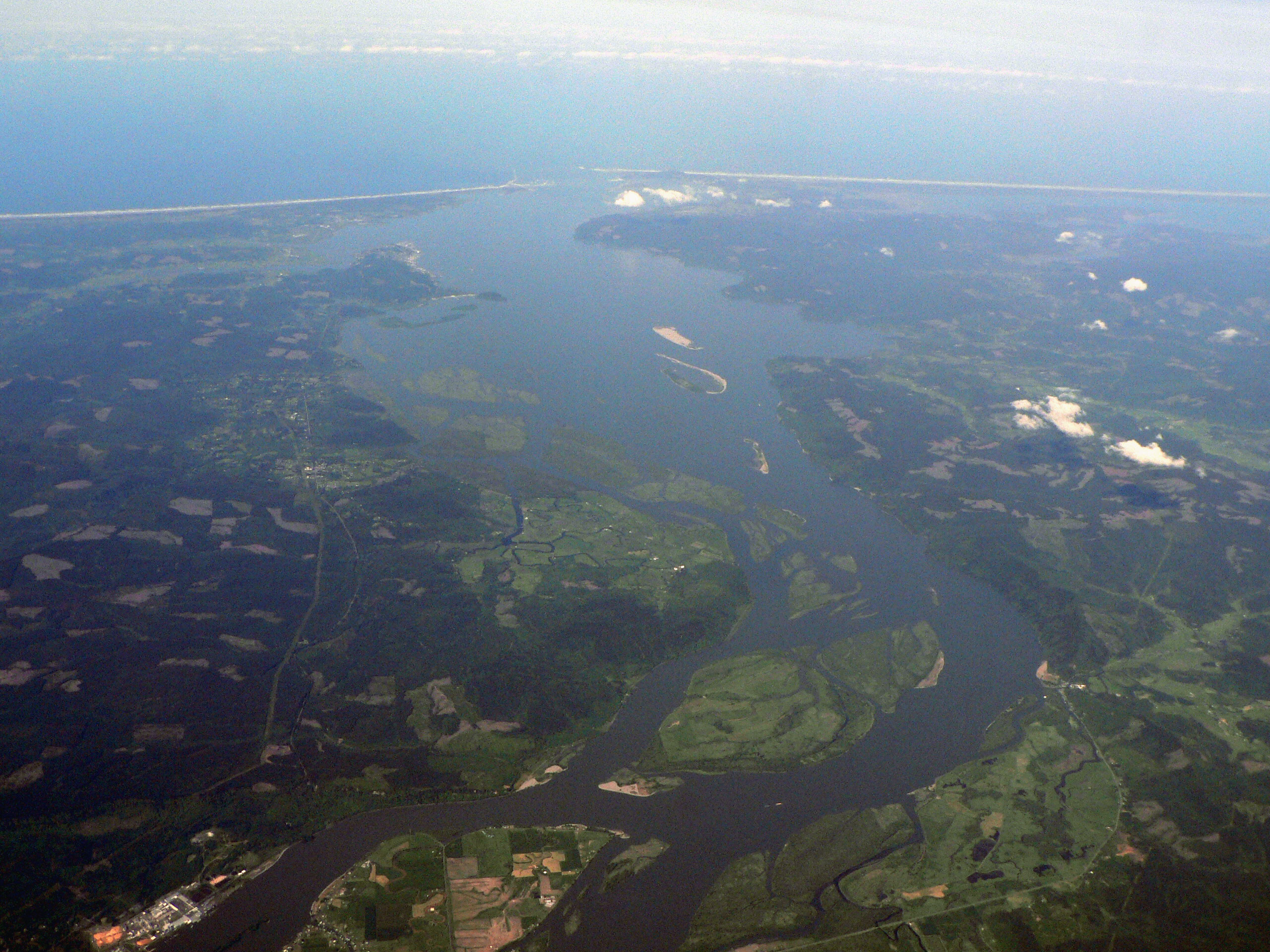
From the Air
The Columbia River Estuary is located at 46.24N, 124.06W, straddling the Oregon-Washington border at the Pacific coast. From altitude, the estuary is unmistakable: a broad, braided waterway that widens dramatically as the Columbia meets the ocean, with visible sand bars, jetties, and the white water of the Columbia Bar. The estuary extends inland to Bonneville Dam. Key visual references include Cape Disappointment headland to the north, Point Adams to the south, and the Long Beach Peninsula stretching northward. Nearest airports: Astoria Regional Airport (KAST) approximately 5nm south across the river in Oregon, Southwest Washington Regional (KELSO) approximately 50nm east. Best viewed at 2,000-5,000 feet for a sense of the estuary's full scale. Expect marine fog and overcast conditions, especially fall through spring.