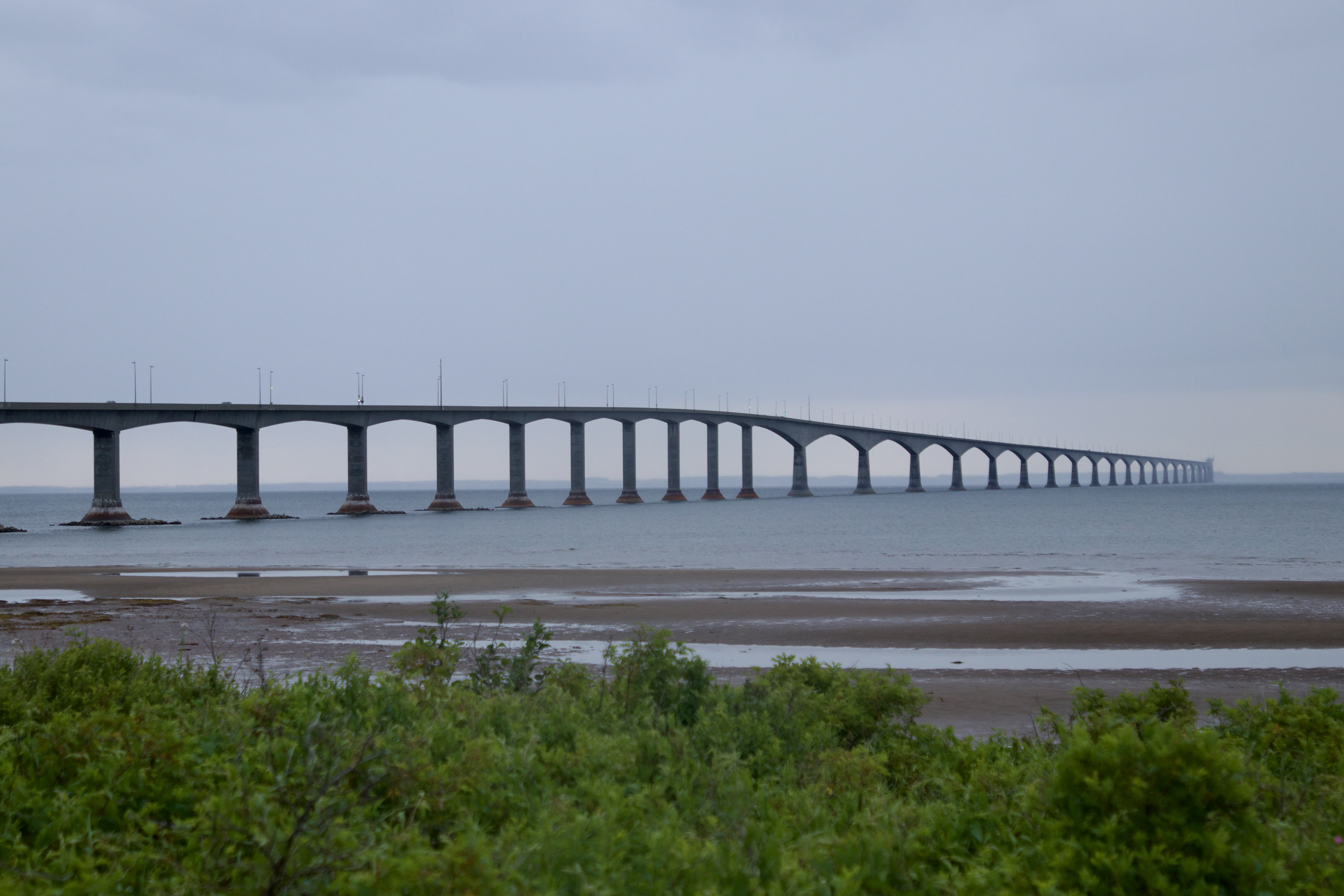
Confederation Bridge
Before the bridge, there were the iceboats. Through much of the nineteenth century, when winter locked the Northumberland Strait in crushing pack ice and steamships could not break through, passengers and mail crossed the 13-kilometer Abegweit Passage in open boats hauled by men over frozen ridges and paddled through leads of open water. It was miserable, dangerous work. Prince Edward Island's relationship with the mainland has always been defined by that strait, by the question of how to cross it and what happens when you cannot. The Confederation Bridge, opened in 1997, answered that question with 12.9 kilometers of curved concrete spanning one of the most hostile marine environments in eastern Canada.
A Century of Trying
The idea of a fixed link across the strait is older than most people realize. George Howlan called for a railway tunnel beneath Abegweit Passage in the 1870s, when the Prince Edward Island Railway was still being laid. He carried the idea all the way to the British Parliament in 1891, but it died with him in 1901. The concept resurfaced in the 1950s and 1960s, each revival conveniently timed to federal election campaigns. A rockfill causeway was proposed in 1957, just two years after the Canso Causeway opened. Tidal experts from the Canadian Hydrographic Service eventually killed that idea, calculating that currents through any gap in a causeway would exceed 18 knots, powerful enough to sweep away boulders the size of houses. In 1965, construction actually began on approach roads and railway lines at Borden and Jourimain Island for a tunnel-causeway-bridge hybrid, but the project was abandoned in 1969.
The Island Decides
When the fixed link question returned in the 1980s, it split Prince Edward Island in two. The federal government, weary of subsidizing Marine Atlantic's money-losing ferry service, a constitutional obligation dating from PEI's entry into Confederation, offered to redirect those subsidies toward building a permanent crossing. On January 18, 1988, Islanders voted in a plebiscite. The anti-link group Friends of the Island warned of ecological damage, cultural erosion, and exploitation by mainland businesses. The pro-link group Islanders for a Better Tomorrow argued that reliable transportation would transform the economy. The result was 59.4 percent in favor. Even then, years of legal challenges and environmental assessments followed before construction was formally announced on December 2, 1992.
Building Over Ice-Choked Waters
Construction began in the fall of 1993 and employed over 5,000 workers. Every major component was pre-cast on land at staging yards in Amherst Head and Bayfield, New Brunswick, then transported and placed using the HLV Svanen, a Dutch-built heavy-lift catamaran that was, for a time, the tallest man-made structure in the province. The bridge was designed to last more than 100 years. Conical ice shields encircle each pillar at the waterline, engineered to deflect ice floes rather than absorb their force. The crawler transports used to move massive pre-cast segments along Teflon-coated concrete rails earned the nickname "lobsters" from workers. At a cost of C$1.3 billion, the bridge structure was completed on November 19, 1996, when the last concrete girder was set in place at midnight. Civil engineers Mark Mallett and David Potts became the first to cross, partly on foot and partly by truck, about an hour later.
Opening Day and Its Aftermath
The official opening on May 31, 1997, was a national event. CBC broadcast the ceremony live, the schooner Bluenose II made a sailpast, the Canadian Coast Guard sent ships, and the Snowbirds performed a flyover. An estimated 75,000 people walked or ran across the bridge in the hours before it opened to traffic. That evening, the beloved ferries made their final crossings. Tourism to Prince Edward Island surged from 740,000 visitors in 1996 to 1.2 million in 1997, though it settled back to about 900,000 annually in subsequent years. The bridge's economic impact was immediate but uneven. PEI's GDP rose more than 5 percent during construction, but Cape Tormentine on the New Brunswick side, once a bustling ferry terminal, faded into a shadow of its former self.
What's in a Name
The bridge was almost called something else. A naming committee chaired by former Premier Alex Campbell selected "Abegweit Crossing," honoring both the Mi'kmaq traditional name for the island and the strait passage the bridge spans. The federal government overruled them, choosing "Confederation Bridge" instead, a decision that irked many Islanders who felt the word was already everywhere: on a ferry, an arts centre, a shopping mall, a trail system, and the province's tourism slogan. In April 2022, the PEI legislature voted unanimously to rename it "Epekwitk Crossing," using the Mi'kmaq name for Prince Edward Island, though the change requires federal approval. The bridge itself, whatever its name, remains a striking sight from any altitude: a gentle S-curve of concrete stretching across grey-blue water, connecting an island that spent more than a century trying to close the gap.
From the Air
Located at 46.22N, 63.75W, the Confederation Bridge is one of the most distinctive visual landmarks in Atlantic Canada from the air. The 12.9 km curved structure is clearly visible spanning the Northumberland Strait between Borden-Carleton, PEI and Cape Jourimain, NB. Best viewed at 3,000-5,000 feet. Nearest airports include Charlottetown (CYYG) approximately 55 km northeast and Moncton (CYQM) approximately 80 km northwest.