Cordillera de Merida
Every mountain range has to end somewhere, and the Andes -- the longest continental chain on Earth -- choose to make their exit through Venezuela with a flourish rather than a whimper. The Cordillera de Merida stretches 400 kilometers from the Colombian border in the southwest to the Venezuelan coastal ranges in the northeast, spanning 40,000 square kilometers across eight states. It is the most important branch of the Venezuelan Andes, and it contains the country's highest point: Pico Bolivar, at 4,978 meters. Two subsidiary ranges flank the city of Merida like enormous walls -- the Sierra Nevada de Merida to the south and the Sierra de la Culata to the north -- and between them, in a narrow valley at 1,600 meters, one of South America's most scenically situated cities goes about its daily life.
The Divide Between Two Worlds
The Cordillera de Merida is a continental watershed in miniature. Streams on the southeastern slopes drain into tributaries of the Orinoco River, one of the great waterways of South America, flowing east toward the Atlantic. On the northwestern side, the water runs down into Lake Maracaibo, the continent's largest lake and one of the oldest on Earth. At the southwestern end of the range lies San Cristobal, a border city facing Colombia. At the northeastern tip sits Barquisimeto, where the mountains dissolve into the lowlands and the headwaters of the River Cojedes begin their long journey to the Orinoco. Between these endpoints, the Cordillera passes through the states of Tachira, Merida, and Trujillo entirely, and touches Lara, Barinas, Portuguesa, Apure, and Zulia. It is less a single ridge than a complex of parallel ranges, valleys, and basins, each with its own microclimate and ecology.
Where the Trees Surrender
Below 3,100 meters, the Cordillera is cloaked in Venezuelan Andes montane forests -- dense, dripping woodlands where epiphytes cling to every branch and the canopy filters the light into a permanent green twilight. Above that line, the trees give way to paramo, the tropical alpine grassland found only in the northern Andes. The Cordillera de Merida paramo is an isolated enclave of this ecosystem, cut off from the larger paramo regions of Colombia and Ecuador by lower-elevation gaps. Its signature plant is the frailejone, a rosette-leaved species that grows slowly, stores water in its woolly leaves, and can live for hundreds of years. The paramo landscape feels otherworldly -- silver-green plants against dark volcanic soil, with clouds racing overhead at speeds that make the stillness of the plants seem deliberate. Over a dozen national parks protect portions of the Cordillera, including Sierra Nevada, Sierra La Culata, El Tama, and Guaramacal.
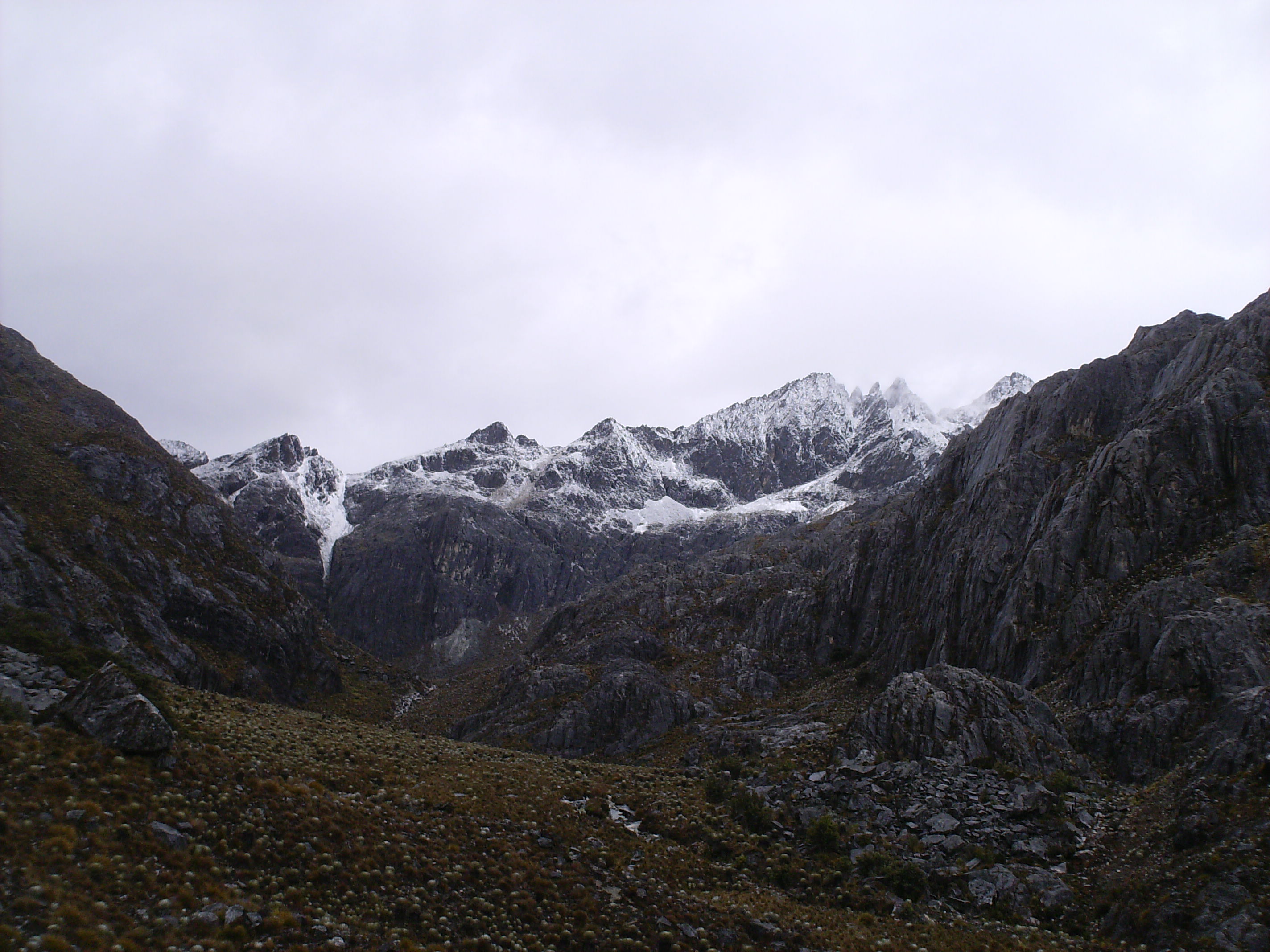
The Last Ice in Venezuela
The Cordillera de Merida once held five glaciers. By 2024, it held none. The Humboldt Glacier, clinging to the flanks of Pico Humboldt at around 4,900 meters, was the last tropical glacier in Venezuela. For years it was monitored as a bellwether of climate change at equatorial altitudes, shrinking steadily from a robust ice cap to a thin remnant. In May 2024, scientists officially reclassified it as an ice field, too small and thin to qualify as a glacier. Venezuela became the first modern nation to lose all its glaciers. Snow still covers the highest peaks seasonally -- typically above 4,200 meters, and occasionally as low as 3,800 meters during July and August -- but the permanent ice that once defined the Sierra Nevada's upper reaches is gone. The name "Sierra Nevada," which means "snowy mountain range," is becoming a historical artifact rather than a description.
Living on the Roof
The city of Merida, the Cordillera's namesake and largest settlement, occupies a terrace between the two great sierras at an elevation where the climate stays mild year-round -- warm enough for shirtsleeves by day, cool enough for a jacket by evening. The city is home to the University of the Andes, one of Venezuela's oldest and most respected institutions, and its student population gives Merida an energy that belies its mountain isolation. From the city, the Mukumbari cable car -- the highest in the world -- ascends to Pico Espejo at 4,765 meters, offering a 12.5-kilometer ride through every ecological zone the Cordillera contains. For those who prefer to walk, trails thread through cloud forest and paramo to glacial lakes, high-altitude campsites, and views that stretch from the Llanos to Lake Maracaibo. The Cordillera de Merida is where the Andes end, but there is nothing diminished about the ending.
From the Air
The Cordillera de Merida extends approximately 400 km from southwest (Colombian border) to northeast (Venezuelan coastal ranges), centered around 8.667N, 71.0W. The range includes Pico Bolivar at 4,978 meters (16,332 feet), Venezuela's highest point. Terrain rises sharply from the Maracaibo lowlands on the northwest to peaks exceeding 4,900 meters. Nearest major airport: Alberto Carnevalli Airport (SVMD/MRD) in Merida. Also: Juan Pablo Perez Alfonso Airport (SVSA) in El Vigia to the southwest. Exercise extreme caution: this is high mountainous terrain with peaks above FL160, frequent cloud formation, and rapidly changing weather conditions. The Tachira depression at the southwestern end provides a lower-elevation crossing between Venezuela and Colombia.