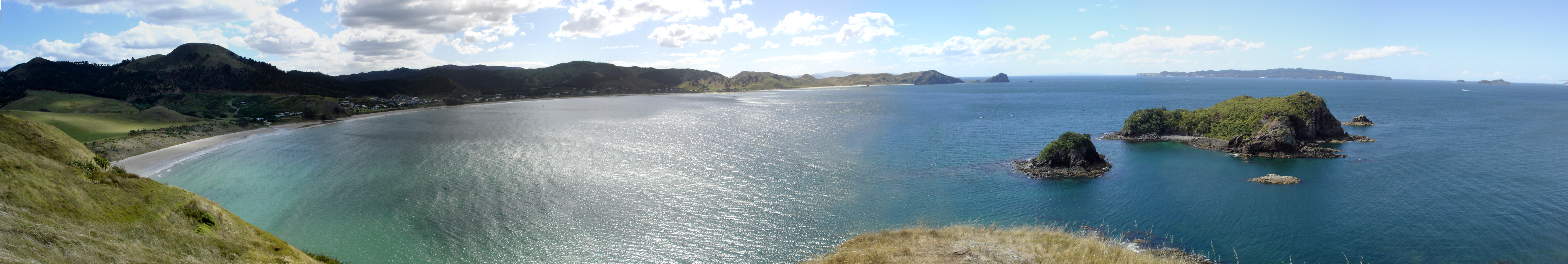
Coromandel Peninsula
The Maori name tells you what the peninsula is: Te Tara-o-te-Ika-a-Maui, "the barb of Maui's fish." In the founding legend, the demigod Maui hauled the North Island from the ocean like a great stingray, and the Coromandel Peninsula is its spine, the barb that refuses to lie flat. The geography earns the metaphor. Extending 85 kilometres north from the Bay of Plenty, 40 kilometres wide at its broadest, the peninsula is steep, hilly, and largely cloaked in native bush, with a volcanic spine that rises to nearly 900 metres at the Moehau Range. Auckland sits just 55 kilometres across the Hauraki Gulf, close enough to see the peninsula's ridgeline on a clear day, yet the interior feels like another century entirely.
Named for a Ship, Shaped by Fire
The English name comes from HMS Coromandel, a Royal Navy vessel originally called HMS Malabar, which stopped at Coromandel Harbour in 1820 to purchase kauri spars. The ship itself was named for the Coromandel Coast of India, giving the peninsula a name borrowed twice over. Beneath the kauri forest and the English nomenclature lies a far older story written in rock. The peninsula is the eroded remnant of the Coromandel Volcanic Zone, which was highly active during the Miocene and Pliocene periods. Volcanic activity has since shifted southeast to the Taupo Volcanic Zone, but the earth's heat still seeps through. Geothermal springs surface at Hot Water Beach on the east coast, where visitors dig holes in the sand and soak in water heated by the rocks below. Near Te Aroha, more hot springs testify that the peninsula's volcanic engine has not fully cooled.
Stone Tools and Gold Reefs
Long before Europeans arrived, the Tahanga Quarries at Opito Bay supplied basalt, called kara or pakawera, for Maori stone tools. Adze production was especially important during the Archaic period between 1300 and 1500. The peninsula's mineral wealth drew a different kind of extraction in the nineteenth century, when gold was discovered in quartz reefs that demanded underground mining and stamping batteries to crush the ore. At its peak, the mining town of Thames rivalled Auckland in population. Kauri forestry ran alongside the mining industry, feeding a colonial appetite for timber that nearly stripped the peninsula bare. Most mining ceased around the 1980s, and the kauri that remain are now protected, their massive trunks standing in forest parks that cover much of the interior.
Hippies, Holidaymakers, and the Coastal Strip
Almost everyone on the Coromandel lives on the narrow coastal strips. Only five towns exceed a population of one thousand: Coromandel, Whitianga, Thames, Tairua, and Whangamata. The interior remains virtually uninhabited, its steep terrain and dense bush discouraging settlement as effectively today as it did two centuries ago. In the 1970s, thousands of people from New Zealand's cities, many of them part of the back-to-the-land counterculture movement, relocated to the peninsula in search of a simpler, more environmentally conscious life. That spirit persists in the Coromandel's character, though it now coexists with a different kind of arrival: affluent Aucklanders buying coastal properties. During the summer holidays around Christmas and New Year, the population of towns like Whangamata, Whitianga, and Pauanui swells dramatically as families from across the North Island fill holiday homes and baches.
Cathedral Cove and the Returning Whales
The coastline is the peninsula's main draw. Cathedral Cove, accessible only by boat or on foot, takes its name from a natural arch cut through limestone cliffs. Whitianga, on Mercury Bay, is renowned for yachting; the peninsula's waters draw scuba divers to reefs and offshore islands including the Mercury Islands, the Aldermen Islands, and Slipper Island. In recent years, dolphins and coastal whales have been appearing in increasing numbers as populations recover, with southern right whales, Bryde's whales, and humpback whales sighted along the shores. Great Barrier Island, lying beyond the peninsula's northern tip and separated from Cape Colville by the Colville Channel, can be thought of as a geological extension of the same ranges.
Five Minutes or Forty-Five
State Highways 25 and 25A loop around the peninsula, but not all roads are sealed. The 309 Road connecting Coromandel Town to Whitianga is gravel, and some car rental companies specifically forbid driving on it. A pedestrian ferry crosses the harbour from Ferry Landing to Whitianga in five minutes. The same journey by road takes forty-five. That contrast captures the Coromandel's essential quality: it is close to everywhere and far from everything. From Auckland's waterfront, the peninsula's ridgeline appears as a blue shadow across the Hauraki Gulf. Getting there is easy. Getting into its interior, where the bush thickens and the roads narrow, is another matter entirely.
From the Air
Located at 36.83°S, 175.58°E. The peninsula extends 85 km north from the Bay of Plenty, clearly visible from altitude as a mountainous finger separating the Hauraki Gulf from the Pacific Ocean. The Coromandel Range spine reaches nearly 900 m at the Moehau Range. Nearby airports: Thames Aerodrome (NZTH), Whitianga (NZWT), Auckland International (NZAA) 55 km west across the Gulf, Tauranga (NZTG) to the southeast. Recommended viewing altitude: 5,000-8,000 ft for the full sweep of the peninsula, its offshore islands, and the contrast between the sheltered western coast and the Pacific-facing east.