Crazy Mountains
The Crow people called them Awaxaawippiia, the Ominous Mountains. They came here for vision quests, drawn by the range's reputation for metaphysical power and unpredictability. The English name carries its own tragedy: Crazy Woman Mountains, they were first called, after a woman who fled into these peaks and lived alone after her family was killed during westward expansion. The Crazies stand apart from Montana's other ranges in every sense, an isolated island of rock and snow rising more than 7,000 feet above the Great Plains, plainly visible from Interstate 90 yet almost unreachable due to the private lands that surround them.
Islands on the Prairie
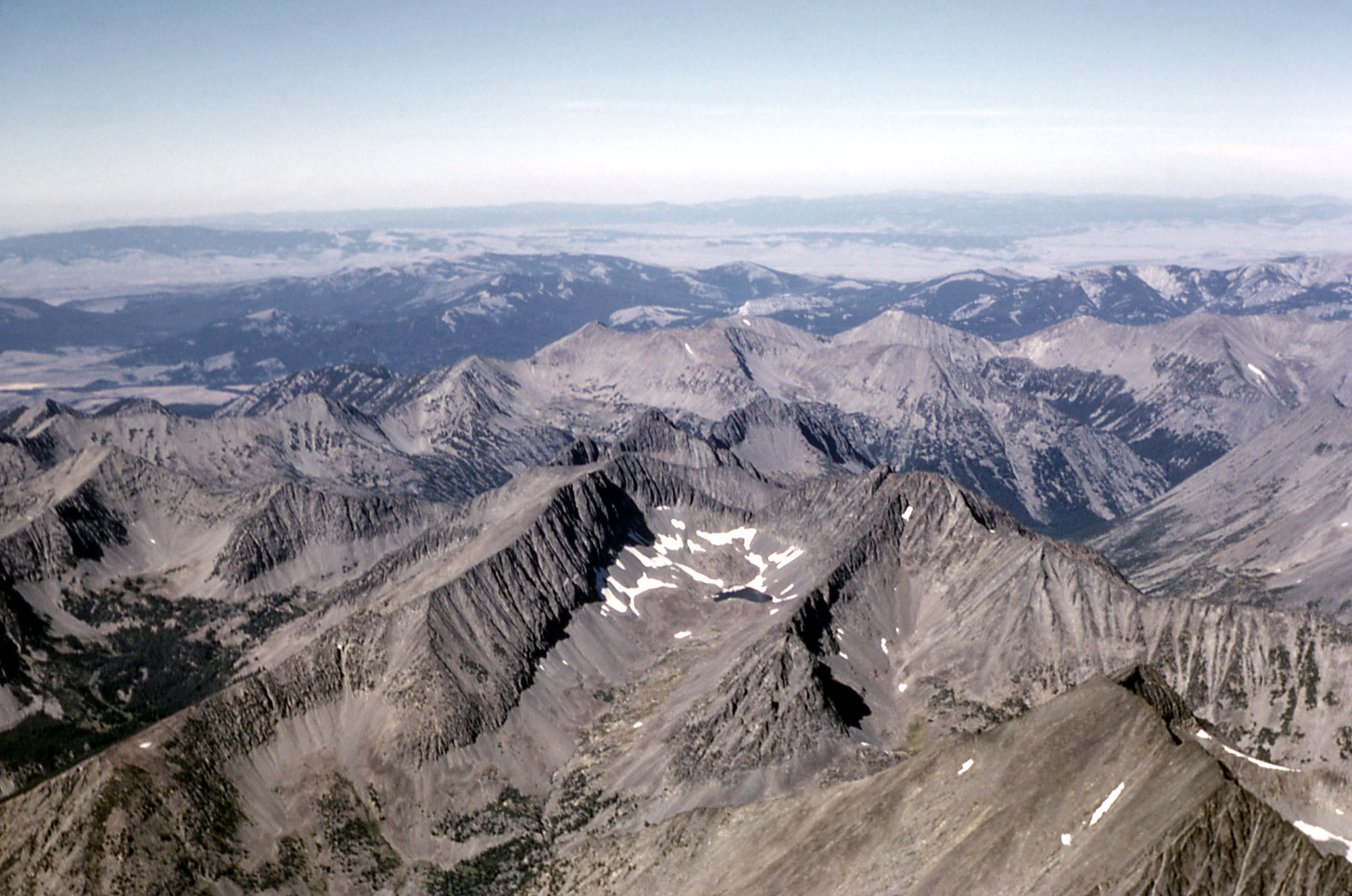
The Crazy Mountains form an isolated island range east of the Continental Divide, one of Montana's peculiar geological orphans separated from the main Rocky Mountain chain. Spanning 40 miles between the Musselshell and Yellowstone Rivers, the Crazies dominate their surroundings with Crazy Peak reaching 11,214 feet at its summit. Other isolated ranges dot Montana's eastern landscape like the Castle Mountains, Little Belt Mountains, Big Snowy Mountains, Bears Paw Mountains, and the distant Long Pines near Ekalaka, but the Crazies stand tallest and most dramatic. Due to their eastern location, these mountains receive less precipitation than ranges farther west, making them drier and less densely forested than typical Montana peaks.
Fire Beneath the Surface
The Big Timber Stock, a massive igneous intrusion, forms the bedrock of the Crazy Mountains. This geological feature dates to the Tertiary period, when molten rock pushed upward through the Earth's crust and solidified into diorite and gabbro with zones of quartz monzodiorite. Many dikes and sills cut through the formation, evidence of the volcanic activity that shaped this landscape millions of years ago. The mountains sit within the Central Montana Alkalic Province, a geological region defined by its distinctive volcanic and intrusive rocks. At least 40 alpine lakes fill the glacially carved basins of the range, with 15 significant enough to have been formally named.
Twice Denied
The Crazy Mountains nearly became a national park, not once but twice. In 1916, Congress considered legislation to protect the range, but the bill never passed. National Park Service officials returned in 1935 to evaluate the area again. Their conclusion was blunt: a national park would not be feasible because half of the land, every alternate section, is owned by the Northern Pacific Railroad or is in private hands. This checkerboard pattern of ownership, a legacy of nineteenth-century railroad land grants, continues to shape access to the Crazies today. The mountains remain almost completely surrounded by private lands, making entry difficult, especially in the southern section where the highest peaks stand.
Sacred Ground
For the Crow people, the Crazy Mountains held spiritual significance beyond ordinary geography. The Crow name Awaxaawippiia translates roughly as Ominous Mountains, acknowledging the range's reputation for unpredictability and metaphysical power. This was vision quest territory, a place where individuals came seeking spiritual revelation through isolation, fasting, and exposure to the elements. The mountains' dramatic rise from the surrounding plains, their isolation from other ranges, and their challenging weather patterns all contributed to their sacred status. The name eventually settled into English as the Crazy Mountains, preserving something of both traditions, the Crow recognition of the mountains' strange power and the settler story of the woman who found refuge in their peaks.
Wild Residents
Despite their drier climate, the Crazies support remarkable wildlife. A healthy herd of mountain goats navigates the rocky slopes, their white coats visible against dark granite faces. The elusive wolverine occasionally appears, one of North America's rarest carnivores surviving in these isolated heights. The range falls within both Gallatin National Forest and Lewis and Clark National Forest, split between two administrative regions like the checkerboard of private and public lands below. The ongoing battle over access continues to make headlines, with conservation groups and private landowners contesting trail rights and boundaries. For now, the Crazies remain what they have always been: visible from a distance, difficult to reach, and wrapped in stories of loss, power, and transformation.
From the Air
Located at 46.02°N, 110.28°W in central Montana, rising dramatically from the plains north of Interstate 90. Crazy Peak (11,214 ft) is the highest point. The range sits between the Musselshell and Yellowstone Rivers. Nearest airports include Bozeman Yellowstone International (KBZN) to the southwest and Billings Logan International (KBIL) to the east. The Crazies are an excellent visual reference when flying across Montana's agricultural plains. Watch for rapidly changing weather and strong winds, as the isolated range generates its own microclimate.