Croesus Track
They named the mining company after Croesus, the ancient king whose wealth became a byword for impossible riches. It was 1896, and prospectors had found gold-bearing quartz reefs high in the Paparoa Range above Blackball. The Croesus Gold Mining Company was formed, investors were recruited, and heavy ore-crushing machinery was hauled up a pack track through some of the densest bush on New Zealand's West Coast. Within a decade, the gold had proven insufficient, the company had dissolved, and the track fell silent. More than a century later, the trail they built is the attraction the gold never was.
The Miners' Highway
The track's origins reach back to the 1860s gold rush that brought prospectors flooding into the Paparoa foothills and established the town of Blackball. Miners first cut a rough route up Blackball Creek to reach their claims, and between 1881 and 1899 this was gradually improved into a proper pack track reaching the Paparoa tops. Gold in this part of the range was locked in quartz reefs rather than loose in creek beds, which meant extraction required industrial machinery. When the Croesus company formed in 1896, the track became a supply line. In 1901, the Garden Gully Company took over and in 1904 managed to move a large stamper battery - the heavy equipment used to crush ore - into the mountains along this narrow trail. The gold never repaid the effort, and the company was dissolved two years later.
From Ruin to Revival
After mining ceased, the West Coast bush reclaimed the track with characteristic efficiency. Decades of rain, root growth, and windfall erased much of what the miners had built. The Croesus Track might have disappeared entirely if not for Ces Clark, a Blackball resident and Forest Service ranger who led a team in the 1970s to reopen the old route. They cleared fallen trees, rebuilt sections of track, and made the trail accessible to trampers once again. A hut on the bush edge now bears Clark's name - a fitting memorial for the man who recognized that the miners' pack track, stripped of its commercial purpose, had become something more valuable: a way into country that few New Zealanders had ever seen.
Crossing the Range
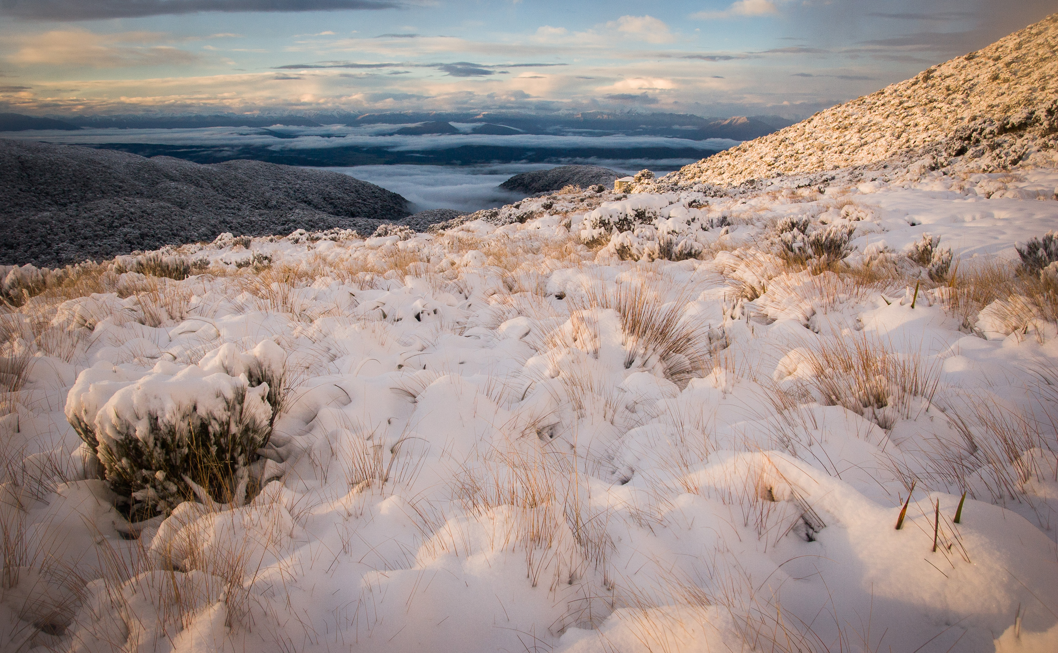
The Croesus Track runs 22.1 kilometers from Blackball in the Grey Valley to Barrytown on the Tasman Sea coast, crossing the Paparoa Range along the way. The ascent from Blackball climbs through dense podocarp forest - rimu, rata, and kamahi - before emerging above the bush line into tussock and alpine herbfields. The tops of the Paparoa Range offer views in every direction: the Grey Valley and its patchwork of farmland to the east, the Tasman Sea and its long, empty coastline to the west. The descent to Barrytown drops steeply through forest to the coastal plain. The first section from Blackball is now shared with the newer Paparoa Track, a Great Walk opened by the Department of Conservation, making this one of the few trails in New Zealand where hikers and mountain bikers share the same historic route.
Ghost Machinery in the Mist
Traces of the mining era survive along the track. Rusted remnants of the stamper battery, abandoned where the gold ran out, sit among the tree roots and moss. The concrete foundations of mine buildings are slowly being absorbed by the bush floor. On the Paparoa tops, where cloud often rolls in from the Tasman Sea and reduces visibility to a few meters, the relics appear and vanish in the mist like memories surfacing and submerging. The track itself is the most enduring artifact - a line through the landscape that has outlived the industry that created it. Miners cut it for profit. A ranger reopened it for love of the bush. Trampers now walk it for the experience of crossing a mountain range on foot, which may be the richest return the Croesus track has ever delivered.
From the Air
Located at 42.26S, 171.36E in the Grey District, South Island, New Zealand. The track crosses the Paparoa Range from Blackball (Grey Valley, east side) to Barrytown (Tasman Sea coast, west side), running south of Paparoa National Park. From the air, the Paparoa Range is visible as a forested ridge running roughly north-south between the Grey Valley and the coast. Blackball is a small settlement visible in the valley. Nearest airport is Hokitika Aerodrome (NZHK), approximately 60 km south. Best viewed at 3,000-6,000 ft for the full range crossing. Weather is frequently overcast with cloud on the tops.