Crooked River Railroad Bridge
The first train crossed on September 17, 1911. Half the rivets holding the bridge together had not yet been installed. This was not recklessness but urgency born of railroad war. Two of America's most powerful tycoons, James J. Hill and Edward Harriman, were racing their construction crews up the Deschutes River canyon toward Bend, Oregon, and the vast timber stands that lay beyond. The prize would go to whoever controlled the single point where the Crooked River could be crossed. Hill won that fight on December 1, 1909, when his Oregon Trunk Railroad acquired the Central Oregon Railroad Company, a paper railroad that owned no track but held the rights to the only bridge site where canyon walls stood close enough together to span.
The Race for the Gorge
The Deschutes River canyon offered the only practical route into central Oregon's timber country. Hill's Oregon Trunk Railway started up the west bank while Harriman's Des Chutes Railroad claimed the east. The two lines jousted for position until North Junction, where Hill's crews crossed to the east side. Both railroads knew they would have to bridge the Crooked River, a major Deschutes tributary that carved a deep gorge through the high desert. But there was only one place where a bridge was possible. When Hill secured that site through his Central Oregon Railroad acquisition, Harriman had no choice but to negotiate. The settlement gave Hill ownership of nearly the entire line from the Columbia River to Bend, while Harriman's Union Pacific retained the right to use the track, an arrangement that persists today under BNSF Railway.
Building from Both Sides
Ralph Modjeski, the engineer who would later design the San Francisco-Oakland Bay Bridge, drew the plans. The Missouri Valley Bridge and Iron Company built the structure by cantilevering it out from rock walls on both sides of the canyon. A famous photograph shows workers climbing rope ladders up the cliff face, spawning a myth that bridge builders camped at the canyon bottom and climbed to work each day. The truth was less romantic: crews lived two miles north at Opal City, a construction camp that was expected to thrive into the future. The camp vanished completely soon after the railroad was finished. The first steel arrived on May 18, 1911, lowered by derrick to the canyon floor where workers attached cables so beams could be hoisted back up as needed.
Four Months to the Golden Spike
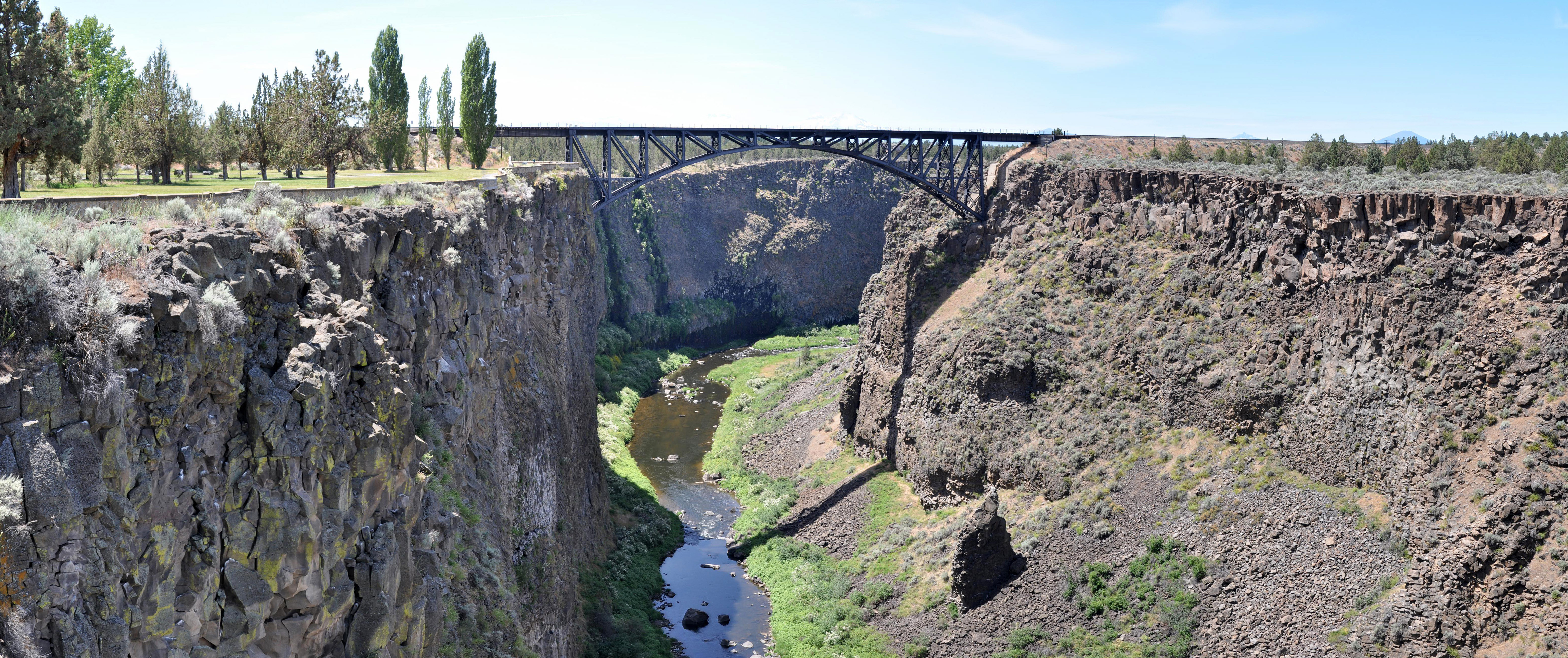
Speed mattered more than caution. Hill needed to reach Bend and drive the golden spike before winter, so trains began crossing the partially-completed bridge on September 17. Workers spent weeks afterward finishing the riveting while locomotives rumbled overhead. Eighteen days later, on October 5, 1911, Hill himself drove the ceremonial spike at Bend. The bridge had served its purpose: 320 feet above the Crooked River, its steel two-hinge arch carried the rails that finally opened central Oregon to the outside world. Great Northern extended the line south to Chemult in 1928, completing a route that still hauls freight through this high desert landscape more than a century later.
Spanning the Canyon Today
The Crooked River Railroad Bridge remains in active service under BNSF Railway, standing as the second-highest railroad bridge in the United States when it was completed. Less than a mile upriver, three other crossings now span the gorge: the Crooked River High Bridge, the Rex T. Barber Veterans Memorial Bridge carrying US-97, and the Peter Skene Ogden State Scenic Viewpoint. Photographer Olof Hedlund of Madras documented the original construction, preserving images of workers silhouetted against canyon walls as they assembled the steel arch piece by piece. Those photographs capture a moment when railroad technology and the ambitions of rival tycoons transformed an inaccessible canyon into a gateway.
From the Air
The Crooked River Railroad Bridge is located at 44.39N, 121.20W in southern Jefferson County, Oregon. The steel arch spans the Crooked River canyon approximately 320 feet above the water. Look for it less than a mile downstream from the more prominent US-97 highway bridges. Best viewed from 2,000-3,000 feet AGL for canyon depth perspective. The Peter Skene Ogden State Scenic Viewpoint provides ground-level comparison. Nearby airports: KRDM (Redmond Municipal) 20nm south, KSLE (McNary Field/Salem) 90nm west. The canyon creates significant terrain features; maintain awareness of canyon rim elevations around 3,000 feet MSL.