Crossraguel Abbey
In 1570, Gilbert Kennedy, 4th Earl of Cassillis, wanted the lands of Crossraguel Abbey. Allan Stewart, the abbey's commendator -- the layman appointed to manage its revenues after the Reformation -- held the deed. The Earl's method of persuasion was not subtle: he took Stewart to his castle at Dunure and roasted him over an open fire until he signed. The resulting feud drew in multiple families and lasted more than forty years. It is one of the most notorious episodes in Scottish ecclesiastical history, and it unfolded around an abbey that had already endured three centuries of power struggles, papal appeals, and English invasion before the Kennedys decided the quickest path to its wealth ran through a fireplace.
Black Monks on the Pilgrim Road
Crossraguel Abbey was founded in 1244 by Duncan, 1st Earl of Carrick, who enlisted monks from Paisley Abbey to build a Cluniac monastery near what is now Maybole in South Ayrshire. The Cluniac order, a branch of the Benedictines, were known as the 'Black Monks' for the colour of their habits. Their mission was to encourage pilgrimage, and Crossraguel's location was no accident -- it sat halfway between Paisley Abbey and the shrine of St Ninian at Whithorn, on the Ayrshire pilgrims' trail through the Machars of Galloway. The abbey's name comes from the ancient Cross of Riaghail -- the cross of St Regulus -- that once stood on the site.
Paisley's Swindle and the Bishop's Justice
The founding of Crossraguel involved a medieval legal dispute worthy of a courtroom drama. The Earl of Carrick gave land and funds to Paisley Abbey to build the new monastery, but Paisley's superiors built only a small chapel and kept the rest of the money. The Earl took the case to the Bishop of Glasgow, who ruled decisively in his favour: Paisley must not only build the monastery properly but also transfer monks there and hand over all its possessions in Carrick. The monks of Crossraguel were given the authority to choose their own abbot free of Paisley's interference, though the abbot of Paisley was permitted one annual visit. Paisley appealed to the pope in 1265 and lost.
Sacked, Rebuilt, and Roasted
Edward I's army sacked Crossraguel in 1307, but the destruction provided an opportunity to rebuild on a grander scale -- a project that occupied much of the rest of the Middle Ages. By the early 16th century, the abbey had diversified beyond prayer: around 1510, under the direction of the 1st Earl of Cassillis and with encouragement from James IV, the monks developed salt production by boiling seawater and manufactured charcoal for gunpowder. The Reformation of 1560 did not badly damage the physical fabric of Crossraguel, but it ended monastic life; the last monk died in 1601. It was the Kennedy family's violent seizure of the abbey lands in 1570 -- the roasting of Allan Stewart -- that became the defining story, a feud that embroiled the region until at least 1611.
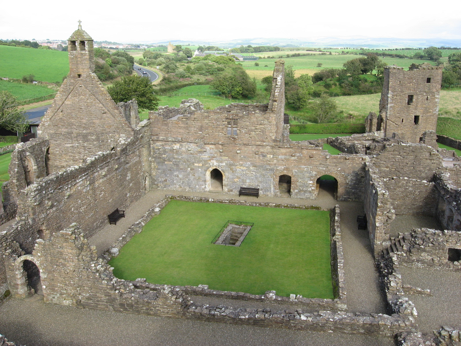
Among the Most Complete in Scotland
Despite centuries of stone removal for local construction, Crossraguel's ruins remain among the most complete of any medieval religious house in Scotland. Visitors can still see the monks' church, the cloister, the chapter house with its original stone benches and an arched abbot's seat, and a dovecote -- the pigeon tower that supplied the monks with fresh meat. The gatehouse tower is intact enough to climb, offering views across the Ayrshire countryside to the sea. Fine 15th-century architectural details survive throughout, preserved by the quality of the local stone. Historic Environment Scotland maintains the site as a scheduled monument, a quiet place where the ambitions of earls and abbots, the industry of Black Monks, and the cruelty of the Reformation era can all be read in the same weathered walls.
From the Air
Crossraguel Abbey is at 55.34N, 4.72W near Maybole in South Ayrshire, on the west coast of Scotland. The ruins sit in agricultural land roughly 2 miles southwest of Maybole. The Ayrshire coast and Firth of Clyde are visible to the west. Nearest airports: Glasgow Prestwick (EGPK, 12nm north) and Ayr/Prestwick area. The distinctive shape of Ailsa Craig in the Firth of Clyde is visible offshore. The A77 road passes nearby.