The Frank Slide Interpretive Centre
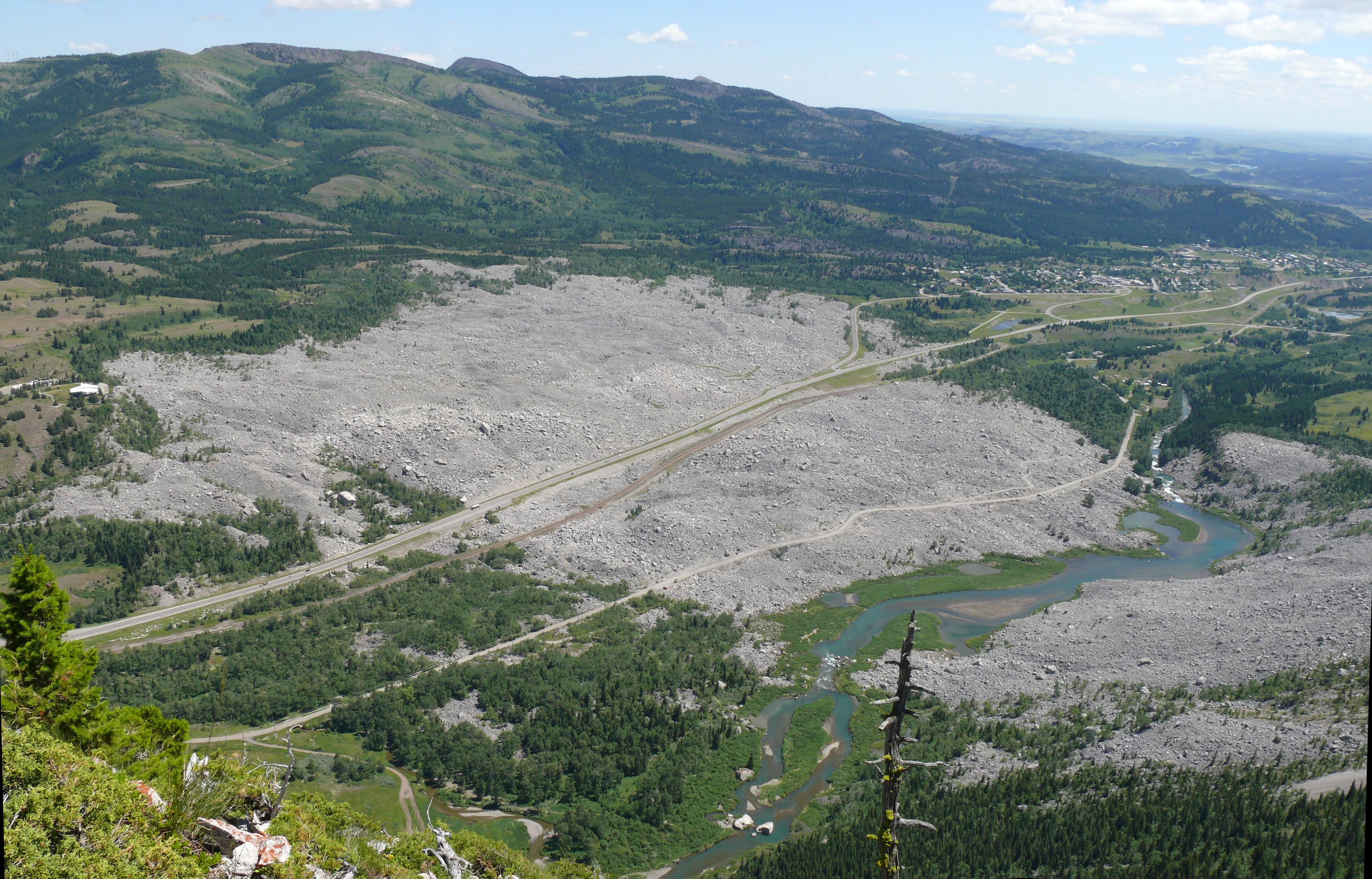
At 4:10 AM on April 29, 1903, Turtle Mountain came apart. In roughly 100 seconds, 110 million tons of limestone broke from the peak and roared down onto the sleeping town of Frank, Alberta. The slide buried the southern end of town, part of the coal mine, a railway, and everyone caught in its path. At least 70 people died - the exact number was never determined because some bodies were never found. The debris field spread nearly three kilometers across the Crowsnest Valley floor, burying the landscape under 30 meters of shattered rock. Today the Frank Slide looks exactly as it did 120 years ago: a chaos of gray boulders covering the valley floor, the scar on Turtle Mountain still raw, a memorial to the 100 seconds when gravity did what gravity eventually does.
The Mountain
Turtle Mountain had been warning people for years. The Blackfoot called it 'the mountain that moves.' Early European settlers reported rockfalls and strange sounds. Coal mining operations had honeycomb the base with tunnels since 1901 - whether this weakened the mountain or was simply coincidence remains debated. The geological reality was simpler: Turtle Mountain was a layer cake of limestone tilted at a steep angle, its base undermined by a weak coal seam, its structure fractured by ancient faults. The mountain was falling in slow motion long before anyone arrived. The slide was not an accident but an inevitability that happened to occur at 4:10 AM on a spring morning.
The 100 Seconds
The slide began near the summit - a fracture, then a cascade. Witnesses described a roar like thunder, a blast of wind that knocked buildings flat, then silence as the dust settled on a transformed landscape. The rock traveled at 100 kilometers per hour, crossing nearly three kilometers in less than two minutes. The southern part of Frank was buried. The entrance to the coal mine was blocked. A railway locomotive was thrown hundreds of meters. Some survivors emerged from buried houses; others were never found. Seventeen miners trapped inside the mine dug themselves out over fourteen hours - through solid coal, emerging from the mountain's opposite side. Morning revealed a town half-destroyed, a landscape unrecognizable.
The Aftermath
Rescue efforts were futile - the burial depth made recovery impossible for most victims. Some bodies were found at the edges; most remain under the rock. The coal mine reopened within weeks; Frank was rebuilt, though never recovering its former size. The railway was rerouted over the debris field. Engineers studied the slide, learning lessons about mountain stability that inform land-use planning today. Turtle Mountain still stands, still moves slightly, monitored by sensors that watch for the next collapse. The summit remains unstable - another slide is possible, though Frank and the current highway are outside the predicted debris zone.
The Memorial
The Frank Slide Interpretive Centre, opened in 1985, overlooks the debris field from the valley's north side. Exhibits explain the geology, the community, and the disaster through artifacts, photographs, and survivor accounts. The slide itself is the main exhibit - visible through windows, walkable on trails through the boulders. The rock is still there, exactly where it landed: gray limestone chunks the size of houses scattered across what was once a valley floor. Walking through the debris is eerie; this is a mass grave, unmarked and permanent. The mountain's scar is visible above, lighter rock exposed where 110 million tons tore away.
Visiting the Frank Slide
The Frank Slide Interpretive Centre is located on Highway 3, the Crowsnest Highway, 1.5 kilometers northeast of the town of Frank, Alberta. The centre is open year-round; admission is charged. Exhibits and a film explain the disaster; trails through the debris field allow close exploration of the slide. The debris is unstable in places - stay on marked trails. The town of Frank has historical plaques and a small museum. Blairmore and Coleman, nearby Crowsnest Pass communities, offer services. Waterton Lakes National Park is 90 kilometers south; Calgary is 250 kilometers northeast. The highway crosses the slide on an elevated route; you can stop and walk among the boulders that killed a town.
From the Air
Located at 49.58°N, 114.42°W in the Crowsnest Pass, Alberta. From altitude, the Frank Slide is immediately visible as a gray scar spreading across the valley floor - 110 million tons of debris covering three square kilometers. The slide extends from Turtle Mountain's broken north face down to the valley floor where Frank once stood. Highway 3 crosses the debris field on an elevated grade. The interpretive centre sits on the valley's north side, overlooking the slide. The Crowsnest Pass continues west toward British Columbia; the Rocky Mountains rise to the west. The scar on Turtle Mountain is visible - raw rock where the summit used to be, evidence of the 100 seconds that remade this landscape.