Culebra Cut
They called it the Snake Cut -- corte culebra in Spanish -- after the serpentine ridge it had to slice through. The Culebra Cut is an artificial valley carved through the Continental Divide of Panama, and its construction nearly broke two nations before it was finished. The French tried first and failed. The Americans succeeded, but only after moving more earth than any construction project in history had attempted, battling landslides that engineers compared to glaciers made of mud.
The French Gamble
Ferdinand de Lesseps, fresh from his triumph building the Suez Canal, arrived in Panama with a bold plan: a sea-level canal straight through the mountains, no locks required. Digging at Culebra began on January 22, 1881, and the problems started almost immediately. Tropical disease devastated the workforce. The sheer volume of rock and earth exceeded every estimate. Financial difficulties mounted as investors grew uneasy. By the time the French effort collapsed and was bought out by the United States in 1904, de Lesseps's crews had excavated some 14 million cubic meters of material and lowered the summit by just five meters -- from 64 to 59 meters above sea level -- over a relatively narrow width. It was an enormous amount of work that barely scratched the surface of what remained.
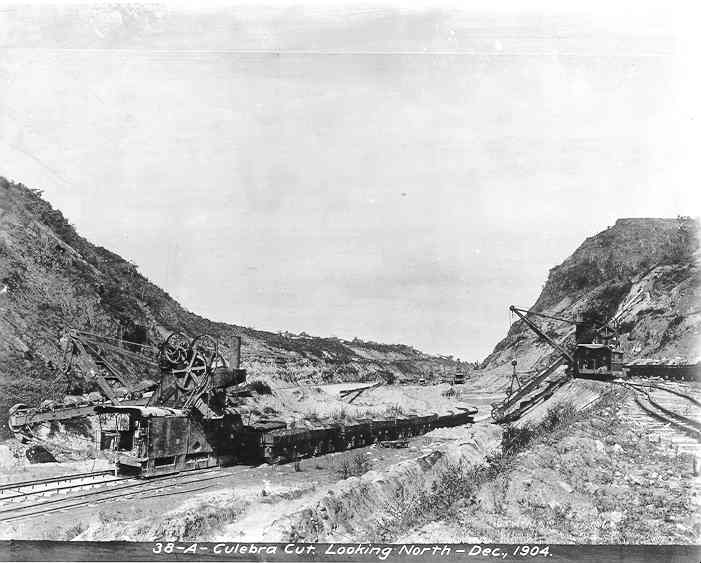
Six Thousand Men in the Ditch
The Americans abandoned the sea-level dream. Under John F. Stevens and later George Washington Goethals, they redesigned the canal as an elevated lock system, which meant the cut did not need to reach sea level -- but it still needed to be vastly wider. The new plan called for a bottom width of 91 meters and a valley up to 540 meters wide at the top. Major David du Bose Gaillard of the U.S. Army Corps of Engineers took charge of the excavation. Six thousand men worked the cut daily, drilling blast holes, placing dynamite, operating steam shovels, and running the dirt trains that hauled spoil to dump sites 12 miles away. The operation consumed 400,000 pounds of dynamite every month. More than 600 blast holes were detonated each day, and at peak activity, a spoil train entered or left the cut nearly every minute -- 160 trainloads hauled away in a typical workday.
Tropical Glaciers
The landslides were the great terror of Culebra. Engineers had calculated that the rock walls would hold stable at a slope of 1 in 1.5 up to a height of 73.5 meters. In practice, the rock began collapsing at just 19.5 meters. Water seeping through iron-bearing strata caused oxidation that weakened the underlying shale, and whole hillsides simply gave way. The first major slide struck at Cucaracha on October 4, 1907, when roughly 500,000 cubic yards of clay slumped into the excavation. Gaillard described these slides as tropical glaciers -- made of mud instead of ice. The clay was too soft for steam shovels to handle, so crews sluiced it out with high-pressure water jets. Of the 76 million cubic meters the Americans ultimately excavated, some 23 million cubic meters were material that the landslides had dragged into the cut uninvited. Each slide prompted voices declaring the canal impossible. Each time, the work continued.
Breakthrough and a Quiet Death
Steam shovels broke through the Culebra Cut on May 20, 1913. The summit had been lowered from 194 feet to canal level, and the narrow French trench had become a broad, engineered valley with water standing 85 feet above sea level. Gaillard was promoted to colonel that same year. One month later, on December 5, 1913, he died of a brain tumor in Baltimore. He never saw a ship pass through the cut he had spent years carving from the mountain. In his honor, the passage was renamed Gaillard Cut on April 27, 1915. The name stuck for 85 years, until Panama regained control of the canal in 2000 and restored the original Spanish name: Culebra.
The Scar That Connects Oceans
Today the Culebra Cut stretches 7.8 miles from the Pedro Miguel locks on the Pacific side to the Chagres River arm of Gatun Lake. Ships glide through it in eerie calm, their hulls towering above the waterline in the narrow channel while jungle presses in from both sides. Landslides continued to plague the cut for decades after the canal opened, causing intermittent closures and ongoing widening projects. The geology that nearly defeated two empires remains restless. From the air, the cut reads as a ruler-straight gash through green mountains -- the most visible evidence of what it cost to join the Atlantic and Pacific. It is 7.8 miles of proof that human stubbornness, when supplied with enough dynamite, can overcome even the Continental Divide.
From the Air
The Culebra Cut is centered near 9.077N, 79.675W, running roughly north-south through the Continental Divide. From altitude, it appears as a straight, water-filled channel cutting through green ridges between Pedro Miguel Locks to the south and Gatun Lake to the north. The cut is clearly visible at 3,000-5,000 feet. Nearby airports include Marcos A. Gelabert International (MPMG) approximately 15 km southeast and Tocumen International (MPTO) about 45 km east. Ships transiting the cut are often visible from above.