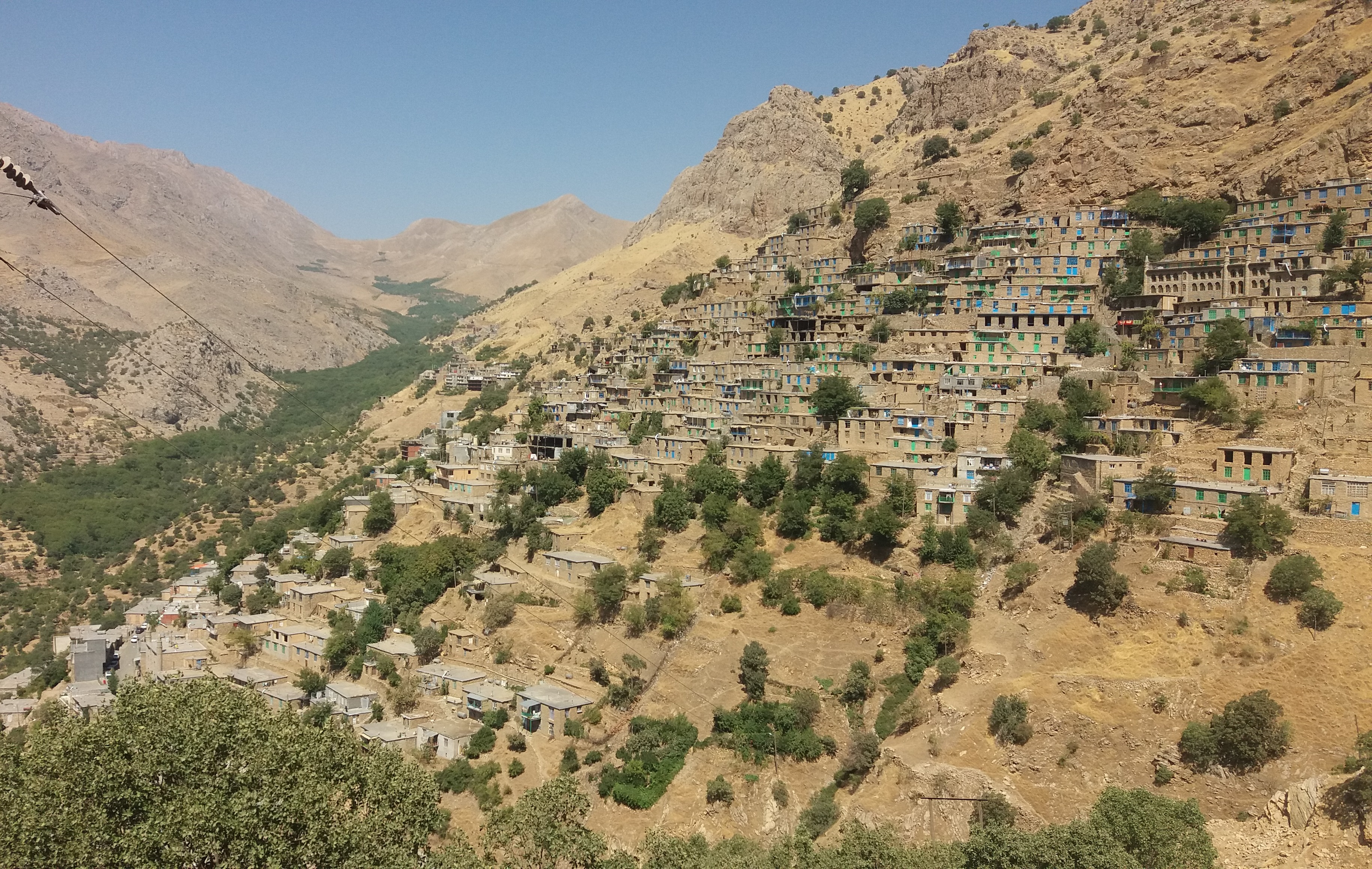
Cultural Landscape of Uramanat
From above, the villages look impossible. Stone houses stack against near-vertical mountainsides, each home's flat roof serving as the courtyard of the one above it. Twelve settlements climb the slopes of the Zagros Mountains in western Iran this way, built by the Hawrami people, an agropastoral Kurdish tribe who have farmed this landscape since roughly 3000 BCE. There is almost no flat ground. Every terrace, every garden, every path has been carved or coaxed from rock and steep terrain across five millennia of continuous habitation. In 2021, UNESCO inscribed the Cultural Landscape of Hawraman as Iran's 26th tangible World Heritage site, recognizing what the Hawrami already knew: that the relationship between these people and this unforgiving land is itself a masterwork.
Architecture Born from Scarcity
The villages of Uramanat solve a problem that most cultures never face. In flat river valleys, towns spread outward. Here, where productive land barely exists, communities built upward against the mountain itself. Houses are integrated with the slope so completely that the distinction between architecture and terrain dissolves. Walls become retaining structures. Rooftops become public spaces. Agricultural terraces step down the mountainside in narrow bands, wresting patches of cropland from gradients that would defeat conventional farming. The 12 villages included in the World Heritage property span the provinces of Kermanshah and Kurdistan along Iran's western border, with related settlements extending into the Halabja Governorate of Iraqi Kurdistan. Each village demonstrates a different response to the same constraint: how to sustain a community where the earth tilts away beneath your feet.
Forty Thousand Years of Footprints
The Hawrami are relative newcomers. Human presence in this landscape reaches back to the Paleolithic. Archaeological excavations conducted under the Darian Dam Archaeological Salvage Program uncovered a sequence of sites spanning tens of thousands of years. Kenacheh Cave, in the Perdi Mala valley, yielded evidence of Upper Paleolithic occupation. The Darai Rockshelter contained Middle Paleolithic remains. Sar Cham produced artifacts from both the Chalcolithic and Iron Age periods, while the Ruwar tomb dates to the Iron Age. Tragically, all excavated sites except Ruwar were flooded when the Darian Dam reservoir filled in 2015 and 2016. The salvage program preserved what knowledge it could before the water rose. What remains is evidence that this remote corner of the Zagros has drawn human habitation for roughly 40,000 years, making the Hawrami's five millennia only the most recent chapter in a far longer story.
Empires Passing Through
The Zagros Mountains were never as isolated as they appear. An inscription carved by Sargon II, King of Assyria from 721 to 705 BC, survives at Tang-i Var pass near the village of the same name. It records Assyrian military campaigns into the mountains, evidence that even the great Mesopotamian empires found reason to push into this difficult terrain. Centuries later, in 1909, three parchment documents were discovered in a cave on Kuh-e Salan Mountain near the village of Shar Hawraman. Known as the Parchments of Avroman, they date from 88 BC to 33 AD, spanning the Seleucid and Parthian eras. Two are written in Greek, one in Parthian. They record mundane transactions, the sale of a vineyard, the transfer of land, naming individuals like Pataspak son of Tiren and Awil son of Baenin. These ordinary documents, preserved in a mountain cave for two thousand years, reveal that even in this remote landscape, people bought and sold property, wrote contracts, and conducted the business of daily life under the shadow of distant empires.
Living Heritage on the Edge
What distinguishes Uramanat from an archaeological site is that people still live here. The Hawrami continue their agropastoral traditions, combining animal husbandry with the steep-slope agriculture that defines their landscape. Their responses to the scarcity of productive land have evolved across millennia but never fundamentally changed. Terracing, vertical construction, and an intimate relationship with the mountainside remain the basis of Hawrami life. UNESCO's inscription at the 44th session of the World Heritage Committee recognized this continuity as the site's core value. The landscape is not preserved ruins or abandoned fields. It is an ongoing conversation between a people and their environment, carried on in the same steep valleys, using many of the same techniques, for five thousand years. The Hawrami did not build monuments to impress outsiders. They built homes that grip the mountain because there was no other way to live.
From the Air
Located at 35.11N, 46.48E in the Zagros Mountains along the Iran-Iraq border, spanning Kermanshah and Kurdistan Provinces. The stacked villages are visible on steep mountain slopes, best seen from 4,000-8,000 feet AGL. The nearest significant airports are Kermanshah (OICC/KSH) to the south and Sanandaj (OICS) to the north. The terrain is extremely mountainous with narrow valleys; expect significant turbulence and limited emergency landing options. The villages appear as terraced clusters against otherwise uninhabited slopes. Morning light best illuminates the west-facing settlements.