Curacao
The houses are wrong. That's the first thought crossing the Queen Emma pontoon bridge into Willemstad's Punda district. The gabled facades are unmistakably Dutch - the same steep rooflines you'd find along an Amsterdam canal - but someone has painted them mango yellow, coral pink, seafoam green, and a shade of blue that matches the liqueur this island gave its name to. The legend says a colonial governor with sensitive eyes once ordered all white buildings repainted in color to reduce the glare. Whether or not that's true, the result earned Willemstad's historic center a UNESCO World Heritage designation, and it remains one of the most photographed waterfronts in the Caribbean. But Curacao is more than its architecture. Forty-four miles long and never more than seven wide, this arid island just north of Venezuela has spent five centuries absorbing Dutch governance, African culture, and Caribbean sun, producing something that resists categorization. The language isn't Dutch. The food isn't quite Caribbean. The weather - year-round warmth with almost no hurricanes - isn't what anyone expects from the tropics.
The Language Nobody Expected to Survive
Papiamentu defies the usual trajectory of creole languages. Born from the collision of Portuguese, Spanish, Dutch, English, French, and West African tongues during the colonial era, it was supposed to fade as proper education replaced it with Dutch. Instead, it took over. On Curacao today, Papiamentu is the first language nearly everyone speaks at home, the language of radio and pop music, the language lovers argue in. Dutch holds its ground in courtrooms and classrooms, but Papiamentu is the island's emotional mother tongue. The word dushi - meaning good, sweet, beautiful, delicious, darling, all at once - tells you everything about its character. The language became co-official in 2007. Most Curacaoans move between three or four languages in a single conversation without thinking about it, switching codes the way other people switch gears.
Bitter Oranges and Blue Bottles
Spanish colonizers brought Valencia orange trees hoping to establish citrus plantations. The trees survived the arid climate but produced fruit that was small, bitter, and commercially useless - or so everyone assumed. The Laraha orange, as the mutant citrus came to be called, turned out to have extraordinarily aromatic peels. In the nineteenth century, the Senior family began distilling those peels into a liqueur that would bear the island's name. Blue Curacao gets its famous hue from food coloring, not from the oranges themselves - the base spirit is clear. The Chobolobo estate where the Senior family still produces the genuine article also makes orange, green, and uncolored versions. The Laraha remains unique to the island; attempts to cultivate it elsewhere have failed, as though the fruit insists on staying home. A failed colonial agriculture experiment became a globally recognized brand.
Underwater Cathedrals
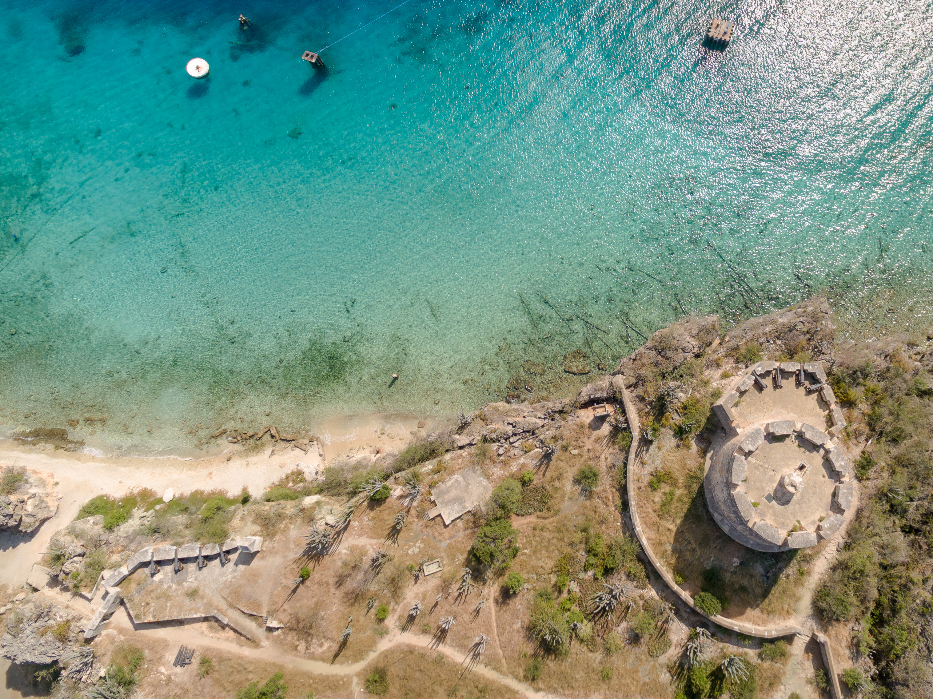
Curacao drops steeply into the Caribbean Sea. Where most islands taper into shallow sandy shelves, the southern coast plunges to depth within meters of shore, creating wall dives accessible without a boat. The reef system is healthier than much of the wider Caribbean, partly because the island's aridity means fewer rivers carry sediment onto the coral. Mushroom Forest, on the western end, features massive star coral formations grown into mushroom-shaped pillars over centuries. The Tugboat, a deliberately sunken vessel near Spanish Water, sits shallow enough for snorkelers to peer down at the encrusted hull. Visibility regularly exceeds 30 meters. Because the island lies outside the hurricane belt - no hurricane has made landfall since the National Hurricane Center began tracking - the reefs have been spared the periodic devastation that sets back coral growth elsewhere. Clarity, accessibility, and reef health make Curacao one of the Caribbean's most rewarding diving destinations, though it remains quieter than Bonaire next door.
The Snack on Every Corner
Curacao's food culture borrows from everywhere and apologizes to no one. Indonesian satay and peanut sauce arrived via Suriname, another former Dutch colony. Dutch cheeses sit next to Venezuelan arepas. And scattered across every neighborhood are the establishments locals simply call snacks - small bar-restaurants serving Chinese food that double as convenience stores and stay open later than anything else. At Plasa Bieu in the Punda district, market stalls serve what many consider the island's best local food: stoba stew, funchi cornmeal cakes, and fresh-caught fish, dished up cafeteria-style to office workers on lunch break. The genuine cuisine lives in these unglamorous settings, not in the waterfront restaurants aimed at cruise ship passengers. The fusion happened naturally, because people from everywhere ended up on the same small island and started feeding each other.
A Floating Bridge and an Open Harbor
The Queen Emma pontoon bridge, connecting Punda and Otrobanda across St. Anna Bay, swings open whenever a ship needs to pass. Pedestrians mid-crossing wait on whichever side they happen to be standing, watching vessels glide through the narrow channel into the Schottegat. This harbor is the reason Curacao matters. The Dutch West India Company chose the island in 1634 not for its farmland - there was almost none - but for the Schottegat, one of the finest natural harbors in the Caribbean. It served as a hub for the slave trade, a military base, an oil refinery port, and today handles cruise ships and cargo. Willemstad grew on both banks, Punda for commerce and Otrobanda for residences, with the swinging bridge connecting them since 1888. When it opens, life pauses. People lean on railings and watch. On an island where the temperature holds at 27 degrees year-round and hurricanes don't come, there is no urgency that a passing ship cannot postpone.
From the Air
Located at 12.20°N, 69.00°W, Curacao stretches roughly 64 km (40 mi) east-west and up to 11 km (7 mi) north-south. Curacao International Airport / Hato (TNCC) sits on the northern coast with a 3,410m runway, one of the longest in the Caribbean, capable of handling wide-body aircraft. From approach altitude, Willemstad's harbor entrance at St. Anna Bay is clearly visible on the southern coast - look for the narrow channel cutting into the Schottegat lagoon. The island appears flat and arid from above, with sparse scrubby vegetation and prominent cactus cover, in stark contrast to lush tropical islands elsewhere in the Caribbean. The southern coast has calmer waters; the northern coast faces open ocean with rougher conditions. Aruba lies approximately 72 km to the west, Bonaire 68 km to the east, and the Venezuelan mainland about 65 km to the south. Expect steady easterly trade winds at 15-25 knots and generally excellent visibility. The island lies below the hurricane belt.