Cypress Street Viaduct
At 5:04 p.m. on October 17, 1989, the upper deck of the Cypress Street Viaduct dropped onto the lower deck like a closing book. The 1.6-mile double-decked freeway, part of the Nimitz Freeway in West Oakland, had been carrying rush-hour traffic in both directions when the Loma Prieta earthquake -- magnitude 6.9 -- shook the Bay Area for fifteen seconds. Forty-two people died in the collapse. But here is the fact that haunts the story: the San Francisco Giants and Oakland Athletics were about to play Game 3 of the World Series that evening. Thousands of commuters who would normally have been on the Cypress Structure at 5:04 had left work early or lingered at the office with the television on. The baseball game that never started may have saved hundreds of lives.
Built Through the Neighborhood
The Cypress Street Viaduct was born from a 1949 plan by the City of Oakland to ease traffic on local streets feeding the San Francisco-Oakland Bay Bridge. The route along Cypress Street through West Oakland was, by some accounts, deliberately chosen to displace communities the city regarded as slums -- a pattern of highway construction through Black and low-income neighborhoods repeated in cities across America throughout the 1950s. Construction began in phases: contractors Frederickson and Watson completed the southern off-ramp section in October 1955 at a cost of $1.7 million, and a second phase built the double-decked portion from Adeline Street to the MacArthur Maze for $8.3 million. When California's first double-decked freeway opened to traffic on June 11, 1957, it was an engineering novelty -- four lanes per tier, reinforced concrete, a structure that carried southbound traffic on top and northbound beneath.
Fifteen Seconds
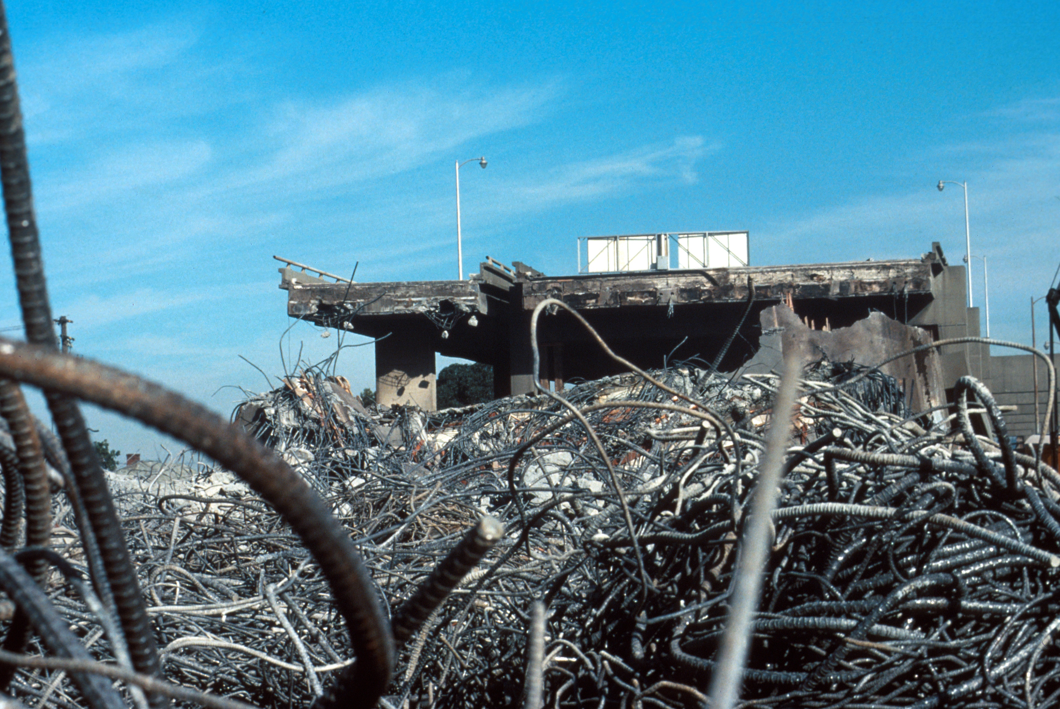
The earthquake struck sixty miles south, near Santa Cruz, but the geology beneath West Oakland amplified the violence. The viaduct stood on filled land layered over bay clay -- a combination that intensifies ground motion during seismic events and makes soil settlement severe. The structural flaws compounded the problem: exterior columns on the upper deck were not tied by reinforcing steel to the columns below, and the columns lacked sufficient ringing to prevent them from bursting outward under lateral force. A modest earthquake retrofit in 1977 had not addressed these fundamental weaknesses. From 16th Street north to the MacArthur Maze, the upper deck pancaked down. Some sections had been supported by just a single central column. The engineering failures were later found to mirror those of the Hanshin Expressway in Kobe, Japan, which would collapse in a 1995 earthquake with eerily similar characteristics.
Into the Wreckage
When the shaking stopped, there was no aftershock -- an unusual mercy. Residents of the surrounding West Oakland neighborhood and workers from nearby businesses did not wait for emergency crews. They climbed into and onto the shattered concrete, pulling survivors from the compressed space between the decks. Some people trapped in crushed vehicles could only be freed by amputation of pinned limbs. The rescuers worked in fading daylight, then in darkness. The 42 deaths accounted for two-thirds of the earthquake's total toll of 63 fatalities across the Bay Area. Initial fears had put the number far higher. But the World Series had thinned the commute: the viaduct at 5:04 p.m. on a Tuesday in October carried a fraction of its normal traffic. The coincidence was grim arithmetic -- fewer cars meant fewer people entombed between the decks -- but it was real. Baseball, of all things, had reduced a catastrophe to something slightly less than total.
Mandela Parkway Rises
After the viaduct was demolished, the question was not whether to rebuild, but where. West Oakland residents, who had lived with the roaring double-decked freeway overhead for three decades, did not want it back. The replacement Nimitz Freeway, completed in stages through 2001, was rerouted to loop around the neighborhood using a largely ground-level design. The cost doubled from an initial estimate of $650 million to $1.2 billion -- at the time, the most expensive highway project in California history. The overruns stemmed partly from the complexity of purchasing land from the Southern Pacific Railroad, relocating Amtrak rail facilities, and rerouting through the Oakland Army Base. Where the viaduct once stood, Cypress Street was renamed Mandela Parkway, in honor of Nelson Mandela, and a landscaped median was planted along its length. The Cypress Freeway Memorial Park now occupies the corner of 14th Street and Mandela Parkway, a quiet green space where concrete once stacked upon concrete.
What the Ground Remembers
During construction of the replacement freeway, archaeologists made unexpected discoveries about the people who had lived in West Oakland in the 19th century, unearthing artifacts from communities whose stories the original freeway had paved over. It was an accidental archaeology of displacement: the earthquake that destroyed the viaduct also opened a window into the neighborhood the viaduct had helped destroy. Today, Mandela Parkway is lined with trees where exhaust once hung in shadows. The memorial park is modest -- no towering monument, just green space and memory. President George H. W. Bush toured the wreckage with Oakland Mayor Lionel J. Wilson in the days after the earthquake. The photographs show two men staring at broken concrete. What the photographs do not show is what the neighborhood gained in the decades that followed: light, air, and the ground itself, returned.
From the Air
Located at 37.82°N, 122.29°W in West Oakland, California. The former viaduct route is now Mandela Parkway, visible as a tree-lined boulevard running north-south through West Oakland. The MacArthur Maze interchange is immediately to the north, and the San Francisco-Oakland Bay Bridge approach is visible to the west. Best viewed at 1,500-3,000 feet AGL. Nearest airports: Oakland International (KOAK) approximately 5 nm south, San Francisco International (KSFO) approximately 12 nm southwest. The replacement I-880 freeway loops around the west side of the neighborhood at ground level.