Damghan
The name means "village of the Magi." Zoroastrian priests gave Damghan its identity millennia ago, and the city has been accumulating layers of civilization ever since -- seven thousand years of them, stacked in the archaeological mound of Tepe Hissar like pages in a book no one has finished reading. Sitting at 1,250 meters elevation on the old highway between Tehran and Mashhad, Damghan occupies one of the longest-inhabited spots on the Iranian plateau. Empires have risen and fallen around it. Earthquakes have leveled it. Afghan invaders burned it. And still it persists, a quiet city of 59,000 known today for its pistachios and paper-thin almonds, its Seljuk minarets, and a mosque that was once a Zoroastrian fire temple.
Seven Millennia Underground
Southeast of the modern city, the archaeological mound of Tepe Hissar holds the oldest evidence of Damghan's occupation. Radiocarbon dating has yielded artifacts 7,000 years old. The site was inhabited during the Chalcolithic period in the fifth millennium BC, and metal production was already underway in its earliest layers. Ernst Herzfeld identified the site and proposed it for excavation. Erich Schmidt then led two seasons of digs in 1931 and 1932, on behalf of the University of Pennsylvania Museum. A 1994 excavation supervised by Ehsan Yaghmai revealed remains spanning from the initial settlement of the Iranian plateau around 4000 BCE through the Median, Arsacid, and Sassanid periods. During railway expansion work nearby, construction crews uncovered the remains of a woman and her unborn child, both approximately 7,000 years old. The layers keep going down, and each one tells a different story -- Median civilization sharing traits with Mesopotamia, Achaemenid administration, Parthian commerce, Seleucid influence. Tepe Hissar reached its peak during the Seleucid and Parthian eras, when this stretch of the Iranian plateau was a crossroads of trade and power.
The City of a Hundred Gates
Southwest of Damghan lie the ruins of Hecatompylos -- the "City of a Hundred Gates" -- stretching from the village of Forat some 26 kilometers south to nearly 32 kilometers westward. After Alexander the Great's conquest of Persia, Hecatompylos became the regional population center, an important stop on the routes connecting Mesopotamia to Central Asia. The Greeks gave it a name previously bestowed on both Thebes in Greece and Thebes in Egypt, a mark of its perceived grandeur. Damghan eventually supplanted it. The city's own name, a compound of "deh" (village) and "moghan" (Magi), was given by Zoroastrians, the same religious tradition that produced Cyrus and Darius. By the first century AD, Damghan had become capital of the province of Qumis, a vast territory stretching from Sabzevar to Garmsar, bounded by the Alborz Mountains to the north and the Lut Desert to the south.
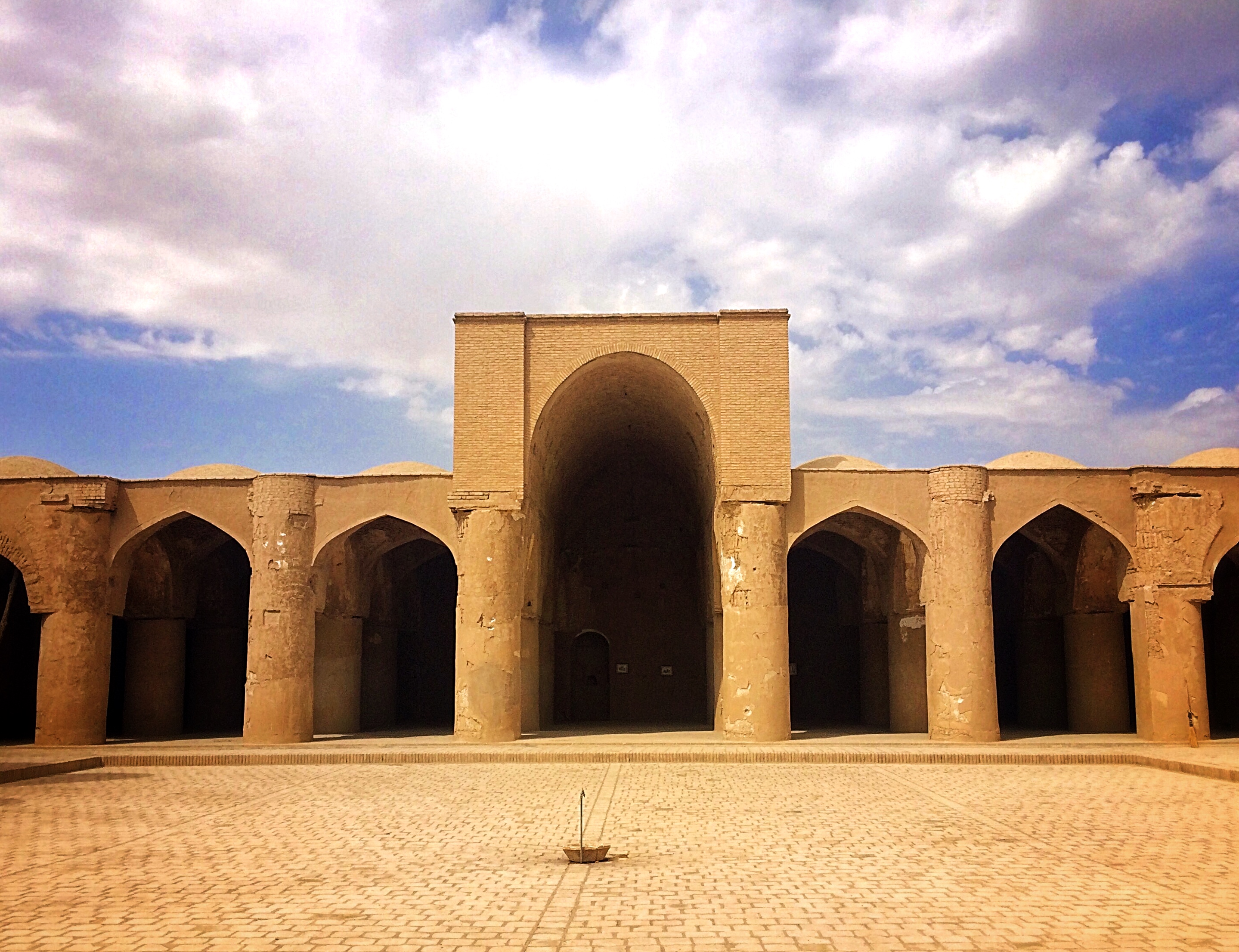
Fire Temple Turned Mosque
The Tarikhaneh is Iran's oldest mosque, and it began as something else entirely. Built as a Zoroastrian fire temple during the Sassanid period, it was converted to Islamic worship after the Arab conquest of Persia in the seventh century. The name itself bridges cultures: "Tari" is a Turkish or Mongol word meaning God, and "khaneh" is Persian for house. The building blends Roman, Byzantine, Iranian, and Arabic architectural traditions. Its open courtyard and colonnaded arcade follow the same Arab hypostyle plan as the Prophet's Mosque in Medina, making it one of the earliest surviving examples of that foundational Islamic architectural form. A square courtyard faces a gallery of 18 massive columns oriented toward the qibla. At least one column in the eastern wing preserves unmistakably Sassanian proportions, a physical reminder of the building's pre-Islamic origins. The minaret dates to the Seljuk period, and the tiled inscription adorning it is considered the oldest surviving tilework in Islamic architecture.
Fortresses of the Assassins
About 15 kilometers west of the city, perched on the circular peak of Gerdkuh, stands one of the most dramatic ruins in Semnan Province. This was a fortress of the Hashshashin -- the Ismaili order that the Crusaders called the Assassins -- used by Hassan-i Sabbah as part of his network of mountain strongholds. The peak's round shape, which gave Gerdkuh its name ("round mountain"), made it nearly impregnable. It held out until the Mongol Ilkhanate under Hulagu Khan finally took it. Twenty-two kilometers farther north, on the pyramidal peak of Mansourkuh, sits Mehrnegar Fort, another Ismaili fortification named for a princess whose love story became local legend. Between these mountain forts and the city, the road passes through Cheshmeh-Ali, an evergreen spring 30 kilometers north of Damghan where Qajar-era palaces still stand among the foliage. Fath-Ali Shah's palace rises from an artificial pool between the first and second springs, a pleasure retreat built over one of the oldest water sources in the region.
What Survives and What Was Lost
Damghan has been destroyed more than once. The 856 earthquake leveled half the city. The Afghan Hotak dynasty destroyed it again in 1723. Yet the Seljuk period left treasures that neither disaster erased: the Gunbad-i Pir-i Alamdar tomb, the Gunbad-i Chihil Dukhtaran mausoleum (the second-oldest tomb from the reign of Tughril, first of the Seljuk sultans), the congregational mosque with its decorated minaret. These buildings introduced brick ornamentation to Iranian architecture, breaking the monotony of plain masonry with geometric patterns that influenced centuries of construction. Sasanian-era fortification walls, once wide enough for chariots, survive in fragments north and south of the city. The bazaar still contains old schools, baths, and tombs. Foreign archaeologists have excavated here extensively, and many of the finest finds now reside in British and French museums -- a fact that adds another complicated layer to Damghan's long story of things built, lost, and carried away.
From the Air
Located at 36.17N, 54.35E in Semnan Province, Iran, at 1,250 meters elevation on the Tehran-Mashhad highway. From altitude, Damghan appears as a compact city on the arid plain south of the Alborz Mountains. Tepe Hissar is visible as a raised mound southeast of the city. The ruins of Hecatompylos extend southwest toward Forat. The Gerdkuh fortress is visible to the west along the Semnan road. Mansourkuh lies to the north along the road toward Mazandaran. Nearest airport is Semnan Airport (OIIS), approximately 180 km west. Shahroud Airport lies to the east. Best viewed in clear conditions when the contrast between mountain and desert terrain is sharpest.