Damodar River
The name itself carries a warning and a myth. Damodar derives from Sanskrit -- dama meaning 'rope' and udara meaning 'belly' -- translating to 'rope around the belly.' It is also a name for the Hindu god Krishna, given because his foster-mother Yashoda once tied the mischievous young deity to a large urn. But the people of Bengal needed no mythology to understand the Damodar's temperament. For centuries, this rain-fed river flowing 368 miles from the Khamarpat Hill on the Chotanagpur Plateau through Jharkhand and West Bengal before joining the Hooghly at Howrah brought annual devastation so reliable it entered the region's folk songs. Farmers in the floodplain composed Bhadu songs pleading with the river to reduce its fury, singing: 'O Damodar! We fall at your feet / Reduce the floods a little.'
A Calendar of Catastrophe
The Chota Nagpur Plateau receives around 1,400 millimeters of rainfall annually, nearly all of it compressed into the monsoon months between June and August. When the rains came, the Damodar and its tributaries -- the Barakar, Konar, Bokaro, Jamunia, and others -- transformed from rivers into weapons. In the upper valley, water descended the hills with enough force to sweep away everything in its path. The Barakar alone destroyed two bridges on the Grand Trunk Road near Barhi in Hazaribagh district: a great stone bridge in 1913 and the iron bridge that replaced it in 1946. In the lower valley, the Damodar simply overflowed, inundating the districts of Bardhaman, Hooghly, Howrah, and Medinipur. The record of major floods reads like a grim almanac: 1770, 1855, 1866, 1873-74, 1875-76, 1884-85, 1891-92, 1897, 1900, 1907, 1913, 1927, 1930, 1935, and 1943. In four of those years -- 1770, 1855, 1913, and 1943 -- most of Bardhaman town went underwater.
Embankments and Emperors
Efforts to control the Damodar date back to the colonial era, though they began not with engineering but with contract law. In 1789, Maharaja Kirti Chand of Burdwan signed an agreement with the East India Company, committing to pay an additional sum for the construction and maintenance of embankments to prevent floods. The arrangement proved contentious. Disputes over costs and responsibilities festered for decades until the Bengal Embankment Act was passed in 1866 and amended in 1873, transferring the power to build and maintain flood defenses from local rulers to the colonial government. But embankments alone could not contain a river whose catchment area spans 24,235 square kilometers across what are now the states of Jharkhand and West Bengal. The Damodar required something more ambitious -- and independence would provide the opportunity.
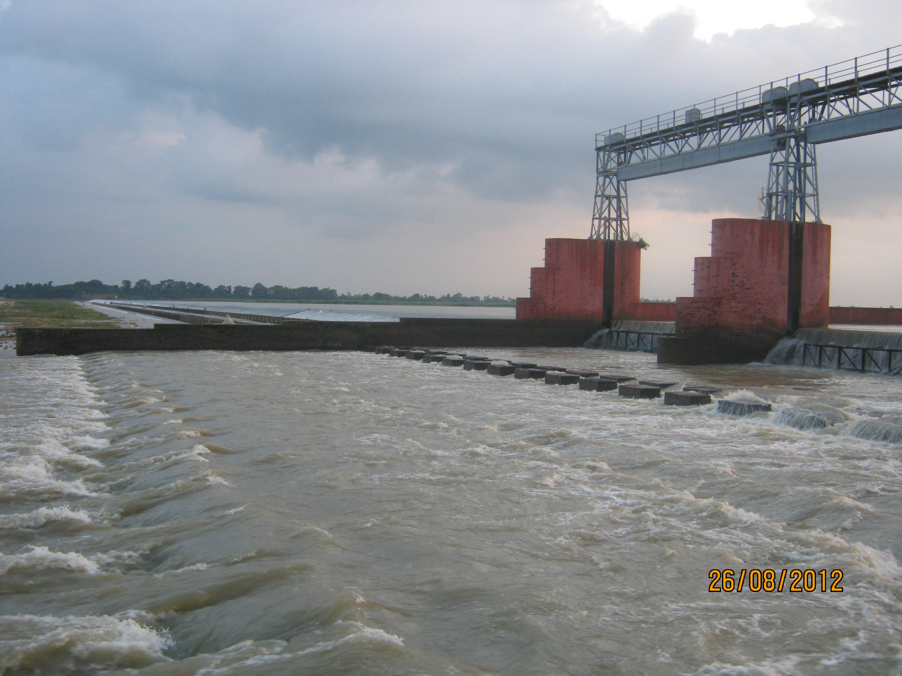
India's Tennessee
On July 7, 1948 -- less than a year after independence -- the Constituent Assembly of India passed Act No. XIV, creating the Damodar Valley Corporation. It was the first multipurpose river valley project of independent India, modeled explicitly on the Tennessee Valley Authority of the United States. The DVC's mandate was sweeping: flood control, irrigation, hydroelectric power generation, eco-conservation, afforestation, and job creation for the communities that had suffered the river's wrath for centuries. The first dam rose across the Barakar River at Tilaiya in 1953. The Konar Dam followed in 1955. Two more dams were built at Maithon in 1957 and Panchet in 1958, both positioned about eight kilometers upstream of where the Barakar and Damodar converge. The Durgapur Barrage, constructed in 1955, completed the initial system, feeding an extensive network of canals and distributaries that transformed flood management into irrigation. Together, the dams can moderate peak floods, and the DVC has created an irrigation potential of 3,640 square kilometers.
The Ruhr of India
Taming the floods unlocked something else entirely. The Damodar Valley sits atop massive coal deposits -- 2,883 square kilometers of the central basin constitute the prime center of coking coal in India. Coalfields at Jharia, Raniganj, West Bokaro, East Bokaro, Ramgarh, South Karanpura, and North Karanpura fueled an industrial transformation that earned the valley its comparison to Germany's Ruhr region. Three integrated steel plants operated by the Steel Authority of India Limited -- at Bokaro, Burnpur, and Durgapur -- anchor an industrial corridor that makes the Damodar Valley one of the most heavily industrialized stretches of the Indian subcontinent. The river that once destroyed now powers. Its water generates hydroelectricity, irrigates farmland, and cools steel furnaces. The sorrow of Bengal became the engine of Bengal, though the Damodar's old temperament has not been entirely forgotten -- in 1978, outside DVC control, the government of Bihar built the Tenughat Dam as additional insurance against the river's memory of wildness.
From the Air
Located at 22.28N, 88.08E where the Damodar meets the Hooghly near Howrah, West Bengal. The river is visible as a major water feature flowing east-southeast from the Chotanagpur Plateau across Jharkhand and West Bengal. Multiple dams along its course (Tilaiya, Konar, Maithon, Panchet, Durgapur Barrage) are identifiable landmarks. The industrial cities of Durgapur, Burnpur, and Bokaro line the valley. Nearest major airport is Netaji Subhas Chandra Bose International Airport, Kolkata (VECC), approximately 30 km to the east. Kazi Nazrul Islam Airport, Durgapur (VEDG), serves the upper valley. At 5,000-8,000 feet, the full course of the river and its dam system become visible, with coal mining operations creating distinctive dark patches in the landscape.