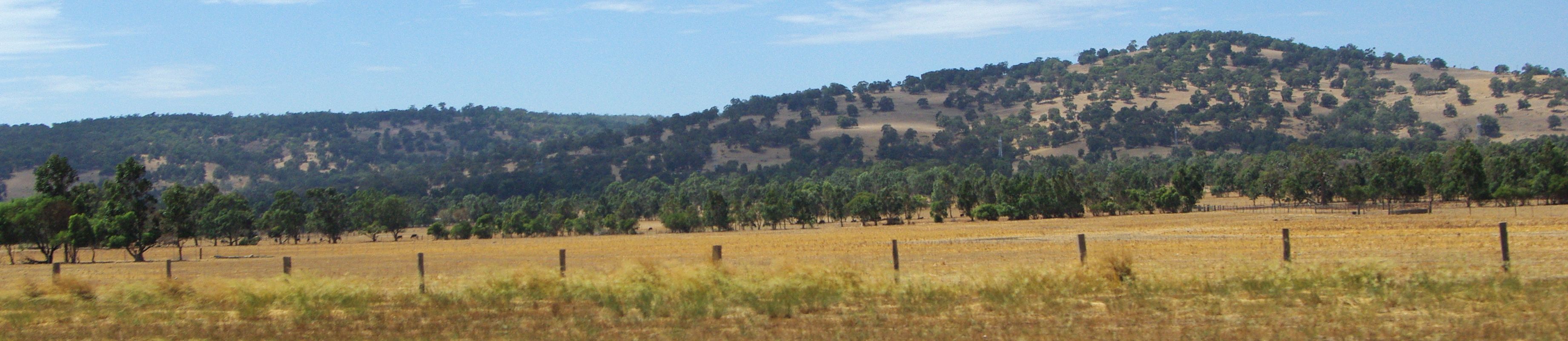
Darling Scarp
From space, the boundary is unmistakable: a sharp line of dark green running north to south, hundreds of kilometres long, marking where dense forest meets the pale coastal plain below. This is the Darling Scarp, and the abruptness of that edge is no accident. It traces one of Australia's most ancient geological fractures, the Darling Fault, a discontinuity so old it separates rock formations billions of years apart in age. Perth's residents know it simply as "the Hills" - the forested ridge that catches afternoon thunderstorms, feeds their reservoirs, and glows amber at sunset. But the scarp is far more than a scenic backdrop. It is the reason Perth has water, the reason jarrah forests survive, and one of the longest continuous escarpments on the continent.
A Fracture in Deep Time
The Darling Scarp owes its existence to the Darling Fault, exposed for over 1,000 kilometres from Shark Bay to Albany. On its eastern side sit the Archaean granites and gneisses of the Yilgarn craton, some of Earth's oldest continental crust. To the west lies the younger Perth Basin, the sandy limestone and dune sand on which the city itself is built, including Pleistocene dunes formed during the last ice age. The scarp once sat directly atop the fault, but erosion has pushed it roughly 15 kilometres eastward over geological time. Its original position is still readable in the landscape as the Ridge Hill Shelf, a subtle terrace that geologists use to reconstruct the escarpment's ancient profile. Government Botanist Charles Fraser first recorded it as "General Darling Range" in March 1827, naming it for the Governor of New South Wales, Lieutenant-General Ralph Darling.
Perth's Green Reservoir
Rainfall along the scarp averages 1,300 millimetres annually, far more than the plain below. That moisture, funnelled through valleys of jarrah and marri forest, made the escarpment Perth's natural water tower. By the early twentieth century, most rivers flowing off the scarp had been dammed: Mundaring Weir on the Helena River, Serpentine Dam on the Serpentine, Canning Dam on the Canning, and several others feeding a network that today supplies over two million people. The geology makes this possible but also complicates it. Hypersaline groundwater trapped in the ancient Yilgarn granite can seep into the base of reservoirs, forcing periodic flushing to maintain water quality. The scarp also marks the eastern limit of the Perth Basin's aquifers, including the Southwest Yarragadee, drawing a hydrological line as precise as the geological one beneath it.
Forest Under Siege
The jarrah-marri forest clothing the scarp belongs to one of the world's recognized biodiversity hotspots. Jarrah, marri, bullich, and blackbutt create a layered canopy over valleys that shelter rare orchids, black cockatoos, and the endangered chuditch. But the same laterite soils that grow jarrah also contain bauxite, and since the late twentieth century, mining proposals have provoked fierce public opposition. Groups like the Campaign to Save Native Forests forced government and miners to renegotiate boundaries. Today the major Huntly and Willowdale mines operate under strict rehabilitation requirements. A parallel threat comes from Phytophthora cinnamomi, the dieback pathogen that kills jarrah from the roots up. Only vehicle access restrictions have slowed its spread, a fact that gained public attention when Rally Australia agreed to pressure-wash every car, undercarriage included, at the end of each stage run through forest service roads.
Railways, Quarries, and the Climb East
Getting over the scarp was one of colonial Perth's defining engineering challenges. The Eastern Railway first crossed it in the 1880s through Greenmount, where quarries later exploited the railway's proximity. By the 1890s a second route passed through the Swan View Tunnel and John Forrest National Park. Not until the 1960s did a third route find easier grades through the Avon Valley. The Kalamunda Zig Zag, a switchback railway climbing the steep southern wall of the Helena Valley, operated until 1949 and remains a heritage walking trail. Quarries once scarred the escarpment's western face - Bluestone, Mountain, Statham's - extracting granite and shale for harbour works and brickmaking. Legislative restrictions in the late twentieth century halted new quarrying, and some former sites, like Mountain Quarry, have been repurposed as rock-climbing venues.
The Parks of the Darling Range
In 2005, a network of reserves scattered along the scarp was unified under the banner "Parks of the Darling Range," encompassing 23,948 hectares. Three years later, the parks received Noongar names reflecting the Indigenous cultural connection to this country: Beelu, Korung, Midgegoroo, Banyowla, Mundy, Wooroloo. These sit alongside older reserves like John Forrest National Park and Serpentine National Park, forming a green corridor that residents of Perth's eastern suburbs can reach in minutes. From the scarp's western edge, the view stretches across the Swan Coastal Plain to the Indian Ocean. Strong easterly winds rolling off the plateau create turbulence significant enough to trouble aircraft landing at Perth Airport - on 2 September 1999, wind shear from the scarp caused a Qantas 747's engine to strike the runway on approach. The scarp is a boundary in every sense: geological, hydrological, ecological, and atmospheric.
From the Air
Coordinates: 32.92S, 116.13E. The scarp runs as a continuous forested escarpment visible from altitude as a dark-green line east of Perth's urban sprawl. Best viewed at 3,000-5,000 ft AGL when approaching Perth from the east. Nearest major airport: YPPH (Perth Airport). The scarp's highest points are Mount Cooke (582 m) and Mount Dale (546 m). Multiple dams visible as blue features along the escarpment's valleys.