Dead Horse Point State Park
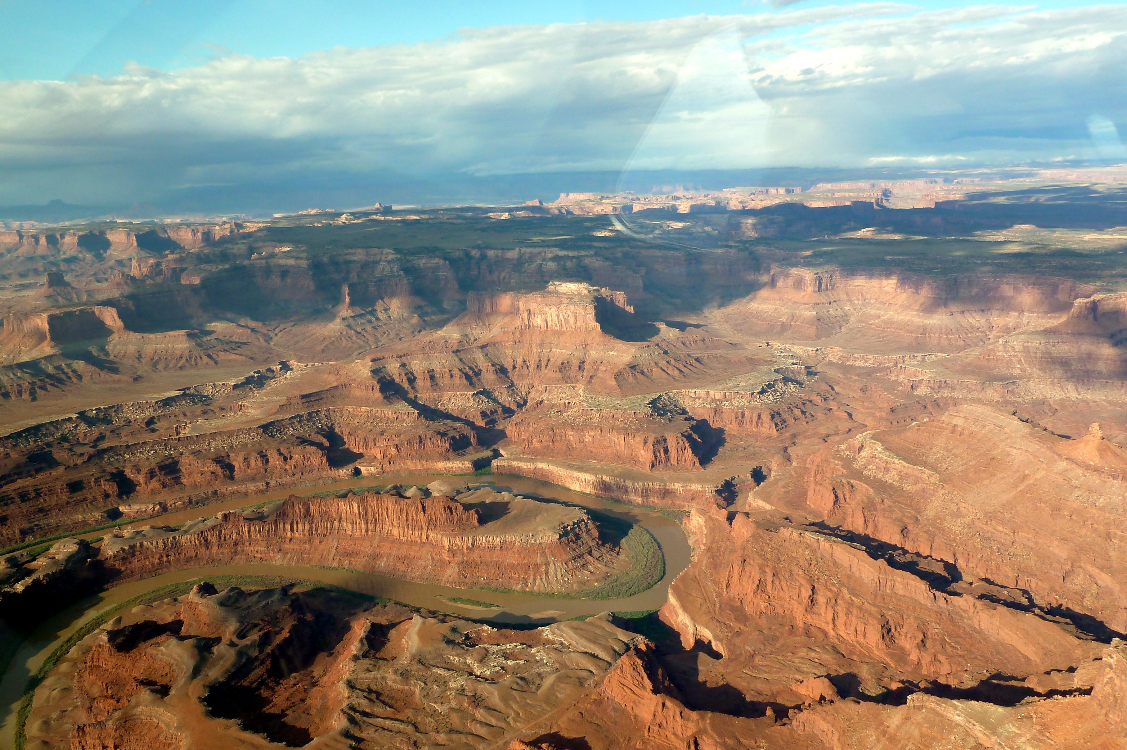
Dead Horse Point delivers what many consider the single most dramatic overlook in the American Southwest - a claim that requires justification given the competition. From this narrow peninsula of stone jutting out from the Colorado Plateau, visitors gaze down two thousand feet to where the Colorado River carves its way through the red rock layers, creating a gooseneck bend that photographers have made iconic. The point gets its dark name from cowboy legend: wranglers once used the peninsula's natural corral shape to trap wild mustangs, fencing off the narrow neck. According to the story, horses were left corralled here and died of thirst within sight of the river far below - a tale that may be apocryphal but captures the harsh beauty of this landscape. The view encompasses Canyonlands National Park, the La Sal Mountains, and the surreal blue pools of potash evaporation ponds - an industrial intrusion that has somehow become part of the scenery's appeal.
The View
The main overlook at Dead Horse Point faces south and east, encompassing a panorama that takes time to comprehend. The Colorado River appears as a brown ribbon impossibly far below, having carved through the same rock layers visible in the Grand Canyon - Navajo sandstone, Kayenta formation, Chinle group, Moenkopi formation - each telling millions of years of geological story. The gooseneck bend where the river nearly doubles back on itself creates the signature view. Beyond the river, Canyonlands National Park's Island in the Sky district spreads across the horizon, its mesas and buttes demonstrating erosion's patient artistry. The La Sal Mountains rise in the distance, snow-capped much of the year. And to the southeast, the distinctive turquoise rectangles of potash evaporation ponds provide unlikely visual interest - mining operations that have become photogenic features rather than eyesores.
Cowboy Legend
The peninsula that forms Dead Horse Point narrows to just thirty yards at its neck before widening again - a natural corral that cowboys recognized as useful for capturing wild mustangs. According to local tradition, wranglers would drive horses onto the point, fence off the narrow neck, and select the animals they wanted to keep. The remaining horses would be released, but on at least one occasion - the story goes - mustangs were left corralled and died of thirst despite the Colorado River being visible below. Whether this actually happened, or happened multiple times, or became conflated with other frontier stories, the name stuck. The legend suits the place: beautiful and brutal, a landscape that rewards but doesn't forgive, where the sight of water doesn't guarantee the ability to reach it.
Film and Fame
Dead Horse Point's photogenic qualities attracted Hollywood early. The opening sequence of 'Thelma and Louise' features the Utah canyon country, though not specifically this overlook. '127 Hours,' the story of climber Aron Ralston's self-amputation to escape a slot canyon, used nearby locations. Car commercials and calendar photographs have spread the image worldwide. The point has appeared in numerous films as a stand-in for generic southwestern grandeur. This exposure means that despite being 'just' a state park rather than a national park, Dead Horse Point draws substantial visitation - though nothing like the crowds at adjacent Arches. The overlook remains accessible to anyone willing to drive the scenic thirty miles from Moab, with the only requirement being the modest day-use fee.
Beyond the Overlook
While most visitors come for the main viewpoint and depart, Dead Horse Point offers more for those with time. The Rim Trail system provides hiking along the canyon edge with multiple overlooks providing different perspectives on the river and canyons. Mountain bikers can explore the Intrepid Trail System that winds through the mesa tops behind the point. The campground, limited to 21 sites, fills regularly with visitors who want to experience sunset and sunrise views without driving. Unlike Arches and Canyonlands, Dead Horse Point has modern facilities including flushing toilets and water fountains in the visitor center - minor conveniences that matter in desert heat. The mesa top supports a typical high desert ecosystem: pinyon pines, junipers, blackbrush, and the occasional mule deer.
Visiting the Point
Dead Horse Point lies roughly thirty miles from Moab via scenic roads shared with the Island in the Sky section of Canyonlands National Park. Most visitors arrive by car, though bicycle is possible for the fit and prepared. The park charges a modest day-use fee - a relative bargain for views this dramatic. Summer heat can be oppressive; temperatures exceed 100°F regularly, and shade is minimal. Spring and fall provide the most comfortable visiting conditions. Winter can bring snow that transforms the red rock landscape but may close roads temporarily. The main overlook is a short walk from the parking area, fully accessible. Allow at least an hour for the drive from Moab plus viewing time - longer if you plan to hike or photograph at multiple overlooks. Combine with Island in the Sky for a full day of canyon country scenery unmatched in the Southwest.
From the Air
Located at 38.51°N, 109.74°W in southeastern Utah near Moab. The point is visible from altitude as a narrow peninsula extending into the canyon system of the Colorado River. The distinctive gooseneck bend in the Colorado is identifiable, as are the turquoise potash evaporation ponds to the southeast. Canyonlands National Park's Island in the Sky district lies immediately to the south. Canyonlands Field Airport (CNY) near Moab is 30 miles away. Salt Lake City International Airport (SLC) is the nearest major airport, 250 miles northwest.