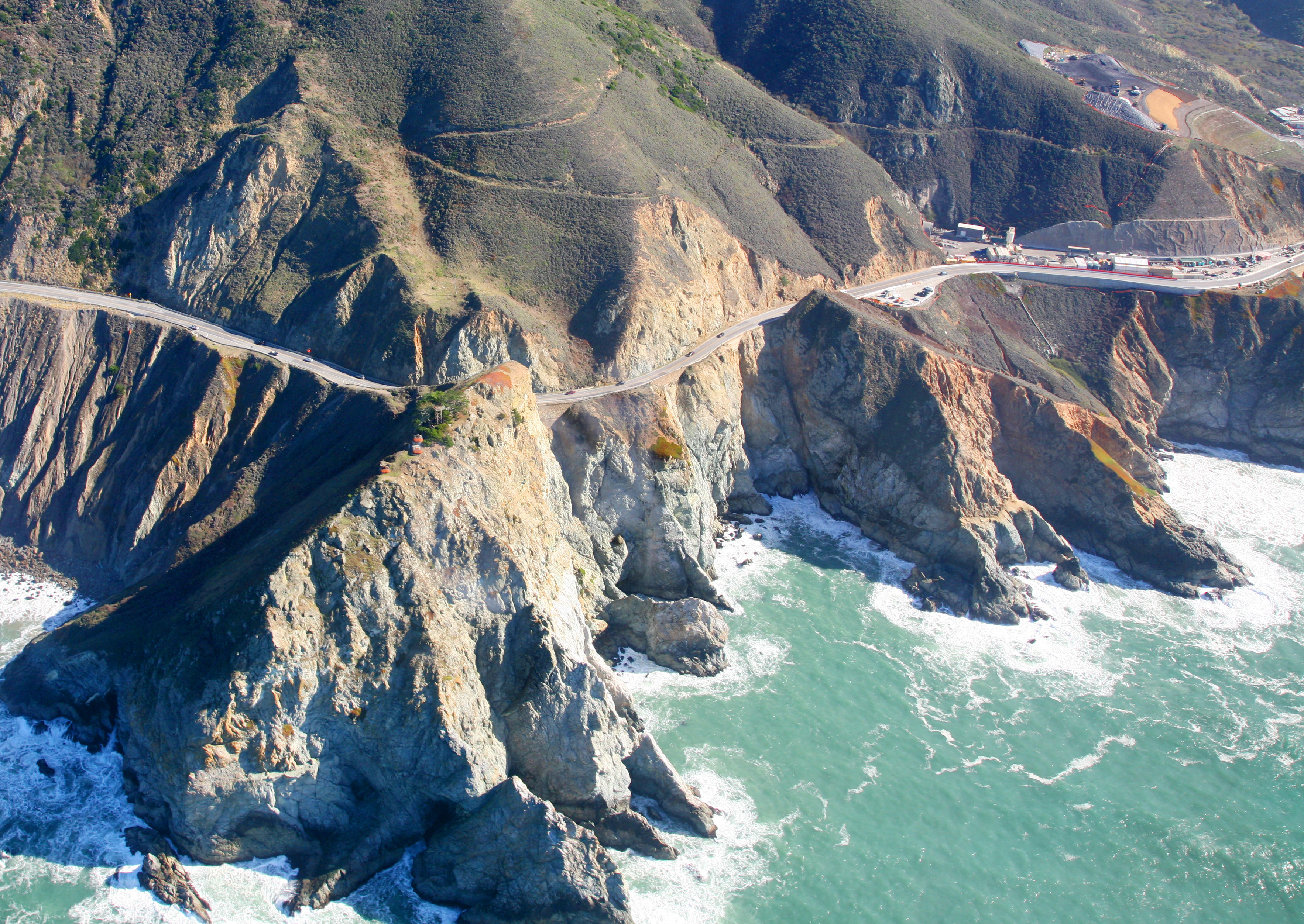
Devil's Slide
The mountain kept eating the road. Since Highway 1 was carved along the face of this coastal promontory in 1936, Devil's Slide has been trying to shrug it off. The first major landslide took much of the road in 1940. Another in 1995 closed it for nearly two years. In 2006, longitudinal cracks in the roadbed announced an imminent slide, shutting the highway for five months. Each time, Caltrans stabilized, repaired, and reopened, and each time the mountain made clear it would do this again. Finally, in 2013, California stopped fighting the geology and went through it instead, opening the Tom Lantos Tunnels behind the crumbling cliffs and turning the old highway into a 1.3-mile pedestrian and bicycle trail.
The Geography of Failure
Devil's Slide is a steep, rocky promontory on the San Mateo County coast, roughly midway between Montara and the Linda Mar district of Pacifica. Its terrain is characterized by eroded slopes with natural gradients between 30 and 50 percent, covered in dense northern coastal scrub. The name refers to the rocky edges that are prone to slope failure, a polite geological term for entire hillsides deciding to relocate to the beach below. The section of Highway 1 that ran along its face replaced the even more treacherous Pedro Mountain Road in 1936, but the new alignment was never stable. The road was originally part of the proposed route of the Ocean Shore Railroad, the ill-fated coastal rail line that operated from 1907 to 1920 without ever completing its planned route.
The Bunkers Above the Waves
Before it was a transportation headache, Devil's Slide was a military asset. During World War II, the promontory served as a triangulation station for the harbor defense of San Francisco. Before radar, military personnel used binoculars and compasses to search for ships at sea, relaying coordinates to a central post. By combining data from multiple observation sites, a ship's location could be determined by triangulation. Six structures were built at Devil's Slide: three concrete-and-steel observation pillboxes, two concrete-and-earth bunkers, and a reinforced steel observation tower. One bunker served as a communications and command post. The southernmost bunker site was sold to a private owner in 1983, but remnants of the exposed structures remain, slowly being reclaimed by the same coastal scrub that covers everything else.
Trail Above the Abyss
On March 25, 2013, Caltrans permanently closed the old highway alignment and opened the Tom Lantos Tunnels, which carry Highway 1 through the mountain behind the unstable cliffs. The abandoned road was converted into the Devil's Slide Trail, a paved 1.3-mile path that offers pedestrians and cyclists one of the most dramatic coastal walks in California. The trail follows the original highway alignment, hugging the cliff face with the Pacific crashing below and the endangered Hickman's potentilla growing on slopes above Martini Creek. On clear days, the views south toward Half Moon Bay and north toward Pacifica are unobstructed. On foggy days, which are frequent, the trail disappears into a white void where the only orientation comes from the sound of waves far below. The mountain no longer needs to fight the road. It has the trail now, and the trail asks for nothing.
From the Air
Located at 37.574°N, 122.520°W on the San Mateo County coast between Pacifica and Montara. The promontory is visible as a dramatic cliff face with the old highway/trail visible on its face. The Tom Lantos Tunnels portals are visible at the north and south ends. Nearest airport: Half Moon Bay Airport (KHAF), 5 nm south. KSFO is 10 nm northeast. Terrain rises steeply; maintain safe altitude.