Dhanushkodi
The train was carrying 115 passengers when the sea came for it. On the night of 22 December 1964, a cyclone tore across the narrow tip of Pamban Island and hit the town of Dhanushkodi with winds estimated at 280 kilometers per hour and tidal waves seven meters high. The Pamban-Dhanushkodi passenger train never arrived at the station. The station itself ceased to exist. By morning, approximately 1,800 people were dead, the town was submerged, and the Government of Madras declared Dhanushkodi a ghost town, permanently unfit for habitation. More than sixty years later, that declaration still stands.
The Town at Land's End
Dhanushkodi sits at the southeastern tip of Pamban Island, the last point of India before the shallow waters of the Palk Strait stretch toward Sri Lanka, just 24 kilometers away. The name means "bow's end" in Sanskrit, a reference to the Ramayana tradition that Lord Rama stood here and broke the tip of his bow after building the bridge to Lanka. For centuries the town served as a transit point between India and Ceylon. A metre-gauge railway connected it to Mandapam on the mainland, and the Boat Mail Express ran from Chennai Egmore all the way to this narrow spit of sand, where passengers transferred to ferries bound for Talaimannar in Sri Lanka. Dhanushkodi was small, remote, and alive with the traffic of two nations.
A Landscape Already Sinking
The Geological Survey of India documented something troubling well before the cyclone arrived. In 1948 and 1949, the southern portion of Dhanushkodi, facing the Gulf of Mannar, sank by nearly five meters due to vertical tectonic movement parallel to the coastline. A strip of land roughly half a kilometer wide and seven kilometers long slid beneath the sea. The town had been built on ground that was literally subsiding. When the cyclone formed as a tropical depression in the South Andaman Sea on 17 December 1964, Dhanushkodi was already geologically vulnerable, a sliver of sand balanced between two bodies of water on a foundation that had been dropping for years.
The Night of 22 December
The storm intensified into a cyclonic system as it crossed the Bay of Bengal. On 22 December, it passed over Vavuniya in Sri Lanka and made landfall at Dhanushkodi that night. The estimated wind velocity was 280 kilometers per hour. Tidal waves reached seven meters. The sea did not merely flood the town; it erased it. Approximately 1,800 people died, including the 115 passengers and crew aboard the passenger train from Pamban. The railway line from Pamban to Dhanushkodi was destroyed completely, its tracks twisted and scattered across the sand. The town was marooned, its buildings shattered, its streets submerged. The Government of Madras declared Dhanushkodi unfit for living, and no attempt at reconstruction was ever made. It remains on India's list of ghost towns.
What the Sea Gives Back
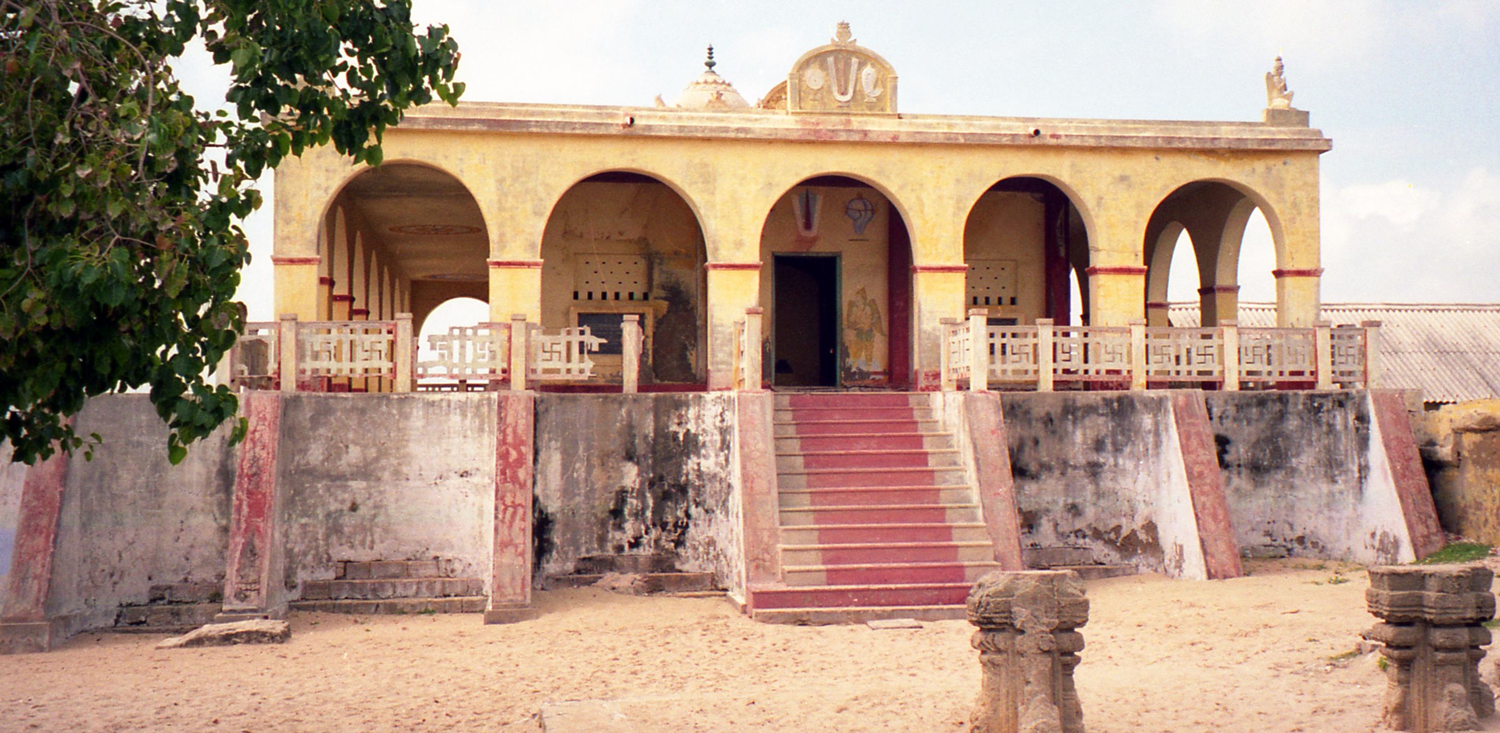
Forty years after the cyclone, the sea offered a strange memorial. Around the anniversary of the 1964 disaster, the waters around Dhanushkodi receded roughly 500 meters from the coastline, briefly exposing portions of the submerged town, the bones of buildings that had been underwater for four decades. Then, on 26 December 2004, the Indian Ocean tsunami struck the coast, and the waters returned violently. Today, visitors reach Dhanushkodi by a road completed in 2016, replacing the jeep tracks and footpaths that were the only access for decades. The ruins of the railway station, the church, and scattered walls stand among the dunes. The Kothandaramaswamy Temple, dedicated to Rama, survived the cyclone intact, the only structure that did. Pilgrims still visit it. Flamingos, terns, and reef herons wade in the shallows of the Gulf of Mannar Marine Sanctuary nearby. Sri Lanka is visible across the water, 15 miles away.
From the Air
Dhanushkodi is located at approximately 9.18N, 79.42E at the southeastern tip of Pamban Island. From altitude, the narrow sand spit extending into the Palk Strait is unmistakable, with the chain of Adam's Bridge shoals continuing toward Sri Lanka. Ruins of the town are visible as scattered fragments among sand dunes. Best viewed at 2,000-8,000 feet. Nearest airport is Madurai (VOMD), approximately 180 km northwest. The contrast between the Gulf of Mannar (south) and Palk Strait (north) is striking from above. The road from Rameswaram to Dhanushkodi is visible as a thin line along the sand spit.