Dharavi
Fifteen thousand factories fit inside 2.39 square kilometers. They produce leather goods, pottery, textiles, embroidery, recycled plastics, and ready-made garments, generating an estimated annual turnover exceeding one billion dollars. Dharavi is not what most people picture when they hear the word "slum." It is a self-organized industrial district squeezed between Mumbai's two main railway lines, home to roughly a million people who have built, without planning permission or government support, one of the most productive informal economies on Earth.
From Mangrove Swamp to Megacity
In the 18th century, Dharavi was an island of mangrove swamp, sparsely inhabited by Koli fishermen who called their settlement Koliwada. The transformation began during British colonial rule. In 1884, the colonial government started expelling polluting industries from the Bombay peninsula, and the tanneries came first -- the inaugural tannery relocated to Dharavi in 1887. Workers who processed leather, typically from the lowest Hindu castes and Muslim communities, followed. The Kumbhars, a Gujarati community of potters, arrived next, securing a 99-year land lease from the colonial government in 1895. Embroidery workers from Uttar Pradesh established the garment trade. As rural migrants poured into Bombay and its population passed one million, Dharavi absorbed wave after wave of arrivals. Each community carved out its own lane, its own trade, its own piece of the swamp.
A City Within a City
Dharavi sits between the Western and Central railway lines, adjacent to Mumbai Airport. To the west lie Mahim and Bandra; to the north, the Mithi River empties through Mahim Creek into the Arabian Sea. The settlement speaks Gujarati, Hindi, Marathi, Tamil, Telugu, and more -- a linguistic map of all the places people left behind. About 29 percent of residents are Muslim, roughly 6 percent Christian, with the rest predominantly Hindu alongside Buddhist and other minorities. Mosques, temples, and churches stand within blocks of each other, with Badi Masjid, a mosque, as the oldest religious structure in the neighborhood. With a literacy rate of 69 percent, Dharavi is the most literate informal settlement in India. On the western edge, the original Koli inhabitants still reside, their fishing heritage predating everything that grew up around them.
Living with What the City Provides
The cost of Dharavi's density is measured in public health. Water comes from public standpipes supplied by the municipal corporation, though much is lost to theft, illegal connections, and leakage. The plague of 1896 drove roughly half of Bombay's population to flee the city, and epidemics continued to devastate Dharavi for decades afterward -- dysentery, typhoid, cholera, leprosy, polio. A cholera outbreak in 1986 sent mostly children to hospitals in critical condition. In recent years, drug-resistant tuberculosis cases have been reported. Fires sweep through the narrow lanes periodically; a 2013 blaze destroyed many properties. Massive floods in 2005 caused deaths and extensive damage. When COVID-19 reached Dharavi in April 2020, the settlement's health workers mounted a containment response that drew international attention for its effectiveness under impossible conditions.
Redevelopment and the Question of Whose City
Plans to redevelop Dharavi have circulated since the 1950s, intensifying after 1997 with proposals modeled on Hong Kong's transformation of its informal settlements. The latest effort, backed by billionaire Gautam Adani's Adani Properties with investment estimated at 615 million dollars and a total project cost Mumbai authorities estimate at 2.4 billion dollars, represents the largest brownfield redevelopment project in India. Residents have pushed back. Many feel that 350 square feet of replacement housing per family is inadequate. Only families who lived in the area before 2000 qualify for resettlement, excluding newer arrivals. Small business owners fear their workshops in the informal sector will not survive relocation. A proposed Dharavi Community Land Trust would give residents a voice through community members, landowners, and neighborhood associations. What hangs in the balance is not just real estate but a question that defines Mumbai itself: who gets to stay in a city they helped build?
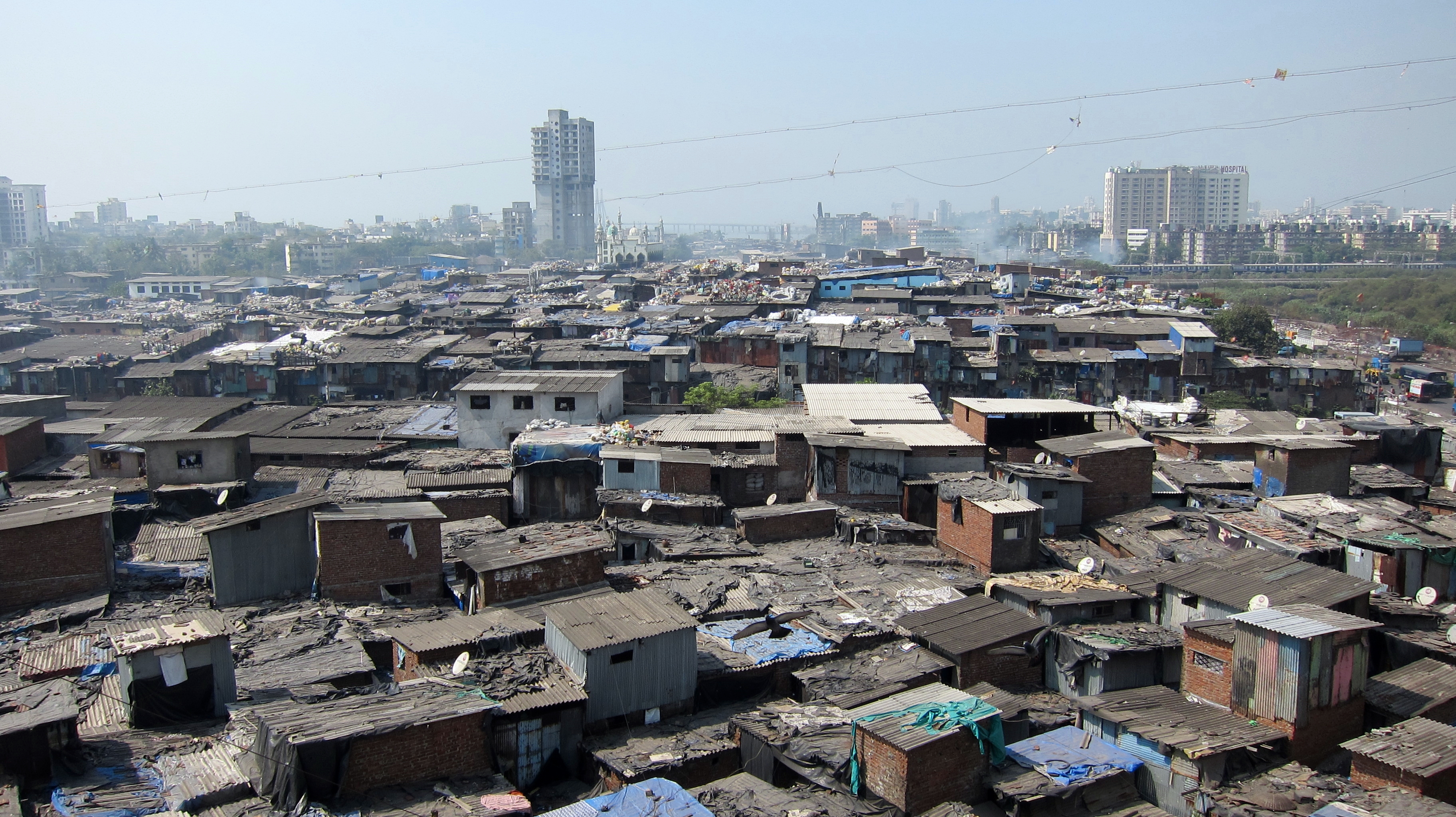
From the Air
Located at 19.044N, 72.856E in central Mumbai, Dharavi is visible from the air as a densely packed, low-rise area sandwiched between the parallel tracks of the Western and Central Railway lines, immediately south of Mumbai Airport. The contrast between Dharavi's tight urban fabric and the adjacent Bandra Kurla Complex business district -- one of Asia's most expensive commercial zones -- is striking from altitude. The Mithi River marks the northern boundary. Best viewed at 2,000-5,000 feet during approaches to or departures from Chhatrapati Shivaji Maharaj International Airport (VABB/BOM), which sits directly to the north.