Dharmarajika Stupa
Coins of the Indo-Greek king Zoilos II turned up beneath one of the smaller stupas ringing the main monument. That detail -- Greek currency buried under a Buddhist shrine in what is now Pakistan -- captures something essential about this place. The Dharmarajika Stupa sits three kilometers east of the Taxila Museum in Punjab, the largest stupa in a region where Alexander the Great once camped and Buddhist monks once studied logic and medicine. Emperor Ashoka ordered it built in the 3rd century BCE to house relics of the Buddha, and for the next seven hundred years, successive civilizations added to it without erasing what came before. The result is not a ruin so much as a palimpsest -- layers of devotion written in stone, one on top of another.
The Emperor's Monument
Ashoka, the Mauryan emperor who unified most of the Indian subcontinent in the 3rd century BCE, is credited with building the original stupa over relics of the Buddha. By some accounts, the Dharmarajika sits atop an even older structure. The name itself carries dual attribution: Dharmaraja -- "Lord of the Law" -- was a title for the Buddha, but it was also a title Ashoka adopted for himself. Whether the stupa honors the teacher or the emperor who spread his teachings, or both, depends on which scholarly tradition you follow. What is certain is that Indo-Greek coins found at the site date to the 2nd century BCE, confirming that a religious monument existed here within a century or two of Ashoka's reign. The stupa became the anchor for an entire monastic complex that grew around it over centuries, drawing monks and pilgrims along routes that would later become known as the Silk Road.
Three Kinds of Stone
Archaeologists have identified three distinct masonry techniques in the buildings surrounding the main stupa -- each corresponding to a different historical period and cultural influence. The layers are readable if you know what to look for: Mauryan-era construction sits alongside Kushan additions and later repairs. The stupa is circular in plan, the largest of all stupas in the Taxila region, and it was once surrounded by a passageway used for pradakshina -- the ritual practice of walking clockwise around a sacred object in meditation. Smaller votive stupas cluster around the main structure like satellites, built by donors and pilgrims over centuries. Eighteen reliquary vessels were recovered from these peripheral stupas, yielding an array of sacred objects including one that encased a cylindrical piece of gold. The architectural record here is not merely decorative; it is a timeline of who controlled this region and what they believed.
Monks on the Frontier
The monastic complex that grew around the Dharmarajika was substantial. Early cells were built as rows of rooms with verandahs -- practical living quarters for monks who devoted their days to study, meditation, and the maintenance of the stupa. Taxila was no backwater. It was one of the ancient world's great centers of learning, a crossroads where Gandharan, Persian, Greek, and Central Asian cultures intersected. Students came here to study subjects ranging from medicine to archery. The Buddhist monasteries at Taxila were part of this intellectual ecosystem, and the Dharmarajika complex was its spiritual heart. The nearby ancient city of Sirkap, also part of the Ruins of Taxila, was built by Indo-Greek rulers in the 2nd century BCE -- a planned city with a Hippodamian grid layout overlaid on South Asian religious traditions. That Greek urban planners and Buddhist monks occupied the same valley at the same time is one of history's more underappreciated cultural encounters.
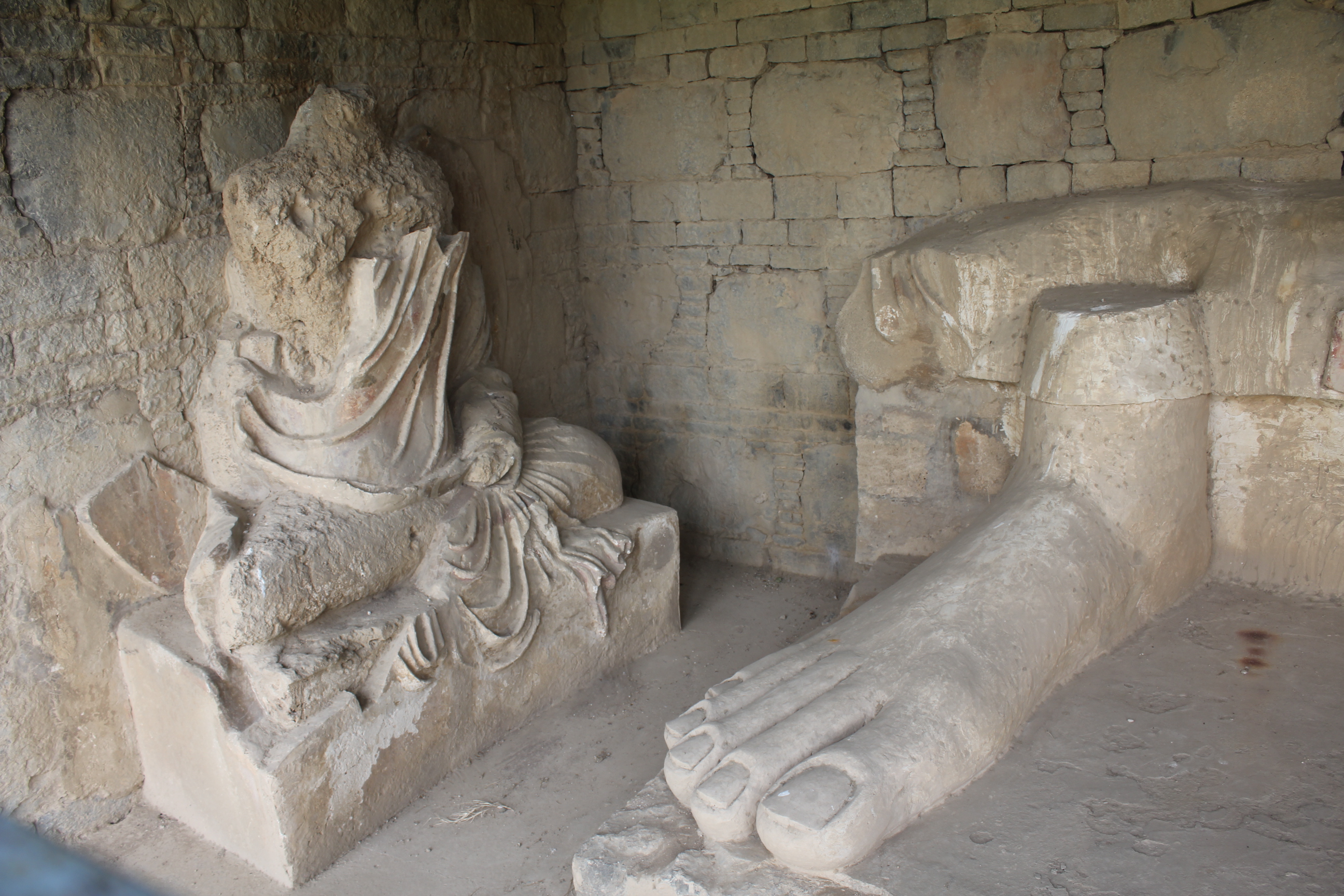
What Was Lost, What Remains
Sir John Marshall, the British archaeologist who directed excavations at Taxila in the early 20th century, found that much of the stupa's precious contents had been looted long before he arrived. The reliquary vessels that survived were remarkable -- but they represented a fraction of what had once been housed here. Stucco heads and Indo-Corinthian pillars recovered from the site reveal a sculptural tradition that fused Hellenistic realism with Buddhist iconography, producing faces with Greek features framed by Indian lotus motifs. These artifacts are now scattered across museums. The stupa itself, popularly known as Chir Tope -- "Scarred Hill" -- still rises from the Pothohar Plateau, its scars earned over two millennia of weather, war, and treasure hunters. The Ruins of Taxila were inscribed as a UNESCO World Heritage Site in 1980, recognizing not just the Dharmarajika but the entire archaeological landscape: Bhir Mound, Sirkap, Sirsukh, Jaulian, Mohra Muradu, and the connecting tissue of roads and water systems that once linked them.
A Living Crossroads
Today the Dharmarajika Stupa lies along PMO Colony Road, northeast of Taxila Cantonment, about three kilometers from the Taxila Museum where many of its recovered artifacts are displayed. The setting is quiet -- green fields and low hills, the Margalla range visible in the distance. It takes imagination to reconstruct the bustle that once filled this valley: caravans arriving from Central Asia, monks debating in Pali and Sanskrit, Greek merchants haggling in the marketplace at Sirkap. But the physical evidence is still here, embedded in stone. The three types of masonry, the Greek coins beneath Buddhist shrines, the Indo-Corinthian columns -- all of it testifies to a place where civilizations did not merely pass through but stopped, built, and left something behind. The Dharmarajika Stupa is the oldest surviving anchor of that layered history, a monument to the idea that sacred ground accumulates meaning the way stone accumulates weathering: slowly, irreversibly, and from every direction at once.
From the Air
The Dharmarajika Stupa (33.74N, 72.84E) is located near Taxila in Pakistan's Punjab province, approximately 35km northwest of Islamabad. The site sits in the Pothohar Plateau, a relatively flat landscape with the Margalla Hills visible to the east. Nearest airport: Islamabad International Airport (OPIS/ISB), approximately 40km east-northeast. The archaeological zone of Taxila is spread across several square kilometers of low terrain. From altitude, the stupa site appears as cleared archaeological grounds amid green agricultural land. The Grand Trunk Road passes nearby, a major east-west artery visible from the air.