Dhofar
For two thousand years, the most valuable commodity in the ancient world was not gold, silk, or spices. It was tree resin. Frankincense, the aromatic sap of the Boswellia sacra tree, was burned in temples from Rome to Beijing, and the trees that produced the finest grade grew in only one place: the limestone slopes of Dhofar, in what is now southern Oman. The gnarled Boswellia trees still cling to those same hillsides. But Dhofar's deeper peculiarity is climatic. Every summer, the khareef monsoon rolls in from the Indian Ocean and transforms this corner of Arabia into something transplanted from the tropics. Waterfalls cascade through green wadis. Fog drapes the mountains. Drive thirty kilometers inland, past the mountain barrier, and you are back in one of the driest landscapes on Earth: the Rub al Khali, the Empty Quarter, a sea of sand stretching to the horizon.
The Frankincense Coast
The ancient port of Sumhuram, near modern Taqah, was once the hub of a trade network stretching from the Mediterranean to India. Roman historian Pliny the Elder described frankincense as more valuable than gold, and the resin's journey from Dhofar to the temples of the ancient world followed overland routes that took months to traverse. The highest grade, known as Hojari, comes from the eastern mountains around Jabal Samhan, where limestone soil, altitude, and monsoon moisture combine to produce resin of exceptional clarity. The lightest-colored pieces command the highest prices. You can still buy Hojari in the souqs of Salalah, graded by color from amber to near-white, alongside hand-crafted clay incense burners made from local Dhofari earth. The trade has shrunk from its ancient scale, but it has never stopped.
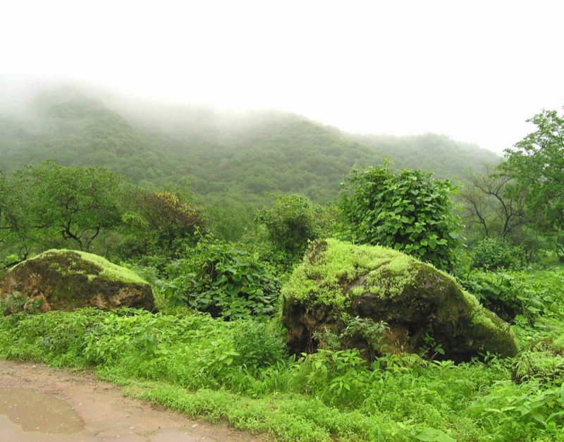
When the Desert Turns Green
The khareef defies everything you expect from Arabia. Between June and September, the southwest monsoon sweeps moisture off the Indian Ocean against the Dhofar Mountains, which run parallel to the coast and rise above 1,800 meters. The mountains wring the clouds dry, turning coastal slopes into a green paradise of cascading wadis, wildflowers, and grazing herds. Temperatures drop to the low twenties Celsius while the rest of the peninsula bakes above forty. Visitors from the Gulf states flood into Salalah for the annual Salalah Festival, escaping heat that makes outdoor life elsewhere punishing. But the monsoon's generosity has strict boundaries. The rains do not cross the ridge. Travel a short distance northwest and the landscape reverts to bare rock and sand, then gives way to the Empty Quarter, where Wilfred Thesiger made his famous crossings in the late 1940s with local Bedu tribesmen. Lush green on one side, lifeless desert on the other.
A Mosaic of Peoples
Dhofar's population is not one community but a mosaic shaped by geography. The Badawi, the nomadic Bedu, roam the interior deserts with camels and goats. The Jebali inhabit the coastal ranges, herding cattle on slopes their ancestors have worked for generations. Their languages, collectively called Jibbali, are not dialects of Arabic but members of the Modern South Arabian family, closer to the Semitic languages of Ethiopia and Eritrea than to the Arabic of Muscat. Along the coast live the Hadhari, the settled population, and Omanis of African descent form another thread, many tracing roots to Zanzibar during the centuries when Oman's maritime empire stretched across the Indian Ocean. Dhofar's relationship with northern Oman has not always been harmonious. The Dhofar Rebellion, from 1962 to 1976, pitted separatist and Marxist insurgents against the Sultanate. The conflict ended only after Sultan Qaboos, who came to power in 1970, undertook sweeping reforms that modernized the region.
Sinkholes, Leopards, and the Road West
The geology hides spectacles underground. Tawi Atayr, the Well of Birds, is a sinkhole 211 meters deep that once served as a water source for local tribes. Nearby, Taiq Cave plunges to an average depth of 800 meters, part of a vast karst network only partially explored. In the remote eastern reaches of Jabal Samhan lies a nature reserve closed to the public, the last refuge of the Arabian leopard in the wild. West from Salalah, Highway 47 leads toward the Yemeni border through scenery that escalates steadily. At Mughsayl, blowholes shoot jets of seawater through cavern openings during high tide. Beyond the beach, the road climbs 1,000 meters in eight switchbacks, opening views into Wadi Aful. The plateau above stretches toward Rakhyut and Dhalkut, the last settlement before the closed Yemeni border, where a half-buried shipwreck rusts on the beach and an enormous fig tree known as the Tree from Far Away stands three kilometers to the east.
Edge of the Known World
East of Mirbat, the coast road to Hasik hugs cliffs above a blue sea, passing fishing villages where the ancient frankincense trade once loaded ships bound for distant ports. Sea turtles surface offshore. Migratory birds pause along the shore in spring and autumn. The diving season runs from October through May, after the monsoon calms, with sites off Mirbat and near the remote Khuriya Muriya Islands. On land, three venomous snakes share the terrain: the Arabian cobra in the mountains, the puff adder in dry wadis, and the saw-scaled viper near water. Dhofar rewards those willing to travel slowly and carry enough water. There are stretches where no restaurant, no petrol station, and no settlement interrupts the landscape for hours. The region exists at the edge of something, where the Arabian Peninsula meets the Indian Ocean, where desert meets monsoon, and where the ancient world's most precious commodity still bleeds from the bark of living trees.
From the Air
Dhofar occupies the southern coast of Oman, centered around 18.00N, 54.00E. The region stretches from the Yemeni border in the west to well past Mirbat in the east. From altitude, the Dhofar Mountains are a clear east-west ridge separating the green coastal strip from the tan emptiness of the Rub al Khali to the north. During the khareef (June-September), the contrast is dramatic: green slopes on the ocean side, bare desert on the inland side. Salalah Airport (OOSA) is the primary airport, with the city visible as a coastal settlement backed by mountains. Thumrait Air Base (OOTH) lies about 80 km to the north on the desert plateau. Best viewed at 5,000-10,000 feet AGL to appreciate the mountain-desert contrast.