Dieng Plateau: Where the Gods Reside Above the Clouds
The name gives it away. In Old Javanese, "di" means place and "hyang" means gods or ancestors. Dieng - Dihyang - is the place where the gods reside. At 2,100 meters above sea level, Java's highest plateau earned the title honestly. Clouds roll through the caldera like slow-moving rivers, swallowing entire hillsides and leaving farmers to work their potato fields in a pale gray world. When the mist clears, the views stretch across a volcanic landscape so fertile and so dangerous that people have been drawn to it - and driven from it - for over a thousand years.
The Land Above the Clouds
The Dieng Plateau fills the floor of a caldera complex on the Dieng Volcanic Complex, stretching roughly 6 kilometers north to south and 14 kilometers west to east. It straddles two regencies - Banjarnegara to the west (Dieng Kulon) and Wonosobo to the east (Dieng Wetan) - in the province of Central Java. Mountains ring the plateau on all sides. To the west lies the Serayu Plain, to the east the Kedu Plain, and to the north the coastal lowlands of Pekalongan and Batang.
The altitude creates something rare in tropical Indonesia: a subtropical climate. Frost arrives in the dry season, killing potato crops and coating the highlands in a crystalline layer that draws tourists with cameras. The plateau is popularly called "the land above the clouds," and the description is literal. Morning fog can reduce visibility to meters, and the temperature drops low enough to shock visitors arriving from the sweltering lowlands below.
Fire Beneath the Fields
The volcanic forces that carved the caldera did not go quiet. Beneath the potato fields and temple ruins, the earth stores enormous reserves of geothermal energy. The Dutch East Indies government began investigating Dieng's geothermal potential as early as 1918, and in 1964 Indonesia designated the plateau as a high-priority geothermal resource. Today, wells drilled to depths between 1,500 and 2,000 meters tap steam reserves estimated at around 400 megawatts.
Sulphur-colored lakes dot the landscape, fed by volcanic gases seeping through the rock. The smell of sulfur hangs in certain valleys. These are not gentle reminders of geological activity - in 1979, a phreatic eruption at Sinila crater released poisonous gases that killed 149 people in surrounding villages. The plateau's beauty comes with a standing threat, and the people who farm here live with that knowledge as a daily fact.
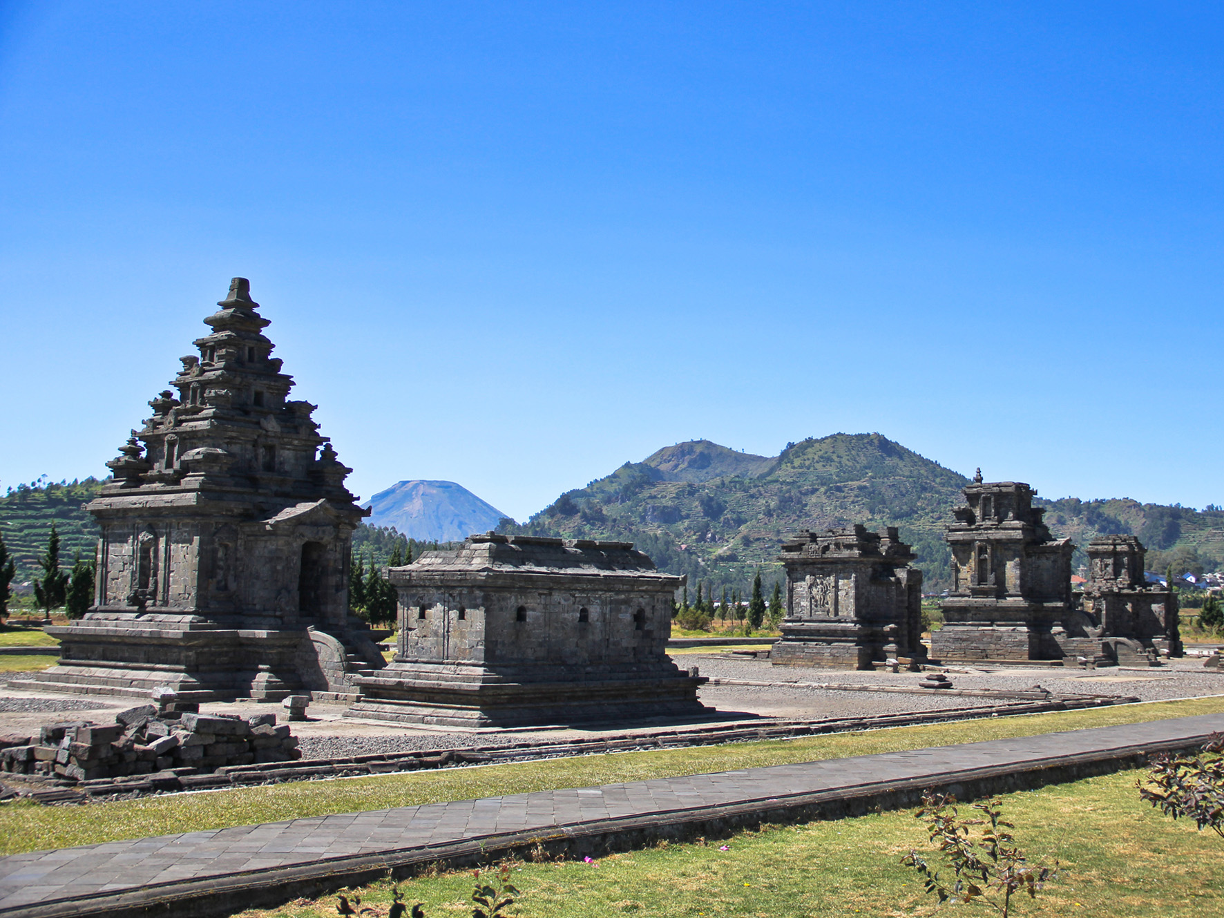
Temples in the Mist
Sometime in the 7th or 8th century, the Kalingga Kingdom chose this remote, cloud-wrapped plateau as a site for Hindu worship. The temples they built - small stone shrines dedicated to Shiva - are among the oldest surviving religious structures on Java. Originally, as many as 400 temples may have stood here. Eight survive.
They are clustered in three groups: the Arjuna, Dwarawati, and Gatotkaca complexes, plus the solitary Bima temple perched on its own hill. Local Javanese named them after characters from the Mahabharata epic, since the original names were lost centuries ago. The Kailasa museum nearby houses sculptures removed from the temple sites - stone faces and figures that once watched over a plateau the ancient Javanese considered sacred ground, a high place fit for the divine.
Between Sacred and Practical
Modern Dieng is a place of layered purposes. The sacred geography that drew Hindu temple builders in the 7th century now coexists with commercial potato farming, geothermal power generation, and a growing tourism industry. Farmers tend terraced plots between sulfurous vents. Power lines run past temple ruins. Tour buses navigate narrow roads carved into volcanic hillsides.
Every August, the Dieng Culture Festival draws thousands of visitors for traditional Javanese performances, the ritual cutting of children's dreadlocks (a local tradition believed to ward off illness), and gatherings at the ancient temple sites. The festival is a reminder that Dieng's identity as a spiritual place did not end with the Hindu period. It adapted, absorbed Islam and Javanese folk traditions, and persisted - much like the plateau itself, which has survived eruptions, draining, reforestation, and agricultural conversion while remaining, stubbornly, the land above the clouds.
From the Air
Dieng Plateau (7.21S, 109.86E) is located in Central Java, Indonesia, at an elevation of approximately 2,100 meters ASL inside a volcanic caldera. The nearest major airport is Ahmad Yani International Airport (WAHS) in Semarang, roughly 120km to the northeast. Adisucipto International Airport (WARJ) in Yogyakarta is about 110km to the southeast. From the air, the plateau is identifiable as a flat highland surrounded by a ring of volcanic peaks, often obscured by cloud cover. Sulphur-colored volcanic lakes and geothermal steam vents are visible in clear conditions. Best approached from the east or south at 8,000-10,000 feet MSL. Expect frequent low clouds and reduced visibility, especially in the morning.