Dingle Peninsula
The village of Dun Chaoin sits at the western edge of the Dingle Peninsula, facing nothing but three thousand miles of Atlantic Ocean. Locals joke that it is "the next parish to America." The humour masks something real: this is the westernmost inhabited point of mainland Ireland, where Europe ends in sea cliffs and wind-bitten grass. The Dingle Peninsula -- Corca Dhuibhne in Irish, named for the ancient people who held these lands in the Middle Ages -- is a place where geography enforced isolation and isolation preserved what the rest of Ireland was losing: the Irish language, oral storytelling traditions, and a density of ancient monuments that turns every hillside into an open-air museum.
Spine of Stone
The peninsula exists because of sandstone. A band of hard rock forms the Slieve Mish mountains at its eastern neck and the Brandon Group to the west, creating a mountainous spine that shelters the southern coast from the worst of the Atlantic weather. Mount Brandon rises to 952 metres, the highest peak in Ireland outside MacGillycuddy's Reeks, offering views across the peninsula and north into Kerry. Conor Pass, the highest mountain pass in Ireland, threads between Dingle town and Brandon Bay through a narrow road that clings to cliff faces and skirts dark corrie lakes. Off the western tip, the Blasket Islands sit in the ocean like the last punctuation mark of a sentence that Europe began thousands of kilometres to the east. They have been uninhabited since the 1950s, when the remaining islanders were evacuated.
Voices from the Edge
The western end of the peninsula is a Gaeltacht, an Irish-speaking area, and one of the most culturally productive in the country. This stretch of coastline produced Peig Sayers, the Great Blasket storyteller whose autobiography became a touchstone of modern Irish literature. Piaras Feiriteir, the seventeenth-century poet and rebel, lived and fought here. Novelist Flann O'Brien admired the Gaeltacht memoir tradition enough to satirise it mercilessly in An Beal Bocht (The Poor Mouth), set in a fictional, desperately poor, perpetually raining Irish-speaking village that readers recognised all too well. Sean-nos singer Muireann Nic Amhlaoibh grew up in Dun Chaoin, carrying forward a tradition of unaccompanied singing that stretches back centuries.
Written in Stone
The peninsula is dense with prehistoric and early medieval remains. The Gallarus Oratory, near Ballyferriter, is a perfectly preserved early Christian church built entirely of dry stone, its walls curving inward to form a corbelled roof that has kept out rain for over a thousand years. Ogham stones inscribed with Ireland's earliest writing system dot monastic settlements at Kilmalkedar and the excavated site of Riasc. In April 2021, an Irish farmer stumbled onto an untouched Bronze Age tomb -- skeletal remains, fragments of human bone, and a semicircular stone slab in an underground passage. Archaeologists from the National Monuments Service described it as a chambered tomb from the prehistoric period, "a significant marker on the landscape" undisturbed for nearly four thousand years.
Set Pieces
Hollywood discovered the Dingle Peninsula decades ago and keeps returning. David Lean filmed Ryan's Daughter here in 1970, using Coumeenole Beach and Slea Head as backdrop for a story set in 1917, in the turbulent year after the Easter Rising. Ron Howard brought Far and Away in 1992. Most recently, crews built eight replica clochans -- the ancient dry-stone beehive huts -- at Ceann Sibéal (Sybil Head) near Ballyferriter for Star Wars: The Last Jedi, mimicking the real structures on Skellig Michael offshore. The peninsula also holds grimmer historical markers: near the village of Brandon, the hillside called Slieveglass was the site of Ireland's first fatal airliner accident, when a BOAC Sunderland flying boat crashed in fog on 28 July 1943 while descending toward Foynes, killing 10 of the 25 aboard.
Where the Road Ends
Beyond Dingle town, the road narrows and the landscape opens. At Dunmore Head, the westernmost point of mainland Ireland, the cliffs fall away to a sea that stretches unbroken to Newfoundland. The wreck of the MV Ranga, a Spanish cargo vessel that ran aground in 1982, rusts on the coast as a reminder that these waters have always been dangerous. Rahinnane Castle, a fifteenth-century tower built atop a medieval ringfort, watches over the approach from an older era. Gallaunmore, a standing stone and National Monument, marks time in a way that human calendars cannot. The Dingle Peninsula is where Ireland runs out of land -- and where, for precisely that reason, its oldest traditions found a place to hold on.
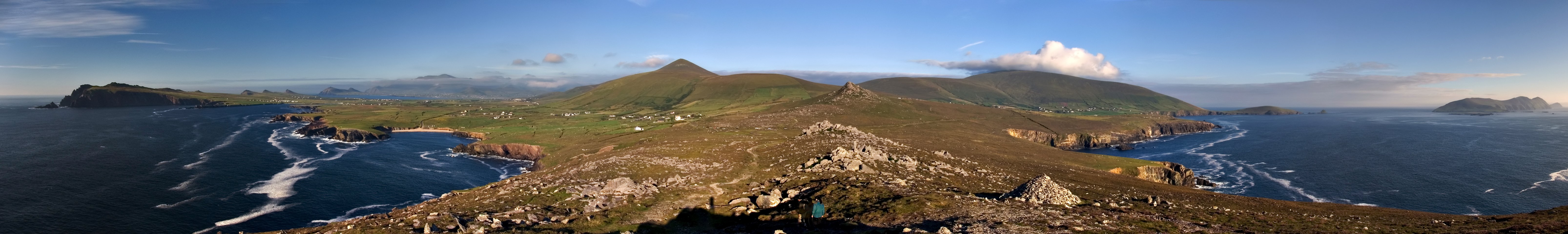
From the Air
The Dingle Peninsula is located at approximately 52.19N, 10.08W, extending westward into the Atlantic from County Kerry. From the air, the peninsula is unmistakable: a mountainous finger of land bounded by Dingle Bay to the south and Brandon Bay to the north. Mount Brandon (952m) is the dominant peak. The Blasket Islands are visible off the western tip. Kerry Airport (EIKY) is approximately 30 km to the southeast. Shannon Airport (EINN) is 80 km to the north. Best viewed at 3,000-6,000 feet for the full peninsula panorama.