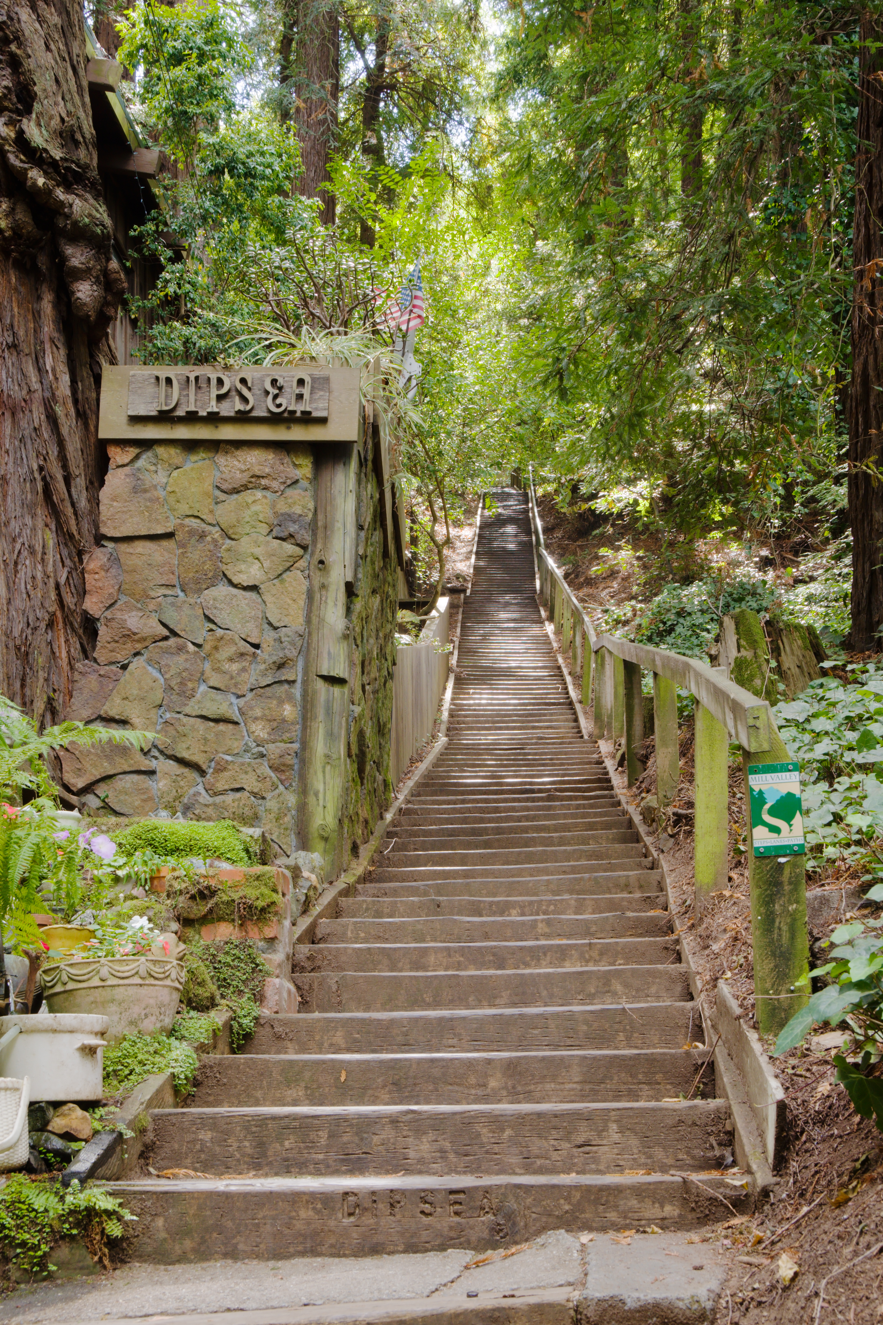
Dipsea Trail
The Dipsea Race starts with stairs. Six hundred and eighty-eight of them, climbing straight up from the town of Mill Valley into the coastal ridges of Marin County. Runners have been grinding up these steps since 1905, making the Dipsea the oldest trail race in America -- older than the Boston Marathon's current course, older than any organized footrace west of the Mississippi that is still being run. The 7.5-mile trail crests a ridge above Muir Woods and drops down through coastal scrub to the Pacific Ocean at Stinson Beach, and in over a century of competition, nobody has found an easy way to do it.
The Race That Started Everything
The first Dipsea Race was run in 1905, and it set a precedent that rippled across the Bay Area for decades. The trail was deemed significant enough to be listed on the National Register of Historic Places in 2010, recognized as "the founding footrace that laid the groundwork for a long Bay Area tradition that linked community with fitness and civic wellbeing." After the 1906 earthquake, city leaders seeking to boost morale created San Francisco's Cross City Race in 1912, modeled explicitly on the Dipsea -- runners started at the bay side of the city and ran over hilly streets to the Pacific Ocean. That race evolved into Bay to Breakers, now one of the largest footraces in the world with over 65,000 participants. The Italian athletic club Unione Sportiva Italiana sponsored the Statuto Race in 1919, energizing North Beach's immigrant community through annual competition on city streets.
The Trail Itself
The Dipsea Trail runs approximately 7.5 miles from Mill Valley to Stinson Beach, crossing land managed by a patchwork of owners: the National Park Service, the State of California, Marin County, the City of Mill Valley, and the Flying Y Homeowners Association. The route climbs steeply from downtown Mill Valley through redwood groves and open grassland, crests a ridge with views of the Pacific, then descends through coastal hills to the beach. Runners in the race are not restricted to a single path -- experienced competitors have practiced alternate routes through less-traveled terrain near the finish, shaving seconds by knowing which deer trail cuts a switchback. But for most of the route, the main path is unmistakable, defined by the stairways at the start and the packed earth of a trail worn by more than a century of feet.
A Democratic Tradition
What makes the Dipsea unique among American races is its handicap system. Runners are assigned time advantages based on age and gender, meaning a twelve-year-old girl or a seventy-year-old man starts well ahead of elite runners in their twenties. The fastest runner does not always win. This structure reflects the race's founding philosophy: that community participation matters more than pure athletic performance. The Dipsea has inspired similar handicapped trail races throughout the Bay Area, including the Dick Houston Memorial Woodminster Cross Country Race in the Oakland hills, which began in 1965, and the Kenwood Foot Race in Sonoma County, held every Fourth of July since 1971. These events share the Dipsea's emphasis on challenging terrain, local tradition, and civic spirit over prize money.
Over the Ridge and Down
The trail's popularity extends well beyond race day. Hikers walk the Dipsea year-round, often combining it with side trips through Muir Woods or Mount Tamalpais State Park. AllTrails lists a 9.7-mile out-and-back version. In winter, the coastal hills are emerald green and the creeks run fast. By summer, the grass turns gold and the fog rolls in from the Pacific, sometimes so thick that runners vanish into it cresting the ridge. The Dipsea Trail is not the longest trail in Marin County, nor the steepest, nor the most remote. But it is the one that carries the most history in its switchbacks. Every runner who climbs those opening stairs joins a line that stretches back to 1905, when someone looked at the ridge between Mill Valley and the ocean and decided the fastest way over it was a race worth running.
From the Air
The Dipsea Trail runs from Mill Valley (37.91N, 122.55W) to Stinson Beach (37.90N, 122.64W) in Marin County, crossing ridges visible from the air as a line between the bay and the Pacific. Best viewed from 2,000-4,000 feet AGL. The trail traverses Mount Tamalpais State Park and Golden Gate National Recreation Area. Nearby airports: KOAK (Oakland International, 18nm E), KSFO (San Francisco International, 18nm S). The Marin Headlands and Muir Woods are prominent visual references.