Diu Fortress
The fortress came into being because a sultan needed help and a colonial power needed a foothold. In 1535, when Mughal Emperor Humayun threatened to annex Gujarat, Sultan Bahadur Shah made what must have seemed like a reasonable bargain: he allowed the Portuguese to build a fort on the eastern tip of Diu island in exchange for military protection. Within two years, the sultan was dead -- killed in a fracas with the Portuguese in Diu's own harbor -- and the fortress his desperation had permitted became the cornerstone of Portuguese power on India's western coast for the next 426 years.
Before the Portuguese Stones
Long before European ships appeared on the horizon, Diu island changed hands among Indian dynasties. The Chavda Rajputs held it in the 9th century, followed by the Vaghela dynasty, before the Gujarat Sultanate absorbed the island into its territories. The location explains the appeal: Diu sits at the mouth of the Gulf of Cambay, commanding the sea routes to Cambay, Bharuch, and Surat -- the trading ports that made Gujarat one of the wealthiest regions in the Indian Ocean world. Whoever controlled this narrow island controlled access to Gujarat's commerce. The Portuguese understood this geography immediately and had sought permission to build here for years before Bahadur Shah's crisis with the Mughals finally opened the door.
A Fortress Built by Betrayal
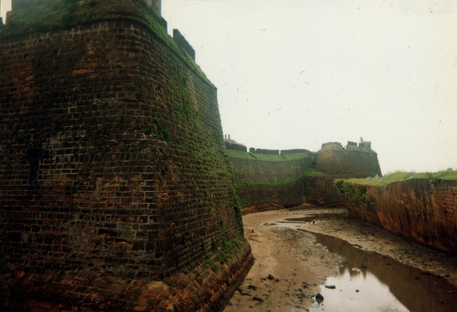
Construction began in 1535, and the Portuguese strengthened the fortifications steadily over the following decade, completing the work by 1546. The design exploited the island's natural advantages. The outer wall followed the coastline, with the sea lapping against three sides. An inner wall bristled with bastions and mounted guns. Between the two ran a double moat -- the outer one tidal, flooding with the sea -- cut through the island's sandstone bedrock. Three gates controlled access, and a jetty on the northwestern side served both military and commercial traffic. In the deep-water channel beside the fort walls, the Portuguese strengthened an existing bastion originally built by the sultan, turning their ally's own defensive work into a projection of their own power. The arrangement that created the fortress collapsed almost immediately. Sultan Bahadur Shah, regretting his concession, grew hostile. In 1537, he was killed during a confrontation with the Portuguese in Diu harbor, triggering a succession crisis in the Gujarat Sultanate that left the Portuguese in an awkward position -- resolved only by a hasty truce with the new sultan.
Centuries of Siege and Survival
The fortress earned its reputation in blood. Ottoman and Gujarati forces besieged it in 1538 and again in 1546, and the Portuguese held both times against vastly superior numbers. The fortress became proof that a well-designed fortification at a strategic chokepoint could project power across an ocean. But it was not invulnerable. In 1670, raiders from Muscat pillaged both the fort and the town, demonstrating that even the most formidable walls could not guarantee safety from every threat. The Portuguese presence endured through the rise and fall of the Mughal Empire, through the establishment of British India, and into the era of Indian independence. It was not until December 19, 1961, that India launched Operation Vijay to end Portuguese rule in Goa, Daman, and Diu. Indian soldiers who died in the capture of Diu are commemorated at the Martyrs Memorial near the Collectorate office -- a monument that marks the end of European colonial fortification on Indian soil.
Stone, Sea, and Recognition
Today the fortress is the defining landmark of Diu. The moat cut through living sandstone, the gun positions on the inner bastions, the massive outer walls tracing the coastline -- all survive as testimony to 16th-century military engineering adapted to a specific and unforgiving seascape. The Praca de Diu, as the Portuguese called the fortress-castle complex, was recognized as one of the Seven Wonders of Portuguese Origin in the World, placing it alongside monuments in Brazil, Morocco, and Mozambique. Walking through it, the layers of occupation are legible: the sultan's bastion reinforced by Portuguese engineers, the churches built within the walls, the relics of petrified wood now displayed in the Diu Museum. Nearby, St. Paul's Church stands as another reminder that this tiny island was, for centuries, a node in a trading network that stretched from Lisbon to Macau.
From the Air
Diu Fortress sits at 20.715N, 70.996E on the eastern tip of Diu island, at the mouth of the Gulf of Cambay off Gujarat's southern coast. The fortress is clearly visible from the air, skirting the sea on three sides with the double moat and inner/outer walls forming a distinctive pattern. Nearest airport: Diu Airport (DIU/VADU). The channel separating the island from the mainland, the jetty on the northwest side, and the bastions are identifiable from 3,000-5,000 feet. The Arabian Sea stretches west; Gujarat's coast lies to the north and east.