Dolmen of Menga
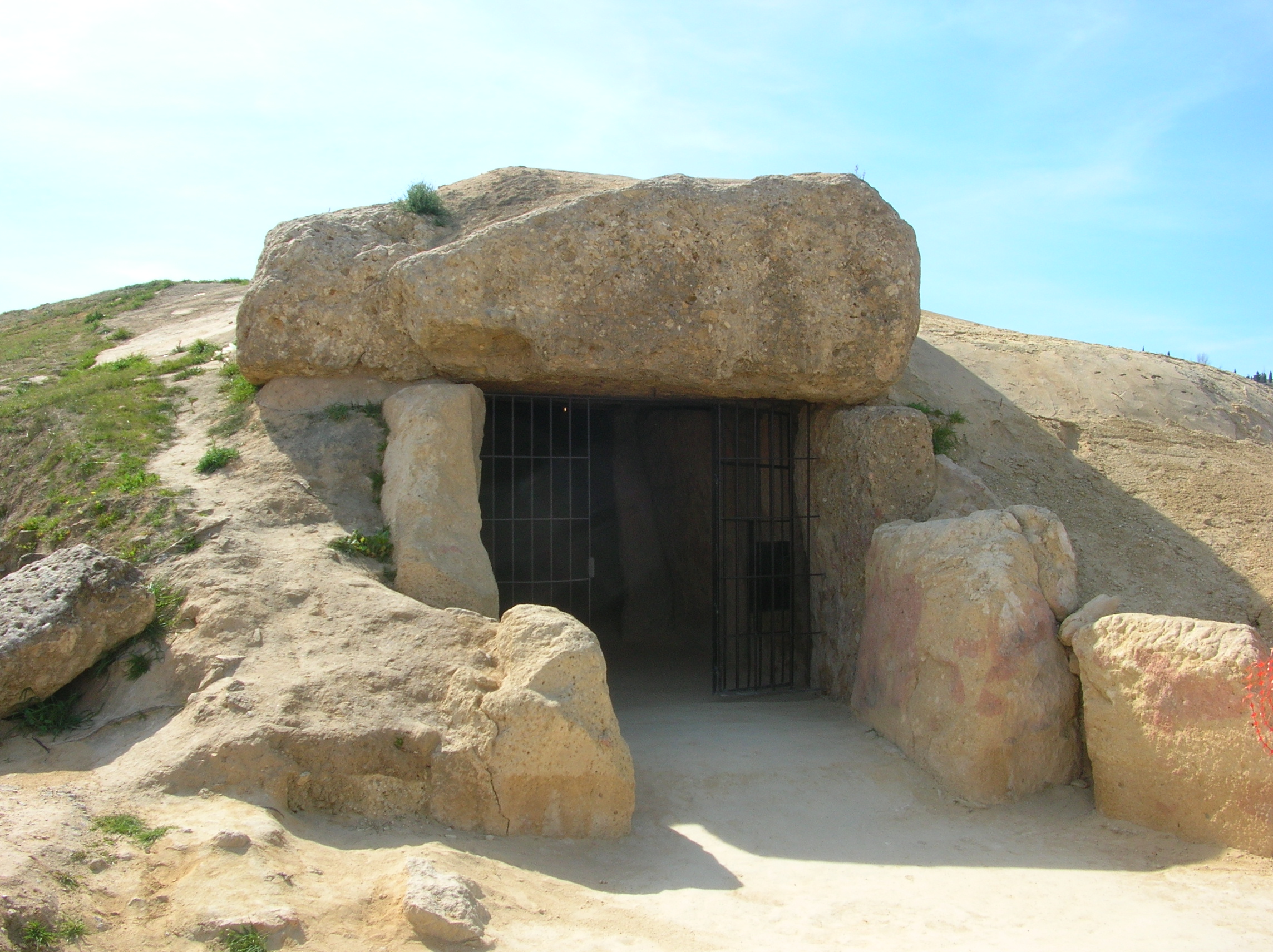
Thirty-two megaliths, the heaviest weighing 180 tonnes. A chamber 27.5 meters long, 6 meters wide, and 3.5 meters high, buried under an earthen mound that has kept its shape for nearly six thousand years. When archaeologists opened the Dolmen of Menga in the 19th century, they found the skeletons of several hundred people inside, the accumulated dead of a ruling elite who had commanded the labor of their community to build one of the largest megalithic burial structures in all of Europe.
Aligned to the Mountain
Most Neolithic tombs in Europe orient themselves toward the sunrise, typically the summer or winter solstice. The Dolmen of Menga does not. Its central axis points northeast, toward a rock shelter called the Abrigo de Matacabras at the foot of the Pena de los Enamorados, a mountain whose profile resembles a reclining human face. This orientation is unique among European tombs of its cultural context. In 2018, the ATLAS research group from the University of Seville analyzed the schematic cave paintings inside the Abrigo de Matacabras and confirmed their Neolithic date, placing them at the beginning of the 4th millennium BC. The visual and symbolic link between the dolmen and the rock shelter establishes a landscape relationship that may be without parallel in European prehistory. The builders were not just burying their dead. They were pointing them toward something.
Engineering Before the Wheel
The construction of the Dolmen of Menga around 3750-3650 BCE represents a staggering feat of organization and labor. The 32 megaliths that form the chamber walls and ceiling had to be quarried, transported, and lifted into position without metal tools, wheels, or draft animals. The largest capstone alone weighs approximately 180 tonnes. After the stone chamber and its entry corridor were completed, the entire structure was buried under earth to create the mound visible today. The engineering required a society capable of marshaling hundreds of workers, feeding them, and coordinating their efforts over what must have been months or years. The dolmen sits just 70 meters from the Dolmen de Viera and about 4 kilometers from the Tholos de El Romeral, a subterranean structure of different design, suggesting that this landscape served as a ceremonial and funerary complex across centuries.
A World Heritage Landscape
In 2016, the dolmens of Menga, Viera, and El Romeral were inscribed together as a UNESCO World Heritage Site under the name Antequera Dolmens Site. The designation recognized not just the individual monuments but the landscape they inhabit, including the Pena de los Enamorados and the karst formations of nearby El Torcal. Together, they form a cultural landscape where prehistoric communities deliberately placed their most important structures in relationship to natural features they considered sacred. The dolmen complex sits near the town of Antequera in the province of Malaga, at a crossroads that has been geographically strategic since before recorded history. The people who built the Dolmen of Menga chose this spot not by accident but by design, orienting their dead toward a mountain that their descendants would remember for thousands of years.
The Dead and Their Keepers
Walking into the Dolmen of Menga is walking into a space that was designed to impress. The entrance opens into a corridor that narrows slightly as it leads to the main chamber, where the massive capstones overhead create a sense of weight that is physical, not just psychological. The chamber probably served as a communal tomb for ruling families over generations, with the skeletons of several hundred individuals accumulating over centuries of use. A well at the back of the chamber cuts into the bedrock, its purpose still debated. The dolmen's darkness is complete beyond the entrance, the kind of darkness that amplifies sound and erases the boundaries of the room. Whatever rituals took place here, they happened in the presence of the accumulated dead, under stones that the builders knew would outlast everything else they would ever make. They were right.
From the Air
Located at 37.02N, 4.55W near Antequera in the province of Malaga. The earthen mound of the dolmen is visible from low altitude as a rounded hill near the edge of town. The distinctive profile of the Pena de los Enamorados mountain is visible to the northeast, and the karst formations of El Torcal are to the south. Nearest airport: Malaga-Costa del Sol (LEMG), approximately 45 km south. Antequera sits at the junction of major roads connecting Malaga, Granada, Cordoba, and Seville.