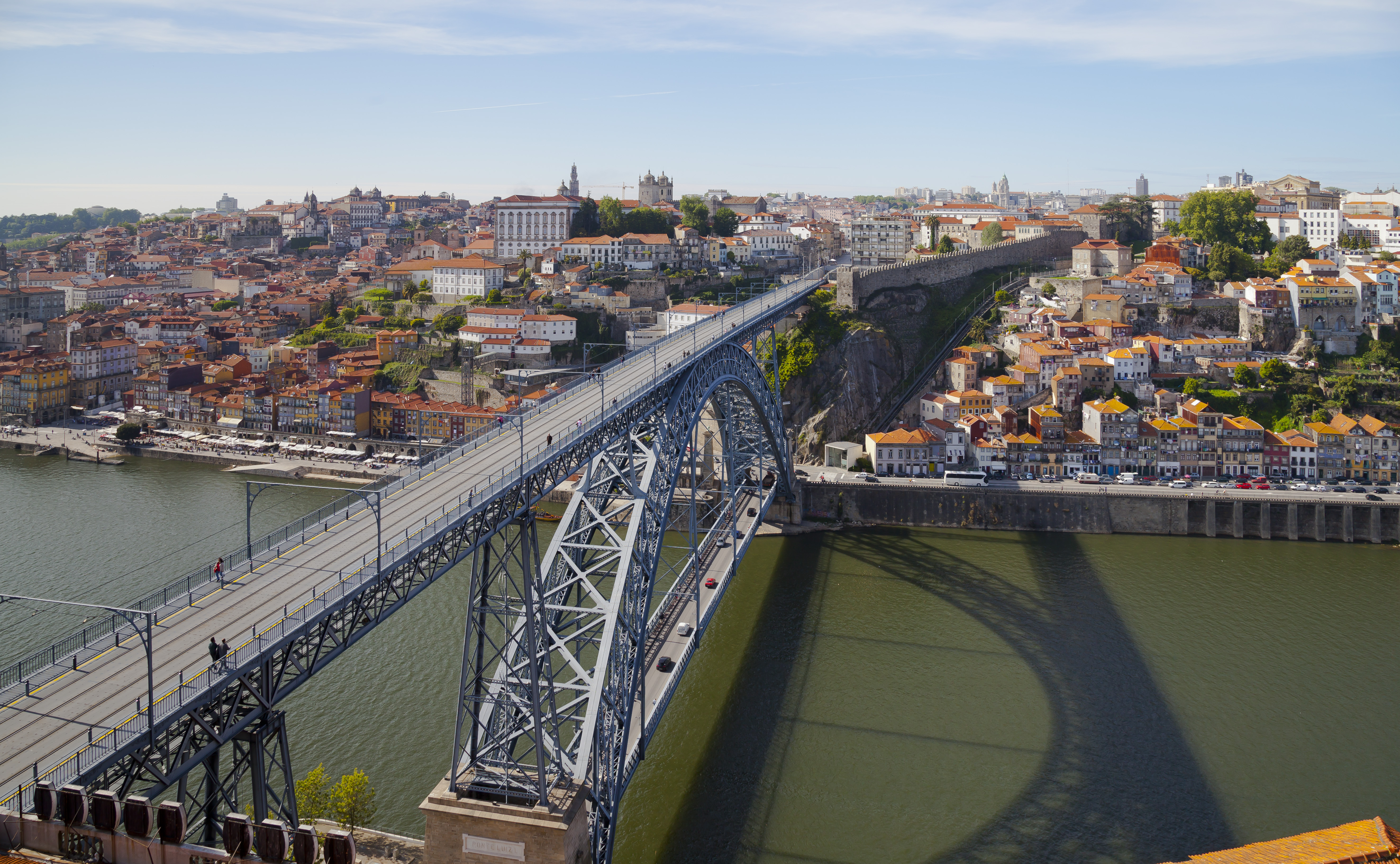
Dom Luis I Bridge
Gustave Eiffel wanted the job. In 1879, the man who would build the most famous tower in the world submitted a design for a new bridge over the Douro River in Porto -- a single high deck to clear the masts of ships below. The city rejected it. Porto needed something more practical: two decks, not one, to handle the growing population pressing against both riverbanks. The commission went instead to Theophile Seyrig, Eiffel's former partner, and what emerged was the Dom Luis I Bridge -- a double-deck iron arch that was, at its completion in 1886, the longest span of its type in the world at 172 meters.
Two Decks, Two Cities
The bridge connects Porto on the north bank to Vila Nova de Gaia on the south, and its two levels serve as two different worlds. The lower deck lands at the Cais da Ribeira, Porto's historic waterfront, where the Praca da Ribeira opens onto the river and the Guindais Funicular climbs the granite cliff above. On the Gaia side, it deposits visitors among the Port wine lodges -- the stone warehouses where the fortified wine that made the region famous ages in oak barrels. The upper deck, 60 meters above the water, connects to Porto's city center near Sao Bento railway station, with its famous azulejo-tiled hall, and on the Gaia side adjoins the Serra do Pilar Monastery and the Gaia Cable Car. Walking from one deck to the other means crossing not just a river but a change in altitude, perspective, and neighborhood.
Iron Against Granite
The bridge sits in a natural box valley where the granite banks of the Douro rise steeply on both sides, framed by the Cathedral of Porto to the north and the escarpment of Serra do Pilar to the south. The central arch springs from massive stone foundations on each bank, its ironwork thinning as it curves upward toward the center -- an engineering solution that distributes weight along the parabolic curve. Both decks are anchored to the riverbanks by masonry piers. At the base of the arches, marble plaques bear the inscription 'PONTE LUIZ I,' and upstream-facing stones carry royal coats of arms framed by garlands. The bridge's silhouette closely resembles the nearby Maria Pia Bridge, a railway span designed by Eiffel himself and completed nine years earlier, just one kilometer to the east.
From Horse-Drawn Trams to Metro Trains
For over a century, the upper deck carried motor vehicles, a stream of traffic suspended high above the Douro. That changed on June 27, 2003, when the upper deck closed to cars to be retrofitted for Porto's metro system. The Infante Dom Henrique Bridge, completed three months earlier upriver, absorbed the displaced vehicle traffic. Line D of the Porto Metro began running across the upper deck on September 18, 2005, and light rail trains now glide across the span that once carried horse-drawn trams. When the lower deck reopened in April 2023 after its own renovation, private cars were excluded entirely -- the deck now serves only public transport, taxis, cyclists, and pedestrians. The bridge has evolved from a 19th-century engineering marvel into a piece of 21st-century urban transit infrastructure, its iron bones supporting a purpose its designers never imagined.
The View That Defines Porto
The Dom Luis I Bridge is not just a crossing; it is the photograph. Nearly every image of Porto features its arc of iron framing the Ribeira waterfront, the stacked colorful buildings climbing the north bank, the Port wine lodges on the south. From the upper deck, pedestrians look straight down 60 meters to the river, where rabelo boats -- the flat-bottomed vessels once used to transport wine barrels from the Douro Valley -- still bob at the quayside. The bridge ties together the two banks that define Porto's identity: the medieval trading city on the north, the wine industry on the south. It is one of six bridges crossing the Douro within the city limits, but it is the one people remember. At night, when the ironwork is illuminated and the reflections stretch across the dark water, the bridge becomes less a piece of infrastructure than a stage set for the city behind it.
From the Air
Located at 41.14N, 8.61W, spanning the Douro River between Porto and Vila Nova de Gaia, Portugal. The double-deck iron arch is unmistakable from the air, sitting between the Maria Pia Bridge (1 km east) and the Arrabida Bridge (further west). Nearest airport is LPPR (Francisco Sa Carneiro, ~11 km northwest). The bridge is at the heart of Porto's UNESCO World Heritage riverside, with the dense historic center visible on the north bank and the wine lodges on the south. The Douro Valley extends eastward into the interior.